Until 1832, the Delhi Division was controlled by the Residency. Regulation V of that year, abolished the office of Resident and annexed the Delhi territory to the jurisdiction of the Sadr Board and Courts of Justice at Allahabad, which included the Commissioner of the Delhi territory and all officers acting under his control, ordinarily to "or form to the principles and spirit of the regulations" in their his control, ordinarily to administration.
After the Indian rebellion of 1857, the Delhi Division of the North-Western Provinces was transferred to the Punjab in 1858, and formed into the Delhi and Hissar divisions, which embraced the six districts of Delhi, Gurgaon, Panipat, Rohtak, Hissar and Sirsa.[1]
Haryana is an Indian state located in the northern part of the country. It was carved out of the former state of East Punjab on 1 November 1966 on a linguistic basis. It is ranked 21st in terms of area, with less than 1.4% of India's land area. The state capital is Chandigarh, which it shares with the neighboring state of Punjab, and the most populous city is Faridabad, which is a part of the National Capital Region. The city of Gurugram is among India's largest financial and technology hubs. Haryana has 6 administrative divisions, 22 districts, 72 sub-divisions, 93 revenue tehsils, 50 sub-tehsils, 140 community development blocks, 154 cities and towns, 7,356 villages, and 6,222 villages panchayats.
The United Provinces of Agra and Oudh was a province of India under the British Raj, which existed from 1902 to 1921; the official name was shortened by the Government of India Act 1935 to United Provinces (UP), by which the province had been commonly known, and by which name it was also a province of independent India until 1950.
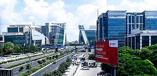
The National Capital Region (NCR) is a planning region centred upon the National Capital Territory (NCT) of Delhi in India. It encompasses Delhi and several districts surrounding it from the states of Haryana, Uttar Pradesh and Rajasthan. The NCR and the associated National Capital Region Planning Board (NCRPB) were created in 1985 to plan the development of the region and to evolve harmonized policies for the control of land-uses and development of infrastructure in the region. Prominent cities of NCR include Delhi, Faridabad, Ghaziabad, Gurugram, and Noida.
Punjab was a province of British India. Most of the Punjab region was annexed by the East India Company in 1849, and was one of the last areas of the Indian subcontinent to fall under British control. In 1858, the Punjab, along with the rest of British India, came under the direct rule of the British Crown. It had an area of 358,354.5 km2.
Panipat district is one of the 22 districts of Haryana in north India. The historical town of Panipat is the administrative headquarters of the district. The district occupies an area of 1,268 km2 (490 sq mi), making it the nineteenth largest in the state with Gurugram and Panchkula following it.
Rohtak is a city and the administrative headquarters of the Rohtak district in the Indian state of Haryana. It lies 70 kilometres (43 mi) north-west of New Delhi and 250 kilometres (160 mi) south of the state capital Chandigarh on NH 9(old NH 10). Rohtak forms a part of the National Capital Region (NCR) which helps the city in obtaining cheap loans for infrastructure development from the NCR Planning Board.
National Highway 10 was a National Highway, length 403 km (250 mi), in North India that originated at Delhi and ended at the town of Fazilka in Punjab near the Indo-Pak Border.
Haryana is a state in India. The state houses several sites from the Indus Valley Civilization, which was a cradle of civilization. In the Mahabharata, Haryana is mentioned as Bahudanayak Region.
Haryana, formed on 1 November 1966, is a state in North India. For the administrative purpose, Haryana is divided into 6 revenue divisions which are further divided into 22 districts. For Law and Order maintenance, it is divided into 5 Police Ranges and 3 Police Commissionerates.
Kotia is a village located in Kanina tehsil, district Mahendragarh, Haryana state of India. It is on the Kosli–Kanina road and is 17 kilometres from Kosli and 3 kilometres from Kanina.
The following outline is provided as an overview of and topical guide to Haryana.
Madhogarh Fort is a fort located on top of Madhogarh Hill in the Aravalli mountain range, near Madhogarh village, in the Mahendragarh district of Haryana state in India. It is located 12 kilometres (7.5 mi) from Mahendragarh, reachable via Satnali Chowk or via Mahendragarh- Satnali- Loharu road.
Tourism in Haryana relates to tourism in the state of Haryana, India. There are 21 tourism hubs created by Haryana Tourism Corporation (HTC), which are located in Ambala, Bhiwani Faridabad, Fatehabad, Gurgaon, Hisar, Jhajjar, Jind, Kaithal, Karnal, Kurukshetra, Panchkula, Sirsa, Sonipat, Panipat, Rewari, Rohtak, Yamunanagar, Palwal and Mahendergarh.
Bisahan is a village in the Beri tehsil of Jhajjar district of Haryana, India. The village lies roughly 5 kilometres (3.1 mi) from the town of Beri.
Western Yamuna Canal is canal in river Yamuna that was dug out and renovated in 1335 CE by Firoz Shah Tughlaq. In 1750 CE, excessive silting caused it to stop flowing. The British raj undertook a three-year renovation in 1817 by Captain GR Blane of the Bengal Engineer Group. In 1832-33 Tajewala Barrage dam at Yamuna was also built to regulate the flow of water, and later Pathrala barrage at Dadupur and Somb river dam downstream of canal were constructed in 1875-76. In 1889-95 the largest branch of the canal Sirsa branch was constructed. The modern Hathni Kund Barrage was built in 1999 to handle the problem of silting to replace the older Tajewala Barrage.
Rail network in the state of Haryana in India, is covered by 5 rail divisions under 3 rail zones, namely, North Western Railway zone, Northern Railway zone and North Central Railway zone.
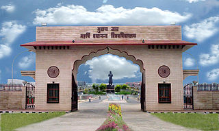
Haryana State Industrial and Infrastructure Development Corporation (HSIIDC), formerly Haryana State Industrial Development Corporation (HSIDC), headquartered at Panchkula, is a 100% state-owned agency of the government of Haryana in the Indian state of Haryana. For ease of doing business, Haryana is the first state in India to introduce a labour policy in 2005 and Land Pooling Policy in 2017, for which HSIIDC acts as the nodal agency. Haryana Financial Corporation provides financial assistance for setting up new industrial units and for the expansion and diversification of the existing industries. Various universities, educational and training institutes, including the nation's first skills university Haryana Vishwakarma Skill University, provide the human resources to capitalise on the infrastructure created by the HSIIDC.
The Trans–Haryana Expressway or the Ambala–Narnaul Expressway (NH-152D) is a 227-km long, 6-lane wide access-controlled expressway, connecting the cities of Ambala and Narnaul in the state of Haryana. The expressway connects Gangheri village in Kurukshetra district with Surana village on Narnaul Bypass (NH-148B) in Mahendragarh district. It passes via Kaul, Pundri, Assandh, Dhatrath, Kalanaur, Charkhi Dadri and Kanina. It will reduce the distance from Chandigarh to Delhi, Narnaul, and Jaipur, thus decongesting NH-44 and NH-48.
This page is based on this Wikipedia article Text is available under the CC BY-SA 4.0 license; additional terms may apply. Images, videos and audio are available under their respective licenses.