
The London and Birmingham Railway (L&BR) was a railway company in the United Kingdom, in operation from 1833 to 1846, when it became part of the London and North Western Railway (L&NWR).

The A5, the London-Holyhead trunk road, is a major road in England and Wales. It runs for about 243 miles (391 km) from London to the Irish Sea at the ferry port of Holyhead. In many parts the route follows that of the Roman Iter II route which later took the Anglo-Saxon name Watling Street.

Bletchley is a constituent town of Milton Keynes, Buckinghamshire, England. It is situated in the south-west of the city, and is split between the civil parishes of Bletchley and Fenny Stratford and West Bletchley. In 2011, the two parishes had a combined population of 37,114.

Rugby railway station serves the market town of Rugby in Warwickshire, England. The current station dates from 1885; two previous stations dating from 1838 and 1840 respectively, existed at locations to the west of the current one. It has been Rugby's only station, since the closure of the former Rugby Central station in 1969, on the now-abandoned Great Central Main Line route through the town. Between 1950 and 1970, the station was known as Rugby Midland before reverting to its original title. The station underwent an extensive remodelling between 2006 and 2008; new platforms were added and a new ticket office and entrance building were constructed. The original Victorian part of the station was retained in the upgrade.
Denbigh is a district in Milton Keynes, Buckinghamshire, England, to the north of Fenny Stratford and on the eastern side of the West Coast Main Line. It is in the civil parish of Bletchley and Fenny Stratford and is categorised by the Office for National Statistics as part of the Bletchley built-up area. The A5 forms its eastern and northern boundary; parts of Bletcham Way and Saxon St form its southern boundary. The overall district has five sub districts, divided by Watling St/Denbigh Rd, the 'uptick' of Bletcham Way and Grafton Street, and Saxon Street northbound. The district names are planning designations that have persisted without ever being changed to the style "North Denbigh" etc. as is the norm elsewhere in Britain.

Bletchleyrailway station serves the southern parts of Milton Keynes, England, and the north-eastern parts of Aylesbury Vale. It is 47 miles (76 km) northwest of Euston, about 32 miles (51 km) east of Oxford and 17 miles (27 km) west of Bedford, and is one of the seven railway stations serving the Milton Keynes urban area.

Wolverton railway station serves Wolverton, a constituent town of Milton Keynes, Buckinghamshire, England. The station is on the West Coast Main Line, about 52 miles (84 km) from Euston, between Milton Keynes Central and Northampton. The station is one of the seven stations serving the Milton Keynes urban area.

Coventry railway station is the main railway station serving the city of Coventry, West Midlands, England. The station is on the Birmingham loop of the West Coast Main Line (WCML); it is also located at the centre of a junction where the lines to Nuneaton and to Leamington converge. It is situated on the southern edge of the city-centre, just outside the Coventry ring road, about 250 yards to the south of junction 6.

Berkhamsted railway station is in the town of Berkhamsted, Hertfordshire, England. It is located just beside Berkhamsted Castle, overlooking the Grand Junction Canal. The station is 28 miles (45 km) north west of London Euston on the West Coast Main Line. London Northwestern Railway operates services to London, Northampton and many other destinations.

Tring railway station is 1.5 miles (2.4 km) outside the market town of Tring, close to the Grand Union Canal but actually nearer to the village of Aldbury in Hertfordshire, England. Situated on the West Coast Main Line, the station is now an important marshalling point for commuter trains from here for most stations to London Euston.
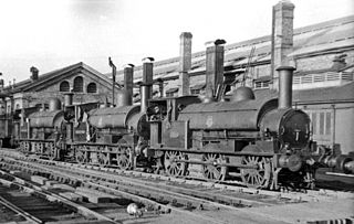
Wolverton railway works, known locally as Wolverton Works or just The Works, was established in Wolverton, Buckinghamshire, by the London and Birmingham Railway Company in 1838 at the midpoint of the 112-mile-long (180-kilometre) route from London to Birmingham. The line was developed by Robert Stephenson following the great success of the Liverpool and Manchester Railway line.

The Milton Keynes grid road system is a network of predominantly national speed limit, fully landscaped routes that form the top layer of the street hierarchy for both private and public transport in Milton Keynes, Buckinghamshire. The system is unique in the United Kingdom for its innovative use of street hierarchy principles: the grid roads run in between districts rather than through them. This arrangement permits higher speed limits due to the absence of buildings close to the roads – although more recently some have been limited in part to 40 mph (64 km/h). The grid road system also serves an important purpose of discouraging through-traffic from travelling through neighborhoods and thus reduces traffic noise and pollution in pedestrian areas. Motor traffic is segregated from pedestrian and leisure cycling traffic, which uses the alternative Milton Keynes redway system. Almost all grid junctions are roundabouts, and the absence of traffic lights enables free and efficient movement of traffic.

Transport in Buckinghamshire has been shaped by its position within the United Kingdom. Most routes between the UK's two largest cities, London and Birmingham, pass through this county. The county's growing industry first brought canals to the area, then railways and then motorways.

Denbigh Hall railway station was a temporary terminus station on the London and Birmingham Railway in the Denbigh area of what is now Milton Keynes in Buckinghamshire, England. It was situated about 1 mile (1.6 km) north of Bletchley railway station, near a point where the railway crossed Watling Street. It was open for less than six months, between April and September 1838.

The Wolverton Works canal bridge, or Bridge no. 171C, is a bridge over the Grand Union Canal in Wolverton, Milton Keynes in south-eastern England. It carries a spur from the West Coast Main Line into Wolverton Works. It was built in 1834–1835 for the London and Birmingham Railway under the supervision of Robert Stephenson and has been little modified since. It is a grade II* listed building.

Brandon Viaduct is a railway viaduct crossing the River Avon between the villages of Brandon and Wolston in Warwickshire. It carries the Birmingham Loop line and is roughly half way between Rugby and Coventry. The bridge was built in around 1835 for the London and Birmingham Railway and is now a grade II listed building.

Wolverton Viaduct is a railway bridge carrying the West Coast Main Line over the River Great Ouse to the north of Wolverton, part of the City of Milton Keynes, in south-eastern England. Built in 1837 for the London and Birmingham Railway under the supervision of Robert Stephenson, it is one of the largest and most notable structures on the route and is a grade II listed building.

The Blisworth Arch is a railway bridge in Blisworth, Northamptonshire, in eastern England. It was designed by Robert Stephenson for the London and Birmingham Railway and completed in 1837. It is a grade II listed building and a significant local landmark.

Bushey Arches Viaduct is a railway bridge on the West Coast Main Line immediately north of Bushey railway station, between Bushey and Watford, in Hertfordshire, Eastern England, just north-west of London.

Tring Cutting is an earthwork on the southern part of the West Coast Main Line on the Hertfordshire–Buckinghamshire boundary near Tring in southern England. It was built for the London and Birmingham Railway to the specification of Robert Stephenson and opened with the line in 1837. The cutting is 2.5 miles long and has an average depth of 40 feet but reaches 60 feet at some points, making it one of the largest engineering works on the London and Birmingham's line. Three bridges that cross the cutting were built at the same time as the line and are listed buildings.

