Derby Racecourse Roman settlement

Last updated

Derby Racecourse Roman settlement
Green glazed jug Derby.jpg
A Green Glazed Jug from the Racecourse settlement
Derbyshire UK location map.svg
Archaeological site icon (red).svg
Map showing the location of Derby Racecourse Roman settlement within Derbyshire.
LocationDerby, Derbyshire
RegionEast Midlands
Coordinates 52°56′05″N1°27′49″W / 52.934672°N 1.463546°W / 52.934672; -1.463546
TypeRoman fort
Part of Icknield Street
History
Founded120
Site notes
Website www.roman-britain.org/places/derventio_coritanorum.htm
Pastscape

The Derby Racecourse Roman settlement was the third settlement in Derby or Derventio which was a small town in the Roman province of Britannia. It lies 600m east of Derventio fort in Little Chester, on the outskirts of Derby, in the English county of Derbyshire. [1] The Roman road from Derventio to Sawley on the River Trent passes the settlement. It is a scheduled National Monument.

Contents

Description

Roman spout in shape of a Duck's head, found at Derby racecourse and now at Derby Museum and Art Gallery Roman duck head spout, Derby.jpg
Roman spout in shape of a Duck's head, found at Derby racecourse and now at Derby Museum and Art Gallery

The first Roman fort in the area was built on the opposite bank of the River Derwent at Strutt's Park. It was replaced about AD 80 by a fort at Little Chester, but this only lasted about forty years, then decommissioned. The fort was later re-occupied and re-used for a further twenty five years then unoccupied until the late 3rd century when a stone wall was built around the town. [2] There is evidence of extensive Roman activity in Little Chester. Derby Racecourse Roman settlement site was founded around AD 90. [3] It is considered by English Heritage to be an import example of a fort-vicus. This was a civilian settlement attached to a Roman military fort- in this case Derventio. It is a mark that the Cornovii tribesmen were accepting the Roman way of life and integrating themselves into the Roman economy- i.e. Romanisation. [4]

Pottery kilns have been discovered dating from AD90 to the mid second century when ironworking took place. The jug illustrated was fired at this settlement and is now in Derby Museum. There was also a large cemetery with five stone mausolea. [5]

History

Romanbritain.jpg

This part of Britannica[ clarification needed ] was occupied by a tribe known as the Cornovii. In AD 46–47 the Roman Army under the direction of governor Aulius Plautius had probably occupied the lands to the south of the River Trent, so in AD 50 this was the front line. There is a shortage of written documentation about these years so reliance is made on archaeological excavations. Late in 47 the new governor of Britain, Ostorius Scapula, began a campaign against the tribes of modern-day Wales, and the Cheshire Gap. During these times Strutt's Park Roman fort, was one of the new forts built along the new supply road from Wroxeter to Rossington.

The campaign to conquer the Silures continued under the governor Quintus Veranius and his successor Gaius Suetonius Paulinus but by now Strutt Park's rôle was to maintain the peace. Around AD 74, the lands north of the River Mersey became unstable, when Queen Cartimandua had to ask for Roman assistance to fight off a rebellion. Then in AD78, Gnaeus Julius Agricola, made famous through the highly laudatory biography of him written by his son-in-law, Tacitus, was made governor. He consolidated the forts, improved the road infrastructure and led some now well documented campaigns- firstly in AD78, he reconquered North Wales, then in AD79 he conquered the Brigantes and Parisi taking all of Northern England up to the present Scottish border. Strutt's Park fort was vacated in AD 80 when Derventio was built.

Roman.Britain.Mining.jpg

The Emperor Hadrian visited Britannia in AD120 and ordered his wall to be built. Though Britannia always had a large garrison, focus now changed to industrial production. Derby produced pottery and had access to the lead mining to the north in the Peak District, later it became a centre for metalworking. This continued for the next 200 years.

Excavations

The site was excavated between 1968 and 1983.

Related Research Articles

<span class="mw-page-title-main">Icknield Street</span> Roman road in England

Icknield Street or Ryknild Street is a Roman road in England, with a route roughly south-west to north-east. It runs from the Fosse Way at Bourton on the Water in Gloucestershire to Templeborough in South Yorkshire. It passes through Alcester, Studley, Redditch, Metchley Fort, Birmingham, Sutton Coldfield, Lichfield, Burton upon Trent and Derby.

<span class="mw-page-title-main">Cornovii (Midlands)</span> Celtic people of the Iron Age and Roman Britain

The Cornovīī were a Celtic people of the Iron Age and Roman Britain, who lived principally in the modern English counties of Cheshire, Shropshire, north Staffordshire, north Herefordshire and eastern parts of the Welsh counties of Flintshire, Powys and Wrexham. Their capital in pre-Roman times was probably a hillfort on the Wrekin. Ptolemy's 2nd-century Geography names two of their towns: Deva Victrix (Chester) and Viroconium Cornoviorum (Wroxeter), which became their capital under Roman rule.

<span class="mw-page-title-main">Viroconium Cornoviorum</span> Ancient Roman city in Shropshire, England

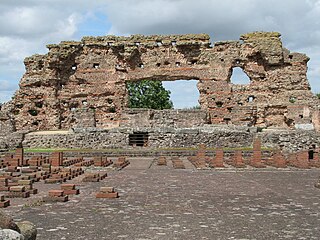
Viroconium or Uriconium, formally Viroconium Cornoviorum, was a Roman city, one corner of which is now occupied by Wroxeter, a small village in Shropshire, England, about 5 miles (8.0 km) east-south-east of Shrewsbury. At its peak, Viroconium is estimated to have been the 4th-largest Roman settlement in Britain, a civitas with a population of more than 15,000. The settlement probably lasted until the end of the 7th century or the beginning of the 8th. Extensive remains can still be seen.

<span class="mw-page-title-main">Wroxeter</span> Village in Shropshire, England

Wroxeter is a village and former civil parish, now in the parish of Wroxeter and Uppington, in the Shropshire district, in the ceremonial county of Shropshire, England. It is beside the River Severn, 5 miles (8.0 km) south-east of Shrewsbury. In 1961 the parish had a population of 657.

<span class="mw-page-title-main">History of Derbyshire</span> History of the county of Derbyshire in England

The history of Derbyshire can be traced back to human settlement since the last Ice Age, over 10,000 years ago. The county of Derbyshire in England dates back to the 11th century.

<span class="mw-page-title-main">Banna (Birdoswald)</span> Roman archelogical site in Cumbria, England

<span class="mw-page-title-main">Little Chester</span> Human settlement in England

Little Chester, also known as Chester Green after the area of open parkland at its centre, is a suburb of the city of Derby, in Derbyshire, England. It is located approximately 0.6 miles (0.97 km) north of the city centre, on the east bank of the River Derwent. It forms part of the Darley ward along with Darley Abbey and the West End. Little Chester is the oldest inhabited part of Derby, having been the location of a fortified Roman settlement called Derventio.

<span class="mw-page-title-main">Aquae Arnemetiae</span> Town in Roman Britain on the site of Buxton, England

<span class="mw-page-title-main">Derventio Coritanorum</span> Was a small town in Roman Britannia

Derventio was a small town in the Roman province of Britannia. Today the area is known as Little Chester, on the outskirts of Derby, located in the English county of Derbyshire.

<span class="mw-page-title-main">Castleshaw Roman Fort</span> Roman camp in Greater Manchester, England

Castleshaw Roman fort was a castellum in the Roman province of Britannia. Although there is no evidence to substantiate the claim, it has been suggested that Castleshaw Roman fort is the site of Rigodunum, a Brigantian settlement. The remains of the fort are located on Castle Hill on the eastern side of Castleshaw Valley at the foot of Standedge but overlooking the valley. The hill is on the edge of Castleshaw in Greater Manchester. The fort was constructed in c. AD 79, but fell out of use at some time during the 90s. It was replaced by a smaller fortlet, built in c. 105, around which a civilian settlement grew. It may have served as a logistical and administrative centre, although it was abandoned in the 120s.

<span class="mw-page-title-main">Alauna (Maryport)</span> Roman fort and settlement on the site of present-day Maryport in Cumbria, England

Alauna was a castrum or fort in the Roman province of Britannia. It occupied a coastal site just north of the town of Maryport in the English county of Cumbria.

<span class="mw-page-title-main">Inveresk Roman Fort</span> Archaeological site in East Lothian, Scotland

Inveresk Roman Fort is an archaeological site within the grounds of St Michael's Church, Inveresk, a village in East Lothian, Scotland.

<span class="mw-page-title-main">Strutt's Park Roman Fort</span>

Strutt's Park Roman Fort was a Roman fort in Strutt's Park, a suburb of Derby in Derbyshire, England. It was built around the year 50 and replaced, probably between the years 75 and 80, by a new fort at Little Chester on the opposite bank of the River Derwent.

<span class="mw-page-title-main">The Street (Derbyshire)</span> Roman road in England, linking Derby and Manchester

The Street is the medieval name of the Roman road that ran across the high limestone plateau of central Derbyshire from the spa town of Buxton southeast towards modern Derby. The line of the road can be traced from surviving features, confirmed by archaeology, from Buxton as far as Longcliffe just north of Brassington. It is believed that from Brassington the road ran eastwards to Wirksworth and there joined another road which crossed the Derwent at Milford and ran on the east bank of the Derwent and can be traced to the northern suburbs of Derby to Little Chester, the site of the Roman settlement of Derventio. The 1723 map of Brassington Moor shows The Street road from Buxton through Pikehall up to the Upper Harborough Field Gate, leading onto Manystones Lane & Brassington Lane towards Wirksworth. In records from 1613 the road from Brassington to Wirksworth is called 'Highe Streete'.

The Long Lane is the medieval and modern name of the Roman road that ran almost due westwards from Derventio, the Roman fort and vicus in the suburbs of modern Derby, through Derbyshire to Rocester and Draycott in the Moors. From that point onwards the same road – no longer called "The Long Lane" – continued through Staffordshire to Chesterton near Newcastle-under-Lyme. Its destination was Middlewich, from which the important city of Chester was in easy reach.

Rykeneld Street or Ryknield Street was a Roman road which ran through the northern Midlands of England from Deva (Chester) to Derventio (Derby) via what is now Stoke-on-Trent. It is not to be confused with the Icknield Street. It has in the past also been called by Victorian antiquarians the "Via Devina". The territory traversed would have been that of the Cornovii.

Derventio was a Roman settlement at Papcastle on the river Derwent near Cockermouth, Cumbria, England. It was the site of a Roman fort, which was originally built in timber and rebuilt in stone. There was also a civilian settlement (vicus). It is sometimes called Derventio Carvetiorum by modern writers to distinguish it from other places named Derventio, but there is no evidence of that extended name being used in the Roman period.

<span class="mw-page-title-main">Derventio Brigantum</span> Ancient Roman fort in present-day North Yorkshire, England

Derventio, sometimes described as Derventio Brigantium in order to distinguish it from other places called Derventio, was a Roman fort and settlement located beneath the modern town of Malton in North Yorkshire, England. The fort is positioned 18 miles north-east of Eboracum on the River Derwent.

<span class="mw-page-title-main">Navio Roman Fort</span> Roman fort near Hope in Derbyshire, England

Navio Roman fort overlooks a tight bend of the River Noe at Brough-on-Noe near Hope, Derbyshire, in England. Navio fort and vicus is a Scheduled Monument.

<span class="mw-page-title-main">Lutudarum</span> Town in Roman Britain in mid-Derbsyhire

Lutudarum was a town in the Roman province of Britannia, in the area that is now mid-Derbyshire. The settlement is believed to have been at either Wirksworth or nearby Carsington, although Matlock and Cromford are other candidates. The town was recorded as Lutudaron between Derventio and Veratino (Rocester) in the Ravenna Cosmography's list of all known places in the world in about 700 AD.

References

  1. Burnham, Barry C; Wacher, John (1990). The Small Towns of Roman Britain. London: B T Batsford. ISBN   978-0-520-07303-6.
  2. Vinnels, Maria (15 June 2006). "Manor Kingsway SPD Derby" (PDF). White Young Green Environment Ltd for English Heritage. Archived from the original (PDF) on 25 April 2012. Retrieved 25 July 2011.
  3. "Roman industrial site on Derby Racecourse". Pastscapes. English Heritage. Archived from the original on 3 October 2012. Retrieved 25 July 2011.
  4. "Derby Racecourse Roman vicus & cemetery" (PDF). Derby City Council. Archived from the original (PDF) on 27 September 2011. Retrieved 23 May 2011.
  5. Clay, Patrick; Sam George (2008). "An Archaeological Desk-Based Assessment for Proposed Development at the former Union Iron Foundry, City Road, Derby (SK 353 372)" (PDF). University of Leicester Archaeological Services. Archived from the original (PDF) on 15 August 2011. Retrieved 25 July 2011.

Bibliography