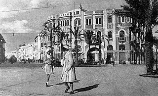
Tripoli is the capital and largest city of Libya, with a population of about 1.317 million people in 2021. It is located in the northwest of Libya on the edge of the desert, on a point of rocky land projecting into the Mediterranean Sea and forming a bay. It includes the port of Tripoli and the country's largest commercial and manufacturing center. It is also the site of the University of Tripoli.
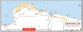
Operation Sonnenblume was the name given to the dispatch of German and Italian troops to North Africa in February 1941, during the Second World War. The Italian 10th Army had been destroyed by the British, Commonwealth, Empire and Allied Western Desert Force attacks during Operation Compass (9 December 1940 – 9 February 1941). The first units of the new Deutsches Afrikakorps (DAK), commanded by Generalleutnant Erwin Rommel, departed Naples for Africa and arrived on 11 February 1941. On 14 February, advanced units of the 5th Light Afrika Division, Aufklärungsbataillon 3 and Panzerjägerabteilung 39 arrived at the Libyan port of Tripoli and were sent immediately to the front line east of Sirte.

Misrata is a city in northwestern Libya located in the Misrata District, situated 187 km (116 mi) to the east of Tripoli on the Mediterranean coast near Cape Misrata. With a population of about 881,000, it is the third-largest city in Libya, after Tripoli and Benghazi. It is the capital city of the Misrata District and has been called the economic and trade capital of Libya. The harbor is at Qasr Ahmad.
The Italian invasion of Libya occurred in 1911, when Italian troops invaded the Turkish province of Libya and started the Italo-Turkish War. As result, Italian Tripolitania and Italian Cyrenaica were established, later unified in the colony of Italian Libya.

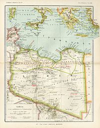
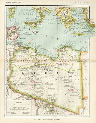
The Provinces of Libya were prescribed in 1934, during the last period of colonial Italian Libya, and continued through post-independence Libya until 1963 when the Governorates system was instituted.

The Italian colonizationof Libya began in 1911 and it lasted until 1943. The country, which was previously an Ottoman possession, was occupied by Italy in 1911 after the Italo-Turkish War, which resulted in the establishment of two colonies: Italian Tripolitania and Italian Cyrenaica. In 1934, the two colonies were merged into one colony which was named the colony of Italian Libya. In 1937, this colony was divided into four provinces, and in 1939, the coastal provinces became a part of metropolitan Italy as the Fourth Shore. The colonization lasted until Libya's occupation by Allied forces in 1943, but it was not until the 1947 Paris Peace Treaty that Italy officially renounced all of its claims to Libya's territory.

Derna is a port city in eastern Libya. With a population of around 90,000, Derna was once the seat of one of the wealthiest provinces among the Barbary States. The city is now the administrative capital of Derna District, which covers a much smaller area than the old province. Among Libyan cities, Derna has a unique location and physical environment, as it lies between the Jebel Akhdar, the Mediterranean Sea, and the desert and is the fourth most important port in Cyrenaica's northern coast after Benghazi, Bayda and Tobruk. The city is also home to people of many different backgrounds.
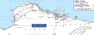
The Battle of Beda Fomm took place following the rapid British advance during Operation Compass. The Italian 10th Army was forced to evacuate Cyrenaica, the eastern province of Libya. In late January, the British learned that the Italians were retreating along the Litoranea Balbo from Benghazi. The 7th Armoured Division was dispatched to intercept the remnants of the 10th Army by moving through the desert, south of the Jebel Akhdar via Msus and Antelat as the 6th Australian Division pursued the Italians along the coast road, north of the jebel. The terrain was hard going for the British tanks and Combeforce, a flying column of wheeled vehicles, was sent ahead across the chord of the jebel.

Libya was a colony of Fascist Italy located in North Africa, in what is now modern Libya, between 1934 and 1943. It was formed from the unification of the colonies of Cyrenaica and Tripolitania, which had been Italian possessions since 1911.
Italian Tripolitania was an Italian colony, located in present-day western Libya, that existed from 1911 to 1934. It was part of the territory conquered from the Ottoman Empire after the Italo-Turkish War in 1911. Italian Tripolitania included the western northern half of Libya, with Tripoli as its main city. In 1934, it was unified with Italian Cyrenaica in the colony of Italian Libya. In 1939, Tripolitania was considered a part of the Kingdom of Italy's 4th Shore.
Italian Cyrenaica was an Italian colony, located in present-day eastern Libya, that existed from 1911 to 1934. It was part of the territory conquered from the Ottoman Empire during the Italo-Turkish War of 1911, alongside Italian Tripolitania.

Italian Libyans are Libyan-born citizens who are fully or partially of Italian descent, whose ancestors were Italians who emigrated to Libya during the Italian diaspora, or Italian-born people in Libya. Most of the Italians moved to Libya during the Italian colonial period.

The Italian invasion of Egypt was an offensive in the Second World War from Italian Libya, against British, Commonwealth and Free French in the neutral Kingdom of Egypt. The invasion by the Italian 10th Army ended border skirmishing on the frontier and began the Western Desert Campaign (1940–1943) proper. The Italian strategy was to advance from Libya along the Egyptian coast to seize the Suez Canal. After numerous delays, the scope of the offensive was reduced to an advance as far as Sidi Barrani and the defeat of any British forces in the area.

The Libyan Coastal Highway, formerly the Litoranea Balbo, is a highway that is the only major road that runs along the entire east-west length of the Libyan Mediterranean coastline. It is a section in the Cairo–Dakar Highway #1 in the Trans-African Highway system of the African Union, Arab Maghreb Union and others.
Tripoli Province was one of the provinces of Libya under Italian rule. It was established in 1937, with the official name: Commissariato Generale Provinciale di Tripoli. It lasted until 1947.
Benghazi Province, or Provincia di Bengasi in Italian, was one of the provinces of Libya under Italian rule. It was established in 1937.

Misrata Governorate was one of the governorates (muhafazah) of Libya from 1963 to 1983. Its capital was the town of Misrata. Initially in the 1930s was called "Provincia di Misurata" of Italian Libya. It was created out of the eastern part of Tripolitania province.
The Southern Military Territory was a jurisdictional territory within the Italian colonies of Cyrenaica and Tripolitania (1911-1934) and later Italian Libya (1934–1947), administered by the Italian military in the Libyan Sahara.
Italian Benghazi was the name used during the Italian colonization of Libya for the port-city of Benghazi in Italian Cyrenaica.

The Fourth Shore or Italian North Africa was the name created by Benito Mussolini to refer to the Mediterranean shore of coastal colonial Italian Libya and, during World War II, Italian Tunisia in the fascist-era Kingdom of Italy, during the late Italian colonial period of Libya and the Maghreb.