
County Tyrone is one of the six counties of Northern Ireland, one of the nine counties of Ulster and one of the thirty-two traditional counties of Ireland. It is no longer used as an administrative division for local government but retains a strong identity in popular culture.

Coalisland is a small town in County Tyrone, Northern Ireland, with a population of 5,682 in the 2011 Census. Four miles from Lough Neagh, it was formerly a centre for coal mining.
Benburb ) is a village and townland in County Tyrone, Northern Ireland. It lies 7.5 miles from Armagh and 8 miles from Dungannon. The River Blackwater runs alongside the village as does the Ulster Canal.

Creggan is a townland in County Tyrone, Northern Ireland. It is situated in the historic barony of Omagh East and the civil parish of Termonmaguirk and covers an area of 4022 acres.

Drumquin is a village and townland in County Tyrone, Northern Ireland. It lies between Omagh and Castlederg, on the banks of the Drumquin River (Fairywater). It is situated in the civil parishes of both Longfield West and Longfield East. The main part of the village is located in Longfield East, in the townland of Drumnaforbe, whilst Longfield West is where its namesake townland Drumquin is located. Drumquin is in the historic barony of Omagh West.

Coagh is a small village in County Tyrone, Northern Ireland, five miles (8 km) east of Cookstown. Part of the village also extends into County Londonderry. It had a population of 545 people in the 2001 Census. It owes its existence to George Butle Conyngham of Springhill, and was founded in 1728 when King George II of Great Britain granted Conyngham a market charter allowing the village to host four fairs yearly. It is situated within Mid-Ulster District.

Ballymagorry or Ballymagory is a small village and townland in County Tyrone, Northern Ireland. It is west of Artigarvan and 5 kilometres (3.1 mi) north of Strabane. In the 2001 Census it had a population of 565. It lies within the Strabane District Council area and lies on the River Glenmornan.

Altamuskin or Altamooskan is a small village and townland in County Tyrone, Northern Ireland. It is situated in the historic barony of Clogher and the civil parish of Errigal Keerogue and covers an area of 1165 acres. In the 2014 Census Altamuskin had a population of 127 people. It lies within the Fermanagh and Omagh District Council area and is home to St Bridget's Altamuskin. The population of the townland declined during the 19th century:

Clady is a small village and townland in County Tyrone, Northern Ireland. It lies about 4 miles from Strabane on the River Finn and borders the Republic of Ireland. In the 2011 Census it had a population of 538 people. It is within Urney civil parish and the former barony of Strabane Lower. In local government it is part of the Derry City and Strabane District Council. The townland covers an area of 173 acres.
Altmore ) is a hamlet and townland in County Tyrone, Northern Ireland. It is five miles from Carrickmore and four miles from Pomeroy. The townland is actually called Altmore and is situated in the historic barony of Dungannon Middle and the civil parish of Pomeroy and covers an area of 1117 acres.

Ardboe is a large parish civil parish in east County Tyrone, Northern Ireland. It borders the western shore of Lough Neagh and lies within the Mid Ulster District Council area. It is also the name of the local civil parish, which incorporates both Mullinahoe and Moortown.

Brackaville or Bracaville is a village and townland near Coalisland in County Tyrone, Northern Ireland. It is situated in the historic barony of Dungannon Middle and the civil parish of Donaghenry and covers an area of 235 acres on the western side of Lough Neagh.
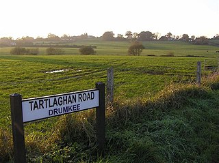
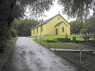
Drumkee is a townland in the southeast of County Tyrone, Northern Ireland. It is directly south of the area presently known as Coalisland and east, and slightly north, of Dungannon. It is situated in the historic barony of Dungannon Middle and the civil parish of Killyman and covers an area of 285 acres. The barony's tax records dated 1666 list two families living in Drumkee.

Carnteel ) is a hamlet, townland and civil parish, about 2 miles northeast of Aughnacloy in County Tyrone, Northern Ireland. It is situated in the historic barony of Dungannon Lower.

Brockagh is a village in County Tyrone, Northern Ireland. It is on the western shore of Lough Neagh, about 7 kilometres (4.3 mi) east of Coalisland and north of Washing Bay. It lies within the Mid Ulster District Council area.

Derrytresk is a townland outside Coalisland, County Tyrone, Northern Ireland and is close to the shores of Lough Neagh. It is situated in the historic barony of Dungannon Middle and the civil parish of Clonoe and covers an area of 1020 acres. Derrytresk consists of sub-townlands: Derryvarne, Derrykiltena and Derrynahaskila.
Altishane or Altishahane is a small settlement and townland in County Tyrone, Northern Ireland. It lies near Strabane, between Plumbridge and Donemana. It is situated in the historic barony of Strabane Lower and the civil parish of Donaghedy and covers an area of 744 acres. There is one primary school, Altishane Primary School.
Bullock Park is a townland in County Tyrone, Northern Ireland. It is situated in the historic barony of Omagh West and the civil parish of Longfield West and covers an area of 398 acres.
Crannogue is a townland in County Tyrone, Northern Ireland. It is situated in the historic barony of Dungannon Middle and the civil parish of Pomeroy and covers an area of 759 acres.
Carrickone is a townland in County Tyrone, Northern Ireland. It is situated in the historic barony of Strabane Lower and the civil parish of Urney and covers an area of 73 acres.


