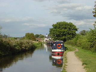
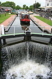
The Trent and Mersey Canal is a 93+1⁄2-mile (150 km) canal in Derbyshire, Staffordshire and Cheshire in north-central England. It is a "narrow canal" for the vast majority of its length, but at the extremities to the east of Burton upon Trent and north of Middlewich, it is a wide canal.

The Derwent is a river in Derbyshire, England. It is 50 miles (80 km) long and is a tributary of the River Trent, which it joins south of Derby. Throughout its course, the river mostly flows through the Peak District and its foothills.

The River Trent is the third-longest river in the United Kingdom. Its source is in Staffordshire on the southern edge of Biddulph Moor. It flows through and drains most of the metropolitan central and northern Midlands south and east of its source north of Stoke-on-Trent. The river is known for dramatic flooding after storms and spring snowmelt, which in past times often caused the river to change course.

The Cromford Canal ran 14.5 miles from Cromford to the Erewash Canal in Derbyshire, England with a branch to Pinxton. Built by William Jessop with the assistance of Benjamin Outram, its alignment included four tunnels and 14 locks.
The Derby Canal ran 14 miles (23 km) from the Trent and Mersey Canal at Swarkestone to Derby and Little Eaton, and to the Erewash Canal at Sandiacre, in Derbyshire, England. The canal was authorised by an Act of Parliament in 1793 and was fully completed in 1796. It featured a level crossing of the River Derwent in the centre of Derby. An early tramroad, known as the Little Eaton Gangway, linked Little Eaton to coal mines at Denby. The canal's main cargo was coal, and it was relatively successful until the arrival of the railways in 1840. It gradually declined, with the gangway closing in 1908 and the Little Eaton Branch in 1935. Early attempts at restoration were thwarted by the closure of the whole canal in 1964. Since 1994, there has been an active campaign for restoration spearheaded by the Derby and Sandiacre Canal Trust and Society. Loss of the Derwent crossing due to development has resulted in an innovative engineering solution called the Derby Arm being proposed, as a way of transferring boats across the river.

The Erewash Canal is a broad canal in Derbyshire, England. It runs just under 12 miles (19 km) and has 14 locks. The first lock at Langley Bridge is part of the Cromford Canal.

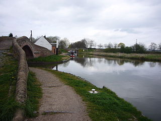
Shardlow is a village in Derbyshire, England about 6 miles (9.7 km) southeast of Derby and 11 miles (18 km) southwest of Nottingham. Part of the civil parish of Shardlow and Great Wilne, and the district of South Derbyshire, it is also very close to the border with Leicestershire, defined by route of the River Trent which passes close to the south. Just across the Trent is the Castle Donington parish of North West Leicestershire.
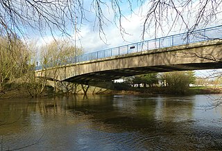
Trent Lock is located south of Long Eaton, on the borders of Derbyshire, Leicestershire and Nottinghamshire in the United Kingdom. The area is a major canal navigation junction, where the River Soar and Erewash Canal can reach the Trent and Mersey Canal by way of the River Trent and adjacent Cranfleet Cut.

Great Wilne is a small village in Derbyshire, England on the border with Leicestershire. It is 7 miles (11 km) south east of Derby. It is a village split from its church of St Chad's by the river. The church is at the very small hamlet of Church Wilne which can only be approached by a short walk via the bridge over the River Derwent, or by a fair car journey which necessitates travelling out of the county. The population at the 2011 Census is included in the civil parish of Shardlow and Great Wilne.

Trent railway station was situated near Long Eaton in Derbyshire at the junction of the Midland Railway line from London to Derby and Nottingham. It was unusual in that it did not serve any community, being simply an interchange. Forty years following closure, East Midlands Parkway railway station was opened for functionally similar purposes.
Twyford and Stenson is a civil parish in the South Derbyshire district of Derbyshire, England. Located south of Derby on the Trent and Mersey Canal, it consists of two villages, Stenson and its smaller neighbour Twyford.

The Piscassic River is a 15.3-mile-long (24.6 km) river located in southeastern New Hampshire in the United States. It is a tributary of the Lamprey River, part of the Great Bay and Piscataqua River watershed leading to the Atlantic Ocean.

A large number of canals were built in Cheshire, England, during the early phases of the Industrial Revolution to transport goods and raw materials. This resulted in a significant canal network which is now enjoyed by holiday-makers, anglers, walkers, and others.
Haywood Junction, or Great Haywood Junction, is the name of the canal junction where the Staffordshire and Worcestershire Canal terminates and meets the Trent and Mersey Canal near to the village of Great Haywood, Staffordshire, England.

Sawley is a village and civil parish within the Borough of Erewash, in southeast Derbyshire, England. With a slightly higher than average number of people over 65, the population of just the civil parish was measured at 6,629 as at the 2011 Census.
The Derwent Valley Heritage Way (DVHW) is a 55 miles (89 km) waymarked footpath along the Derwent Valley through the Peak District. The walk starts from Ladybower Reservoir in the Peak District National Park via Chatsworth, the scenery around the Derbyshire Dales, and through the Derwent Valley Mills World Heritage Site. It follows the Riverside Path through Derby and continues onwards to the historic inland port of Shardlow. Journey's end is at Derwent Mouth where the River Derwent flows into the River Trent.
Cavendish Bridge is a bridge over the River Trent, connecting the counties of Leicestershire and Derbyshire; it is also the name of a hamlet on the Leicestershire side of the river within the Castle Donington parish. This bridge once carried the main London-Manchester turnpike, though the modern A6/A50 dual carriageway has now been built to the south bypassing the crossing.

King's Mill is the traditional crossing point of the River Trent between Castle Donington in Leicestershire and Weston-on-Trent in Derbyshire. The Mill was the farthest point that traffic from the River Humber could progress. A lock was installed here to make the river navigable but the business eventually collapsed due to competition with the Trent and Mersey Canal. The mill was used for grinding flints for the pottery industry, locally mined plaster, and dyestuffs when it was owned by Samuel Lloyd of the Birmingham banking company.

