
The North Country National Scenic Trail, generally known as the North Country Trail or simply the NCT, is a footpath stretching over 4,800 miles (7,700 km) from Middlebury in central Vermont to Lake Sakakawea State Park in central North Dakota in the United States; connecting both the Long Trail and the Appalachian Trail with the Lewis and Clark Trail. Passing through the eight states of Vermont, New York, Pennsylvania, Ohio, Michigan, Wisconsin, Minnesota and North Dakota, it is the longest of the eleven National Scenic Trails authorized by Congress. As of early 2019, 3,129 miles (5,036 km) of the trail is in place.
The Felsenthal National Wildlife Refuge (NWR) is a 76,000 acre national wildlife refuge located in south-central Arkansas in Ashley, Bradley, and Union counties. Felsenthal NWR is one of three refuges forming an administrative complex, which also includes Pond Creek NWR to the northwest and Overflow NWR to the east.

The Souris River or Mouse River is a river in central North America. Approximately 435 miles (700 km) in length, it drains about 23,600 square miles (61,100 km2) in Canada and the United States.
The Charles M. Russell National Wildlife Refuge is a National Wildlife Refuge in the U.S. state of Montana on the Missouri River. The refuge surrounds Fort Peck Reservoir and is 915,814 acres (3,706.17 km2) in size. It is the second-largest National Wildlife Refuge in the lower 48 states of the United States, and the largest in Montana. Created in 1936, it was originally called the Fort Peck Game Range. It was renamed in 1963 after Montana artist Charles M. Russell, a famous painter of the American West. In 1976, the "range" was made a "refuge".

Malheur National Wildlife Refuge is a National Wildlife Refuge located roughly 30 miles (48 km) south of the city of Burns in Oregon's Harney Basin. Administered by the United States Fish and Wildlife Service, the refuge area is roughly T-shaped with the southernmost base at Frenchglen, the northeast section at Malheur Lake and the northwest section at Harney Lake.

John Clark Salyer II was an American environmentalist and government administrator.

The National Wildlife Refuge System in the United States has a long and distinguished history.
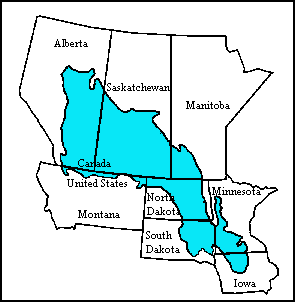
The Prairie Pothole Region is an expansive area of the northern Great Plains that contains thousands of shallow wetlands known as potholes. These potholes are the result of glacier activity in the Wisconsin glaciation, which ended about 10,000 years ago. The decaying ice sheet left behind depressions formed by the uneven deposition of till in ground moraines. These depressions are called potholes, glacial potholes, kettles, or kettle lakes. They fill with water in the spring, creating wetlands, which range in duration from temporary to semi-permanent. The region covers an area of about 800,000 sq. km and expands across three Canadian provinces and five U.S. states. The hydrology of the wetlands is variable, which results in long term productivity and biodiversity. The PPR is a prime spot during breeding and nesting season for millions of migrating waterfowl.

Audubon National Wildlife Refuge is a 14,739-acre (5,965 ha) National Wildlife Refuge in the U.S. state of North Dakota. The refuge is managed by the U.S. Fish and Wildlife Service and is the centerpiece of the Audubon National Wildlife Refuge Complex, which includes numerous other refuges in the region. Originally designated as the Snake Creek National Wildlife Refuge in 1955, the refuge was renamed in 1967 in honor of the artist and naturalist John James Audubon. Most of the refuge area is a lake known as Audubon Lake which is managed by the U.S. Army Corps of Engineers.
The Des Lacs National Wildlife Refuge is located in the U.S. state of North Dakota and extends from the Canada–United States border to near the town of Kenmare, North Dakota along Des Lacs Lake. The refuge was established in 1935 and includes 19,500 acres (78.9 km2). The refuge is considered to be one of the most important bird sanctuaries in the U.S., with tens of thousands of birds using the refuge for migration and breeding. The refuge is also home to elk, moose, bison and pronghorn.
Shell Lake National Wildlife Refuge is a 1,835-acre (743 ha) National Wildlife Refuge in the U.S. state of North Dakota. Though wildlife viewing is allowed, hunting and fishing are prohibited. The refuge is managed by the Lostwood Wetland Management District.

Lake Zahl National Wildlife Refuge is a 3,823-acre (1,547 ha) National Wildlife Refuge in Williams County in the U.S. state of North Dakota. The refuge consists of Lake Zahl which provides habitat for many species of waterfowl and other species. It is managed by the Crosby Wetland Management District.

Wapato Lake was a historic lake located in what became parts of Washington County and Yamhill County in the U.S. state of Oregon. The area is sometimes known as Wapato Lake Bed and Wapato Flat. The lake bed is located about a half mile east of Gaston at 55 metres (180 ft) elevation. The lake bed soils contain a layer of organic peat that once supported a wetland community dominated by the wapato plant, Sagittaria latifolia, particularly in the upper marsh areas.

Straddling the headwaters of the Minnesota River in west-central Minnesota, Big Stone National Wildlife Refuge is within the heart of the tallgrass prairie's historic range. Today, less than one-percent of tallgrass prairie remains.
Upper Souris National Wildlife Refuge, located 30 miles (48 km) northwest of Minot, North Dakota, was established in 1935 as a refuge and breeding ground for migratory birds and other wildlife. The refuge straddles 35 miles (56 km) of the picturesque Souris River valley in northern North Dakota. The Souris River basin figures prominently in the cultural and natural history of the North American mid-continent plains and prairies.

J. Clark Salyer National Wildlife Refuge is located along the Souris River in Bottineau and McHenry Counties in north-central North Dakota. The refuge of 58,693 acres (237.5 km2) extends from the Manitoba border southward for approximately 45 miles (72 km) in an area which was once Glacial Lake Souris. The area is old lake bottom and has extremely flat topography and a high density of temporary wetlands.

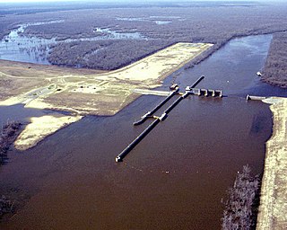
Lake Darling Dam is an earthen embankment dam on the Souris River in the west north central United States, located twenty miles (30 km) northwest of Minot in Ward County, North Dakota. The dam began impounding water in April 1936 and was completed July of that year; it was created for the purposes of water storage and conservation.
Brandon House was a Hudson's Bay Company post or posts from 1793 to 1824. It was located at several places on the Assiniboine River between Brandon, Manitoba and the mouth of the Souris River about 21 miles southeast of Brandon. Because of its location near the Souris River it was a center for trade with the Mandans in North Dakota. It was moved four times and there were related forts nearby, so its history is necessarily complex. For background see Assiniboine River fur trade.

The Lower Souris National Wildlife Refuge Airplane Hangar is an airplane hangar at the J. Clark Salyer National Wildlife Refuge near Upham, North Dakota. It is a prefabricated, T-shaped, rounded arch metal structure that was built in 1947 by Butler Manufacturing Company. It served as the home base for an airplane that was used to manage lands set aside for wildlife conservation in North Dakota and surrounding areas. The hangar was listed on the National Register of Historic Places in 2011.
