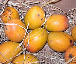
Devgad taluka

Last updated

Alphonso mango Devgad Alphonso Mango Original Pic by Devgad Taluka Mango Growers Co-op Society.jpg
Alphonso mango
Bastions of Vijaydurg fort Bastions of vijaydurg.jpg
Bastions of Vijaydurg fort
Alphonso mangoes (Hapoos), grown mainly in Maharashtra's Sindhudurg, Devgad, and Ratnagiri districts, are popular in the United States. Alphonso mango.jpg
Alphonso mangoes (Hapoos), grown mainly in Maharashtra's Sindhudurg, Devgad, and Ratnagiri districts, are popular in the United States.

Devgad is a taluka in Sindhudurg district of Maharashtra, India consisting of 98 villages. [2] It is located on the Arabian Sea in the coastal Konkan region of Maharashtra, south of Mumbai. Devgad is known globally for its exports of locally grown Alphonso mangoes. [3]

Contents

Devgad is a natural harbour which only small vessels can enter the harbour. [4]

History

It is noted for its harbour, its beach, and a lighthouse built in 1915 at the Devgad fort. Raja Bhoja II built Fort Vijaydurg (Gheria), ruled later by Adil Shah and eventually by Shivaji.[ citation needed ]

Transportation

The nearest railway station is Kankavli on Konkan Railway on Mumbai-Goa road.

There is a wall under the sea at shores of the Vijaydurg built such that an enemy's ships, trying to attack, would crash and sink.

Trade

Devgad is also widely known for its pure Alphonso mango cultivation/farming and the whole development has evolved due to undertaking of the cultivation of Alphonso mango farming. [5] Mangoes grown here are characterized by their distinct aroma, smooth exterior, thin skin and thick saffron pulp. The variety is different from the Alphonso mangoes grown in the Ratnagiri district. Such is the popularity of the Devgad Alphonso mango that vendors often pass off other similar looking mangoes under the name of Devgad Alphonso. Devgad Alphonso mango is grown on an area of 45,000 acres and reaches a production of about 50,000 tons in a year of decent production. Devgad is also home to the oldest and biggest co-operative society of mango farmers in India, called the Devgad Taluka Amba Utpadak Sahakari Sanstha Maryadit [6] or Devgad Taluka Mango Growers Society Ltd with over 700 alphonso growers and 25-year-old in 2013.

Fishing is carried out on a large scale in the sea as well as in the creeks throughout the taluka region. The staple diet of this region is rice and fish.

The first windmill project in Maharashtra was installed at Girye. [ citation needed ]

Climate

Climate data for Devgad taluka (1981–2010, extremes 1944–2006)
MonthJanFebMarAprMayJunJulAugSepOctNovDecYear
Record high °C (°F)36.4
(97.5)
36.9
(98.4)
39.2
(102.6)
37.2
(99.0)
38.0
(100.4)
37.2
(99.0)
32.4
(90.3)
33.0
(91.4)
32.9
(91.2)
36.6
(97.9)
36.3
(97.3)
35.2
(95.4)
39.2
(102.6)
Mean daily maximum °C (°F)30.8
(87.4)
30.8
(87.4)
31.4
(88.5)
32.2
(90.0)
33.4
(92.1)
31.0
(87.8)
29.2
(84.6)
28.7
(83.7)
29.4
(84.9)
31.3
(88.3)
32.6
(90.7)
31.7
(89.1)
31.0
(87.8)
Mean daily minimum °C (°F)19.6
(67.3)
20.2
(68.4)
22.5
(72.5)
24.5
(76.1)
26.2
(79.2)
24.4
(75.9)
23.8
(74.8)
23.4
(74.1)
23.0
(73.4)
23.3
(73.9)
21.8
(71.2)
20.5
(68.9)
22.8
(73.0)
Record low °C (°F)15.4
(59.7)
16.2
(61.2)
18.4
(65.1)
19.7
(67.5)
19.4
(66.9)
17.8
(64.0)
18.0
(64.4)
17.3
(63.1)
17.3
(63.1)
15.5
(59.9)
14.1
(57.4)
14.5
(58.1)
14.1
(57.4)
Average rainfall mm (inches)0.0
(0.0)
0.0
(0.0)
0.0
(0.0)
2.6
(0.10)
76.9
(3.03)
791.9
(31.18)
786.4
(30.96)
547.5
(21.56)
270.0
(10.63)
70.1
(2.76)
13.7
(0.54)
0.2
(0.01)
2,559.3
(100.76)
Average rainy days0.00.00.00.32.517.923.123.913.34.11.20.186.3
Average relative humidity (%) (at 17:30 IST)61636868708186878377676073
Source: India Meteorological Department [7] [8]

Places to visit

Devgad is slowly becoming a tourist hot spot for tourists who want to avoid Goa beaches. This is perfect for family outing in a peaceful and calm backdrop.

Demography

The following is a list of villages and their populations according to 2011 Census data: [10]

Sr.

no

VillageAdministrative divisionPopulation
1AadbandarDevgad292
2AreDevgad1,335
3BagamalaDevgad303
4BagatalavadeDevgad136
5BandegaonDevgad222
6BapardeDevgad1,304
7BurabavadeDevgad603
8ChafedDevgad629
9ChandoshiDevgad697
10ChinchwadDevgad280
11DabholeDevgad2,356
12DahibaonDevgad1,517
13DevgadDevgad2,417
14DhalavaliDevgad1,230
15DhoptewadiDevgad796
16ElayeDevgad1,697
17GadhitamhaneDevgad648
18GavaneDevgad693
19GiryeDevgad2,457
20GovalDevgad1,039
21HadpidDevgad522
22HindaleDevgad1,714
23HurshiDevgad1,206
24JamsandeDevgad14,487
25JuveshwarDevgad1,057
26KalambaiDevgad1,066
27KalviDevgad604
28Kasaba WaghotanDevgad313
29KatvanDevgad794
30KatwaneshwarDevgad829
31KhudiDevgad1,527
32KinjawadeDevgad2,491
33KorleDevgad681
34KotkamteDevgad1,808
35KunkawanDevgad896
36KunkeshwarDevgad1,829
37KuvaleDevgad1,255
38LingdalDevgad491
39MahalungeDevgad1,054
40MalegaonDevgad1,025
41MalpewadiDevgad632
42MancheDevgad2,261
43MithbaonDevgad2,241
44MithmumbariDevgad920
45MohulgaonDevgad715
46MondDevgad1,564
47MondparDevgad907
48MorveDevgad408
49Mouje WaghotanDevgad1,380
50MunageDevgad1,883
51MutatDevgad1,933
52NadDevgad990
53NadanDevgad2,105
54NaringreDevgad1,516
55NimatwadiDevgad629
56OmbalDevgad527
57PadelDevgad3,673
58PadtharDevgad1,074
59PadvaneDevgad660
60PalekarwadiDevgad1,210
61PatgaonDevgad942
62PavnaiDevgad732
63PendhariDevgad1,053
64PhanaseDevgad738
65PhanasgaonDevgad1,328
66PombhurleDevgad1,910
67PoyareDevgad943
68PuralDevgad1,203
69RahateshwarDevgad628
70RameshwarDevgad2,099
71RembavaliDevgad259
72SalashiDevgad1,164
73SandveDevgad473
74SaundaleDevgad1,939
75Sherighera KamteDevgad4
76ShevareDevgad368
77ShiravaliDevgad478
78ShirgaonDevgad2,555
79SomlewadiDevgad602
80TalavadeDevgad1,163
81TalebajarDevgad689
82TambaldegDevgad731
83TembavaliDevgad829
84ThakurwadiDevgad1,033
85TirlotDevgad2,307
86TorsoleDevgad1,172
87UndilDevgad623
88ValivandeDevgad962
89VijaydurgDevgad1,735
90VirwadiDevgad391
91VitthaladeviDevgad668
92Wadaker PoiDevgad178
93WadeDevgad1,728
94WadetarDevgad293
95WaghivareDevgad381
96WanivadeDevgad811
97WareriDevgad1,869
98WelgaveDevgad400

Related Research Articles

<span class="mw-page-title-main">Sindhudurg district</span> District of Maharashtra in India

Sindhudurg district is an administrative district of the Konkan division in India, which was carved out of the erstwhile Ratnagiri district. The district headquarters are located at Oros and the district occupies an area of approximately 5,207 km2 and has a population of 849,651, of which 12.59% were urban. As of 2011, it's the least populous district of Maharashtra.

Pural is a town in Devgad Taluka in Sindhudurg district of the state of Maharashtra, India. It is a small village on the west coast of Maharashtra.

<span class="mw-page-title-main">Vengurla</span> Town in Maharashtra, India

Vengurla is a town in Sindhudurg district of Maharashtra, India just north of Goa. It is surrounded by a semicircular range of hills with lush green foliage mainly of cashew, mango, coconut, and different kinds of berry trees. The hills of Dabholi, Tulas, and Mochemad respectively lie in the north, the east, and the south of Vengurla, while the Arabian Sea is located on its west.

Kudal is a census town in Sindhudurg district, Maharashtra, India. It is situated on River Karli in southwest Maharashtara. Kudal is the fourth largest town in Sindhudurg after Sawantwadi, Malvan and Kankavli. As of 2011, the population is 16,015. Kudal supports one MIDC area in the Konkan division. The Kudal railway station is located on the Konkan Railway route and connects the town with Mumbai metro situated in the Bombay, Baroda and Central India Railway of the north, and Mangalore on the south. It is a major stop for the Konkan Railway. The Deccan Odyssey train also stops in Kudal. National Highway 66 passes through Kudal. Apart from that, it also has two bus stations, a new one and old one. The old one is situated in market while the new one is just adjacent to the NH-66. Kudal is situated in centre of the Sindhudurg district and also considered one of the fastest-growing towns in the Konkan region. The Desai's were the original rulers of Kudal, who were tributaries of the Bijapur Sultanate, later the Marathas and then under the British.

Malvan is a town and taluka in Sindhudurg District, the southernmost district of Maharashtra State, India, well known for the historically important Sindhudurg Fort. Malvan taluka consists of villages such as Angane Wadi, Masure, Achra, Khalchi Devli, Jamdul, Juva, Pankhol, Talasheel and Sarjekot. The main occupation here is fishing and agriculture. The staple diet of the local people is fish curry and rice. The town produces Alphonso mangoes and is also known for sweets such as Malvani Khaja made from gram-besan flour and coated jaggery as well as Malvani Ladoos. Other sweets that attract tourists are Konkani Meva, Aambawadi, Fanaspoli, Kajuwadi, and Naralachya Wadya.

<span class="mw-page-title-main">Kankavli</span> City in Maharashtra, India

Kankavli is a city in Sindhudurg district in the Indian state of Maharashtra. It is an important city due to its central location in the Sindhudurg district. All talukas are at an equal distance from Kankavli city. There is a temple of Shri Bhalchandra Maharaj and Swyambhu Ravalnath. The Kankavli city is situated in between two west flowing rivers which carry roaring gushing waters on their rockbed to Arabian sea in monsoon. It is a culturally, educationally and socially rich and vibrant major city. A veteran Gandhian Shri Appasaheb Patwardhan founded Gopuri Ashram near Kankavli city with principles of Swadeshi, Swatchhata, Swawlamban and Sarvodaya in 1948. Kankavli is equally located from Kolhapur and Ratnagiri. This is one of the important railway stations on Konkan railway route and major towns on NH 66.

Vaibhavwadi taluka is a taluka in Kankavli subdivision of Sindhudurg district in the Indian state of Maharashtra.

<span class="mw-page-title-main">Asoli</span> Village in Maharashtra

Asoli is a small village in Taluka Vengurla and district Sindhudurg of Maharashtra, India.

<span class="mw-page-title-main">Vijaydurg (town)</span>

Vijaydurg is a seaport 485 km from Mumbai on India's West Coast. It boasts a safe harbour with average depths in excess of 100 feet.

Devrukh is a town in the tehsil of Sangameshwar in the Ratnagiri district of the Indian state of Maharashtra. It is headquarters for the Sangameshwar tehsil and a part of the Konkan region. The town enjoys salubrious climate, and the majority population is involved in agriculture. Summers are warm and winters are not very chilly. Every year Devrukh experiences heavy monsoon. Rice, cashew and alphonso (hapus) mangoes are the major crops in Devrukh.

<span class="mw-page-title-main">Shiroda (Maharashtra)</span> Village in Maharashtra

Shiroda is a small village in South Konkan in Vengurla taluka, Sindhudurg district, (Maharashtra), India, with a long stretch of beach. The village is famous for its pristine beaches, weekly market, clothing shops, salt pans, fish market, and jetties. Small hillocks surround the region, along with mango and cashew plantations.

<span class="mw-page-title-main">Kunkeshwar</span> Village in Maharashtra

Kunkeshwar is a village in Maharashtra, India situated on the bank of Arabian Sea. There is a temple for the Hindu deity Shiva in the village.

<span class="mw-page-title-main">Rahateshwar</span> Village in Maharashtra

Rahateshwar is a village in the Devgad Taluka of the Sindhudurg district in the state of Maharashtra, India. The village is situated on the bank of a creek of the Arabian Sea and is the location of a temple dedicated to the Hindu deity Shiva. It belongs to konkan division. Rahateshwar village is best known for its Alphonso mangoes and Cashew nuts.

<span class="mw-page-title-main">Shri Dev Rameshwar Temple</span> Hindu temple in Maharashtra, India

Shri Dev Rameshwar Temple is located in village Rameshwar Wadi in Devgad taluka of Sindhudurg District, Maharashtra, India. This temple is dedicated to the Hindu deity Shiva. It is a historic temple built in 16th century. Its chief interest is the approach about 250 yards long, cut through rock fifty feet deep. The idol, a four-armed figure seated on a bull, is of solid silver said to weigh a hundred kilograms and is in good condition at present.

<span class="mw-page-title-main">Rameshwar Wadi</span> Town in Maharashtra, India

Rameshwar also known as Rameshwar Wadi is a small town located on the coast of Sindhudurg District of Maharashtra on the west coast of India. A very old Shri Dev Rameshwar Temple is located in this town which is dedicated to the Hindu deity Shiva.

<span class="mw-page-title-main">Pujare</span>

Pujare, also known as Pujar, Pujara or Pujari, traditionally belonged to the priestly class of the Maratha community. They are the original inhabitants of Rameshwar in Devgad Taluka of Sindhudurg District in Maharashtra, India.

Girye is a small village in Devgad Taluka in Sindhudurg district of the state of Maharashtra, India. It is located on the west coast of Maharashtra.

<span class="mw-page-title-main">Rameshwar Dockyard</span>

Rameshwar Dockyard also known as Rameshwar Godi (Marathi) is a small tidal dockyard located on the west bank of Waghotan River of Sindhudurg District of Maharashtra state on the west coast of India. It is a naval dockyard built by the Maratha Admiral Kanhoji Angre about 1.5 km from Vijaydurg Fort, used mainly for repair and maintenance of ships of the Maratha Navy. The dockyard currently lies on the outskirts of a small Christian Settlement and is used only for the purpose of fishing.

<span class="mw-page-title-main">Shri Aday Durgay Temple</span>

Shri Aday Durgay Temple is located near village Rameshwar in Devgad taluka of Sindhudurg District, Maharashtra, India. This temple is dedicated to two Hindu goddesses Aday and Durgay. It is a historic temple that was built even before the 15th century, dedicated to the Clan Goddess or Kuladevata of the Pujare.

<span class="mw-page-title-main">Vijaydurg Port</span> Port

Vijaydurg Port is a natural harbour on the west coast of the district of Sindhudurg in Maharashtra, India. The port is situated midway between Malvan and Ratnagiri at the mouth of the Vijaydurg creek in Devgad taluka. Its coastal jurisdiction extends 10 km north up to the Jaitapur lighthouse. Goods weighing about 200 tons are generally loaded or unloaded at the port daily. The cargo brought by sea is transported by creek up to Kharepatan which is 26 miles up from Vijayadurg.

References

  1. Allen J. Mango mania in Portland, Oregon, New York Times, May 10, 2006
  2. India Village Directory
  3. "Places of interest: Devgad". Gazetteers. Department of Tourism and Culture.
  4. "DEVGAD LIGHTHOUSE" (PDF). ww.dgll.nic.in. Retrieved 26 December 2019.
  5. "Vagaries of nature, rising input costs to kill the famed Alphonso mango crop". The Times Of India. 18 April 2012. Retrieved 18 April 2012.
  6. "About Devgad Taluka". Devgad Mango. Retrieved 19 December 2019.
  7. "Station: Devgad (Devgarh) Climatological Table 1981–2010" (PDF). Climatological Normals 1981–2010. India Meteorological Department. January 2015. pp. 237–238. Archived from the original (PDF) on 5 February 2020. Retrieved 5 April 2020.
  8. "Extremes of Temperature & Rainfall for Indian Stations (Up to 2012)" (PDF). India Meteorological Department. December 2016. p. M142. Archived from the original (PDF) on 5 February 2020. Retrieved 5 April 2020.
  9. 1 2 "DEVGAD TOURISM GUIDE". www.indiatourmate.com. indiatourmate. Retrieved 26 December 2019.
  10. Directorate of Census Operations Maharashtra (2014). District Census Book Sindhudurg (PDF). Government of India. p. 95. Retrieved 27 December 2019.

16°22′25″N73°22′40″E / 16.3735°N 73.3778°E / 16.3735; 73.3778