Devil's Highway (Roman Britain)

Last updated

London to Silchester road
Devil's Highway
London-Silchester Roman road.jpg
Route information
Time period Roman Britain
Margary number 4a
Major junctions
From Londinium (London)
To Calleva Atrebatum
Location
Country United Kingdom
CountiesGreater London, Surrey, Berkshire, Hampshire
Road network

The Devil's Highway was a Roman road in Britain connecting Londinium (London) to Calleva Atrebatum (Silchester) via Pontes (Staines). The road was the principal route to the west of Britain during the Roman period but, whilst maintained for its easternmost section, was replaced by other routes after the demise of Roman Britain.

Contents

Overview

The bridges at Pontes probably crossed Church Island. At Calleva, the road split into three routes continuing west: the Port Way to Sorviodunum (Old Sarum), Ermin Way to Glevum (Gloucester), and the road to Aquae Sulis (Bath). Its name probably derives from later ignorance of its origin and history, having been replaced for travellers by other roads nearby such as Nine Mile Ride, which runs parallel to the Roman road about a mile away but at a lower height.

London

The London portion of the road was rediscovered during Christopher Wren's rebuilding of St Mary-le-Bow church in 1671–73, following the Great Fire. Modern excavations date its construction to the winter from AD 47 to 48. Around London, it was 7.5–8.7 metres (25–29 ft) wide and paved with gravel. It was repeatedly redone, including at least twice before the sack of London by Boudica's troops in 60 or 61. [1] The road ran straight from the bridgehead on the Thames to what would become Newgate on the London Wall before passing over Ludgate Hill and the Fleet, separating into the Devil's Highway and the northwest stretch of Watling Street, going on to Verulamium (St Albans).

Berkshire

Bank and ditch at Caesar's Camp Bank and ditch of Caesar's Camp, Bracknell - geograph.org.uk - 729718.jpg
Bank and ditch at Caesar's Camp

The road passes through Windsor Forest and is especially well defined in the large forestry plantations such as those of Swinley Forest before it reaches Crowthorne: it is used both as a footpath and forestry track, and is well preserved in alignment as a result. The road surface is partly metalled with random stones, and is flanked by drainage ditches in most places. The underlying subsoil and geology consists of sand and gravel, and the whole area will have been heathland before the recent plantations of Scots pine and Sitka spruce. There are no modern settlements in the forest, and is now just as lonely as it would have been in Roman times. At several points road cuttings in the soil have been made where the gradient steepens, so as to preserve its linear route through the forest.

It passes about half a mile to the south of Caesar's Camp near Easthampstead, where a smaller road connects to the southern entrance of the hillfort. There is a small Roman settlement known as Wickham Bushes about halfway along this link road, where Roman pottery and other artifacts have been found. It was likely a hospitality stop for travellers on the road. From Crowthorne, the main highway exists as a sand track and footpath through woods and scrub, and at one point (behind Finchampstead Ridges), it crosses a bank which forms the dam to a shallow lake known as Heath pond. Some parts of the land here is owned and managed by the National Trust. The road then passes near to Finchampstead church, where there may have been a Roman signal station or temple.

Hampshire

Plan of the Roman town Calleva Atrebatum, which was near the midpoint of the route Calleva Atrebatum plan.png
Plan of the Roman town Calleva Atrebatum, which was near the midpoint of the route
Calleva Atrebatum's ruined amphitheatre Entrance to the Amphitheatre at Calleva Silchester - geograph.org.uk - 79935.jpg
Calleva Atrebatum's ruined amphitheatre

The Roman road ends at the Roman town of Calleva Atrebatum near Silchester, the centre for the local Iron Age tribe of the Atrebates. Calleva was a major crossroads. The Devil's Highway connected it with the provincial capital Londinium (London). From Calleva, this road divided into routes to various other points west, including the road to Aquae Sulis (Bath); Ermin Way to Glevum (Gloucester); and the Port Way to Sorviodunum (Old Sarum near modern Salisbury).

After the Roman conquest of Britain in 43 AD an earlier Iron Age settlement developed into the Roman town of Calleva Atrebatum. It was slightly larger, about 40 hectares (99 acres), and was laid out along a distinctive street grid pattern. The town contained a number of public buildings and flourished until the early Anglo-Saxon period. A large mansio was situated near the South Gate, consisting of three wings arranged around a courtyard. The road enters the town near the restored Roman amphitheatre near the eastern gate of the town. The town itself has been well excavated and exposed to viewing in the absence of later development. There is a comprehensive exhibition of finds in the Reading Museum.

See also

Related Research Articles

<span class="mw-page-title-main">Roman sites in Great Britain</span>

There are many Roman sites in Great Britain that are open to the public. There are also many sites that do not require special access, including Roman roads, and sites that have not been uncovered.

<span class="mw-page-title-main">Calleva Atrebatum</span> Former settlement in England

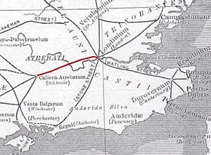
Calleva Atrebatum was an Iron Age oppidum, the capital of the Atrebates tribe. It then became a walled town in the Roman province of Britannia, at a major crossroads of the roads of southern Britain.

<span class="mw-page-title-main">Roman road from Silchester to Bath</span> Roman road in England

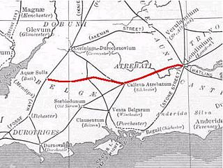
The Roman road from Silchester to Bath connected Calleva Atrebatum (Silchester) with Aquae Sulis (Bath) via Spinae (Speen), Cunetio and Verlucio. The road was a significant route for east–west travel and military logistics in south-east England during the 1st to 5th centuries.

<span class="mw-page-title-main">Little London, Tadley, Hampshire</span> Human settlement in England

Little London is a village situated between the North Hampshire Downs and the gravel plains of the Kennet valley, 7 miles (11 km) north of Basingstoke and 15 miles (24 km) south of Reading. It is situated within Pamber civil parish and backs on to Pamber Forest, a 500-acre (2.0 km2) SSSI and remnant of the much larger ancient Royal Forest of Pamber. It is recorded as having been established for at least 400 years.

<span class="mw-page-title-main">Roman roads in Britannia</span> Roads in the Province of Britannia, 43–410

Roman roads in Britannia were initially designed for military use, created by the Roman army during the nearly four centuries (AD 43–410) that Britannia was a province of the Roman Empire.

<span class="mw-page-title-main">Finchampstead</span> Human settlement in England

Finchampstead is a village and civil parish in the Wokingham Borough in the shire of Berkshire, England. Its northern extremity is 2 miles (3 km) south of Wokingham, 5 miles (8 km) west of Bracknell, 8 miles (13 km) south-east of Reading, and 34 miles (55 km) west of Central London. It is an affluent area, with the village ranking as Britain's 31st wealthiest. It has a high standard of living and is rated as one of the most desirable places to live in the United Kingdom.

<span class="mw-page-title-main">Ermin Way</span> Roman road that ran from Silchester to Gloucester, England

Ermin Street or Ermin Way was a Roman road in Britain. It linked Glevum (Gloucester) and Corinium (Cirencester) to Calleva (Silchester).

<span class="mw-page-title-main">Stratfield Saye</span>

Stratfield Saye is a small village and civil parish in the Borough of Basingstoke and Deane and the English county of Hampshire. The parish includes the hamlets of West End Green, Fair Oak Green and Fair Cross.

<span class="mw-page-title-main">Swinley Forest</span> Woodland in Southern England

Swinley Forest is a large expanse of Crown Estate woodland managed by Forestry England mainly within the civil parishes of Windlesham in Surrey and Winkfield and Crowthorne in Berkshire, England.

<span class="mw-page-title-main">Port Way</span> Roman road that ran from Calleva Atrebatum to Sorbiodunum

Port Way is an ancient road in southern England, which ran from Calleva Atrebatum in a south-westerly direction to Sorbiodunum. Often associated with the Roman Empire, the road may have predated the Roman occupation of Britain.

<span class="mw-page-title-main">Staines Bridge</span> Bridge across the River Thames in England

Staines Bridge is a road bridge running in a south-west to north-east direction across the River Thames in Surrey. It is on the modern A308 road and links the boroughs of Spelthorne and Runnymede at Staines-upon-Thames and Egham Hythe. The bridge is Grade II listed.

<span class="mw-page-title-main">Broadmoor to Bagshot Woods and Heaths</span>

Broadmoor to Bagshot Woods and Heaths is a 1,696.3-hectare (4,192-acre) biological Site of Special Scientific Interest (SSSI) in Berkshire and Surrey that extend from a minority of the parish of Crowthorne including around Broadmoor Hospital in the west to Bagshot south-east, Bracknell north-east, and Sandhurst, south. It is part of the Thames Basin Heaths Special Protection Area. Two nature reserves which are managed by the Surrey Wildlife Trust are in the SSSI, Barossa nature reserve and Poors Allotment. Broadmoor Bottom, which is part of Wildmoor Heath, also falls within the SSSI; this reserve is managed by the Berkshire, Buckinghamshire and Oxfordshire Wildlife Trust.

Devil's Highway or The Devil's Highway may refer to:

<span class="mw-page-title-main">Church Island, River Thames</span> Inhabited island in the River Thames in Surrey, England

Church Island or Church Eyot is an inhabited island in the River Thames in England on the reach above Penton Hook Lock in Staines-upon-Thames, Spelthorne, Surrey. It is in the upper part of the reach. It is approximately 200 m (660 ft) above Staines Bridge, but is thought by some historians to have been the site of the Roman bridges (Pontes) across the Thames recorded as a waypoint on the Devil's Highway between Londinium (London) and Calleva (Silchester).

<span class="mw-page-title-main">Lambourn Woodlands</span> Hamlet in England

Lambourn Woodlands is a hamlet in the English county of Berkshire. The village is situated in the civil parish of Lambourn, and is 2 miles (3.2 km) to the south of the village of Lambourn. The parish is within the unitary authority of West Berkshire, close to the border between the counties of Berkshire and Wiltshire.

<span class="mw-page-title-main">Woodlands St Mary</span> Village in England

Woodlands St Mary is a small village in the English county of Berkshire. The village is situated in the civil parish of Lambourn, and is 3 miles (4.8 km) to the south of the village of Lambourn, and 1 mile (1.6 km) from Lambourn Woodlands. The parish is within the unitary authority of West Berkshire, close to the border between the counties of Berkshire and Wiltshire.

<span class="mw-page-title-main">Ownham</span> Human settlement in England

Ownham is a hamlet in Berkshire, England, and part of the civil parish of Boxford.

Nine Mile Ride is a length of the B3430 road in the English county of Berkshire, running from the south of Bracknell to Finchampstead, in the Borough of Wokingham. Despite its name, the road is 6.7 miles (10.8 km) long. The western end is close to the California Country Park in California, Berkshire.

<span class="mw-page-title-main">Caesar's Camp, Bracknell Forest</span>

Caesar's Camp is an Iron Age hill fort around 2,400 years old. It is located just in Crowthorne civil parish to the south of Bracknell in the English county of Berkshire. It falls within the Windsor Forest and is well wooded, although parts of the fort have now been cleared of some trees. The area is managed by the Forestry Commission but owned by Crown Estate, and is open and accessible to the public. The hill fort covers an area of about 17.2 acres and is surrounded by a mile-long ditch, making it one of the largest in southern England.

<span class="mw-page-title-main">Ackling Dyke</span> Section of Roman road in England

Ackling Dyke is a section of Roman road in England which runs for 22 miles (35 km) southwest from Old Sarum (Sorviodunum) to the hill fort at Badbury Rings (Vindocladia). Part of the road on Oakley Down has been scheduled as an ancient monument.

References

  1. Lacey M. Wallace (8 January 2015). The Origin of Roman London. Cambridge University Press. p. 41. ISBN   978-1-107-04757-0.

Further reading