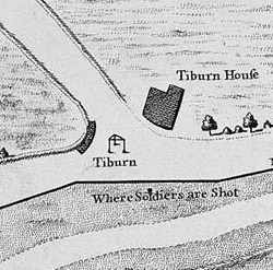
Tyburn was a manor (estate) in London, Middlesex, England, one of two which were served by the parish of Marylebone. Tyburn took its name from the Tyburn Brook, a tributary of the River Westbourne. The name Tyburn, from Teo Bourne, means 'boundary stream'.

Newgate Prison was a prison at the corner of Newgate Street and Old Bailey, just inside the City of London, England, originally at the site of Newgate, a gate in the Roman London Wall. Built in the 12th century and demolished in 1904, the prison was extended and rebuilt many times, and remained in use for over 700 years, from 1188 to 1902.

Holborn, an area in central London, covers the south-eastern part of the London Borough of Camden and a part of the Ward of Farringdon Without in the City of London.
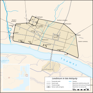
Londinium, also known as Roman London, was the capital of Roman Britain during most of the period of Roman rule. Most twenty-first century historians think that it was originally a settlement established shortly after the Claudian invasion of Britain, on the current site of the City of London around 47–50 AD, but some defend an older view that the city originated in a defensive enclosure constructed during the Claudian invasion in 43 AD. Its earliest securely-dated structure is a timber drain of 47 AD. It sat at a key ford at the River Thames which turned the city into a road nexus and major port, serving as a major commercial centre in Roman Britain until its abandonment during the 5th century.
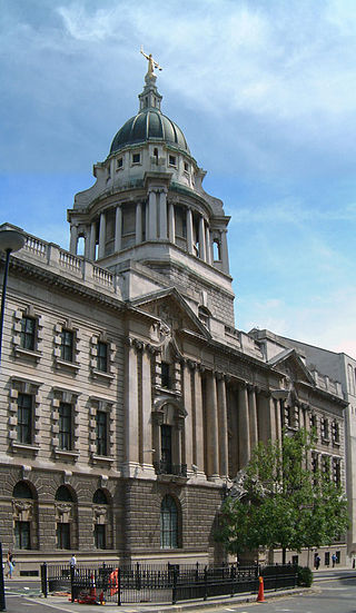
The Central Criminal Court of England and Wales, commonly referred to as the Old Bailey after the street on which it stands, is a criminal court building in central London, one of several that house the Crown Court of England and Wales. The street outside follows the route of the ancient wall around the City of London, which was part of the fortification's bailey, hence the metonymic name.

The London Wall is a defensive wall first built by the Romans around the strategically important port town of Londinium in c. AD 200, as well as the name of a modern street in the City of London, England.

Ludgate Hill is a street and surrounding area, on a small hill in the City of London, England. The street passes through the former site of Ludgate, a city gate that was demolished – along with a gaol attached to it – in 1760.

Holy Sepulchre London, formerly and in some official uses Saint Sepulchre-without-Newgate, is the largest Anglican parish church in the City of London. It stands on the north side of Holborn Viaduct across a crossroads from the Old Bailey, and its parish takes in Smithfield Market. During medieval times, the site lay outside ("without") the city wall, west of the Newgate.
George Dance the Younger RA was an English architect and surveyor as well as a portraitist.
The Castle, Newcastle, or Newcastle Castle is a medieval fortification in Newcastle upon Tyne, England, built on the site of the fortress that gave the City of Newcastle its name. The most prominent remaining structures on the site are the Castle Keep, and the Black Gate, its fortified gatehouse.

Oxford Castle is a large, partly ruined medieval castle on the western side of central Oxford in Oxfordshire, England. Most of the original moated, wooden motte and bailey castle was replaced in stone in the late 12th or early 13th century and the castle played an important role in the conflict of the Anarchy. In the 14th century the military value of the castle diminished and the site became used primarily for county administration and as a prison. The surviving rectangular St George's Tower is now believed to pre-date the remainder of the castle and be a watch tower associated with the original Saxon west gate of the city.

St Sepulchre was an ancient parish which had its southern part within the boundaries of the City of London and its northern part outside. Its former area is now within the contemporary neighbourhoods of Smithfield, Farringdon and Clerkenwell.
Montfichet's Tower was a Norman fortress on Ludgate Hill in London, between where St Paul's Cathedral and City Thameslink railway station now stand. First documented in the 1130s, it was probably built in the late 11th century. The defences were strengthened during the revolt of 1173–1174 against Henry II.

Farringdon Within is one of the 25 wards of the City of London, the historic and financial centre of London, England. It was formed in the 14th century from the sub-division of the pre-existing Farringdon Ward into Farringdon Within, and Farringdon Without, beyond the Wall.

Farringdon Without is the most westerly ward of the City of London, England. Its suffix Without reflects its origin as lying beyond the City's former defensive walls. It was first established in 1394 to administer the suburbs west of Ludgate and Newgate, including West Smithfield and Temple. This was achieved by splitting the very large, pre-existing Farringdon Ward into two parts, Farringdon Within and Farringdon Without. The large and prosperous extramural suburb of Farringdon Without has been described as having been London's first West End.

St. Martin's Le Grand is a former liberty within the City of London, and is the name of a street north of Newgate Street and Cheapside and south of Aldersgate Street. It forms the southernmost section of the A1 road. For many years St. Martin's Le Grand was "often used as a synonym for the chief postal authorities, as Scotland Yard is used to designate the police", the headquarters of the General Post Office having been there from 1829-1984.

The Church of St Andrew, Holborn, is a Church of England church on the northwestern edge of the City of London, on Holborn within the Ward of Farringdon Without.

St Nicholas Shambles was a medieval church in the City of London, which stood on the corner of Butcher Hall Lane and Newgate Street. It took its name from the Shambles, the butchers area in the west of Newgate Street. The church is first mentioned as St. Nicholas de Westrnacekaria. In 1253 Walter de Cantilupe, Bishop of Worcester granted indulgences to its parishioners.

Worcester Castle was a Norman fortification built between 1068 and 1069 in Worcester, England by Urse d'Abetot on behalf of William the Conqueror. The castle had a motte-and-bailey design and was located on the south side of the old Anglo-Saxon city, cutting into the grounds of Worcester Cathedral. Royal castles were owned by the king and maintained on his behalf by an appointed constable. At Worcester that role was passed down through the local Beauchamp family on a hereditary basis, giving them permanent control of the castle and considerable power within the city. The castle played an important part in the wars of the 12th and early 13th century, including the Anarchy and the First Barons' War.

Canterbury city walls are a sequence of defensive walls built around the city of Canterbury in Kent, England. The first city walls were built by the Romans, probably between 270 and 280 AD. These walls were constructed from stone on top of an earth bank, and protected by a ditch and wall towers. At least five gates were placed into the walls, linked to the network of Roman roads across the region. With the collapse of Roman Britain, Canterbury went into decline but the walls remained, and may have influenced the decision of Augustine to settle in the city at the end of the 6th century. The Anglo-Saxons retained the defensive walls, building chapels over most of the gates and using them to defend Canterbury against Viking incursions.


