
Long Valley Caldera is a depression in eastern California that is adjacent to Mammoth Mountain. The valley is one of the Earth's largest calderas, measuring about 20 mi (32 km) long (east-west), 11 mi (18 km) wide (north-south), and up to 3,000 ft (910 m) deep.

Inyo County is a county in the eastern central part of the U.S. state of California, located between the Sierra Nevada and the state of Nevada. In the 2020 census, the population was 19,016. The county seat is Independence. Inyo County is on the east side of the Sierra Nevada and southeast of Yosemite National Park in Central California. It contains the Owens River Valley; it is flanked to the west by the Sierra Nevada and to the east by the White Mountains and the Inyo Mountains. With an area of 10,192 square miles (26,397 km2), Inyo County is the second-largest county by area in California, after San Bernardino County. Almost one-half of that area is within Death Valley National Park. However, with a population density of 1.8 people per square mile, it also has the second-lowest population density in California, after Alpine County.

Siskiyou County is a county in the northernmost part of the U.S. state of California. As of the 2020 census, the population was 44,076. Its county seat is Yreka and its highest point is Mount Shasta. It falls within the Cascadia bioregion.

Mammoth Mountain is a lava dome complex partially located within the town of Mammoth Lakes, California, in the Inyo National Forest of Madera and Mono Counties. It is home to a large ski area primarily on the Mono County side.

The Devil's Punch Bowl is a 282.2-hectare (697-acre) visitor attraction and biological Site of Special Scientific Interest situated just to the east of the village of Hindhead in the English county of Surrey. It is part of the Wealden Heaths Phase II Special Protection Area.

Owens Valley is an arid valley of the Owens River in eastern California in the United States. It is located to the east of the Sierra Nevada, west of the White Mountains and Inyo Mountains, and north of the Mojave Desert. It sits on the west edge of the Great Basin. The mountain peaks on the West side reach above 14,000 feet (4,300 m) in elevation, while the floor of the Owens Valley is about 4,000 feet (1,200 m), making the valley the deepest in the United States. The Sierra Nevada casts the valley in a rain shadow, which makes Owens Valley "the Land of Little Rain." The bed of Owens Lake, now a predominantly dry endorheic alkali flat, sits on the southern end of the valley.
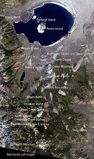
The Mono–Inyo Craters are a volcanic chain of craters, domes and lava flows in Mono County, Eastern California. The chain stretches 25 miles (40 km) from the northwest shore of Mono Lake to the south of Mammoth Mountain. The Mono Lake Volcanic Field forms the northernmost part of the chain and consists of two volcanic islands in the lake and one cinder cone volcano on its northwest shore. Most of the Mono Craters, which make up the bulk of the northern part of the Mono–Inyo chain, are phreatic volcanoes that have since been either plugged or over-topped by rhyolite domes and lava flows. The Inyo volcanic chain form much of the southern part of the chain and consist of phreatic explosion pits, and rhyolitic lava flows and domes. The southernmost part of the chain consists of fumaroles and explosion pits on Mammoth Mountain and a set of cinder cones south of the mountain; the latter are called the Red Cones.
Punchbowl is an alternative spelling of punch bowl, a large bowl for serving drinks, or may refer to:

The Owens River is a river in eastern California in the United States, approximately 183 miles (295 km) long. It drains into and through the Owens Valley, an arid basin between the eastern slope of the Sierra Nevada and the western faces of the Inyo and White Mountains. The river terminates at the endorheic Owens Lake south of Lone Pine, at the bottom of a 2,600 sq mi (6,700 km2) watershed.
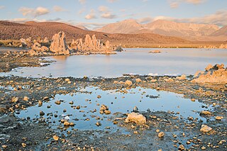
Mono Lake Tufa State Natural Reserve is located near Yosemite National Park within Mono County, in eastern California. It was established in 1981 by the California State Legislature to preserve the natural limestone "tufa tower" formations at Mono Lake.

Inyo National Forest is a United States National Forest covering parts of the eastern Sierra Nevada of California and the White Mountains of California and Nevada. The forest hosts several superlatives, including Mount Whitney, the highest point in the contiguous United States; Boundary Peak, the highest point in Nevada; and the Ancient Bristlecone Pine Forest, which protects the oldest living trees in the world. The forest, encompassing much of the Owens Valley, was established by Theodore Roosevelt as a way of sectioning off land to accommodate the Los Angeles Aqueduct project in 1907, making the Inyo National Forest one of the least wooded forests in the U.S. National Forest system.

Umpqua National Forest, in southern Oregon's Cascade Range, covers an area of 983,129 acres (3,978.58 km2) in Douglas, Lane, and Jackson counties, and borders Crater Lake National Park. The four ranger districts for the forest are the Cottage Grove, Diamond Lake, North Umpqua, and Tiller ranger districts. The forest is managed by the United States Forest Service, headquartered in Roseburg.

Devil's Punchbowl is a tilted sandstone formation on the northern slopes of the San Gabriel Mountains, in Los Angeles County, California, at an elevation of 4,750 feet (1,450 m).

A punch bowl or punchbowl is a bowl, often large and wide, in which the drink punch is served.

Devils Punch Bowl State Natural Area is a state day use park on the central Oregon Coast in the United States. It is centered on a large bowl naturally carved in a rock headland which is partially open to the Pacific Ocean. Waves enter the bowl and often violently churn, swirl, and foam. Outside the bowl, ocean conditions are attractive to surfers near a large offshore rock pinnacle named Gull Rock, located about 1⁄2 mile (800 m) west-northwest of Devils Punch Bowl, which funnels and concentrates waves easily seen from the park. There are at least seventeen large rocks, part of Oregon Islands National Wildlife Refuge, which provide interesting wave viewing, and attract and provide a home for wildlife.
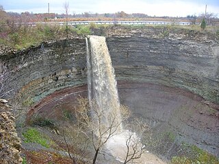
Devil's Punch Bowl is a 37-metre ribbon waterfall on the Niagara Escarpment, in the Stoney Creek community of Hamilton, Ontario, Canada. It is found in the Devil's Punchbowl Conservation Area, maintained by the Hamilton Conservation Authority, and features an escarpment access trail with connections to a recently improved section of the Bruce Trail. Stoney Creek's Dofasco 2000 Trail is nearby. The Punch Bowl is also known as Horseshoe Falls for the distinctive shape of the cliff-face, which somewhat resembles its much larger cousin in Niagara Falls.

The Punchbowl Formation is a sedimentary sandstone geologic formation in the northern San Gabriel Mountains, above the Antelope Valley in Los Angeles County, southern California.
The protected areas of the Sierra Nevada, a major mountain range located in the U.S. states of California and Nevada, are numerous and highly diverse. Like the mountain range itself, these areas span hundreds of miles along the length of the range, and over 14,000 feet of elevation from the lowest foothills to the summit of Mount Whitney.