
The Peak District is an upland area in England at the southern end of the Pennines. Mostly in Derbyshire, it extends into Cheshire, Greater Manchester, Staffordshire, West Yorkshire and South Yorkshire. It includes the Dark Peak, where moorland is found and the geology gritstone, and the White Peak, a limestone area with valleys and gorges. The Dark Peak forms an arc on the north, east and west sides; the White Peak covers central and southern tracts. The historic Peak District extends beyond the National Park, which excludes major towns, quarries and industrial areas. It became the first of the national parks of England and Wales in 1951. Nearby Manchester, Stoke-on-Trent, Derby and Sheffield send millions of visitors – some 20 million live within an hour's ride. Inhabited from the Mesolithic era, it shows evidence of the Neolithic, Bronze and Iron Ages. Settled by the Romans and Anglo-Saxons, it remained largely agricultural; mining arose in the Middle Ages. Richard Arkwright built cotton mills in the Industrial Revolution. As mining declined, quarrying grew. Tourism came with the railways, spurred by the landscape, spa towns and Castleton's show caves.
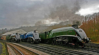
The North Yorkshire Moors Railway (NYMR) is a heritage railway in North Yorkshire, England, that runs through the North York Moors National Park. First opened in 1836 as the Whitby and Pickering Railway, the railway was planned in 1831 by George Stephenson as a means of opening up trade routes inland from the then important seaport of Whitby. The line between Grosmont and Rillington was closed in 1965 and the section between Grosmont and Pickering was reopened in 1973 by the North York Moors Historical Railway Trust Ltd. The preserved line is now a tourist attraction and has been awarded several industry accolades.

The North York Moors is an upland area in north-eastern Yorkshire, England. It contains one of the largest expanses of heather moorland in the United Kingdom. The area was designated as a National Park in 1952, through the National Parks and Access to the Countryside Act 1949. Covering an area of 554 sq mi (1,430 km2), the National Park has a population of 23,380. It is administered by the North York Moors National Park Authority, whose head office is based in Helmsley.

Guisborough is a market town and civil parish in the borough of Redcar and Cleveland, North Yorkshire, England. It lies north of the North York Moors National Park. Roseberry Topping, midway between the town and Great Ayton, is a landmark in the national park. At the 2011 census, the civil parish with outlying Upleatham, Dunsdale and Newton under Roseberry had a population of 17,777, of which 16,979 were in the town's built-up area. It was governed by an urban district and rural district in the North Riding of Yorkshire.

The Pennines, also known as the Pennine Chain or Pennine Hills, are a more-or-less continuous range of hills and mountains running between three regions of Northern England: North West England on the west, and North East England and Yorkshire and the Humber on the east. Commonly described as the "backbone of England", the range stretches northwards from the Peak District at the southern end, through the South Pennines, the Yorkshire Dales and North Pennines to the Tyne Gap, which separates the range from the Cheviot Hills across the Anglo-Scottish border. South of the Aire Gap is a western spur into east Lancashire, comprising the Rossendale Fells, West Pennine Moors and the Bowland Fells in North Lancashire. The Howgill Fells and Orton Fells in Cumbria are sometimes considered to be Pennine spurs to the west of the range. The Pennines are an important water catchment area with numerous reservoirs in the head streams of the river valleys.

Jackson Hole is a valley between the Gros Ventre and Teton mountain ranges in the U.S. state of Wyoming, near the border with Idaho. The term "hole" was used by early trappers, or mountain men, as a term for a large mountain valley. These low-lying valleys, surrounded by mountains and containing rivers and streams, are good habitat for beavers and other fur-bearing animals. Jackson Hole is 55 miles (89 km) long by 6-to-13 miles (10-to-21 km) wide and is a graben valley with an average elevation of 6,800 ft, its lowest point being near the southern park boundary at 6,350 ft.
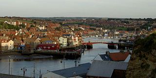
The River Esk is a river in North Yorkshire, England that empties into the North Sea at Whitby after a course of around 28 miles (45 km) through the valley of Eskdale, named after the river itself. The river's name is derived from the Brythonic word "isca" meaning "water". The Esk is the only major river in Yorkshire that flows directly into the North Sea; all other watercourses defined as being major rivers by the Environment Agency, either flow to the North Sea via the River Tees or the Humber Estuary.

Levisham railway station is a station on the North Yorkshire Moors Railway and serves the village of Levisham in the North York Moors National Park, North Yorkshire, England.

Newton Dale Halt railway station is a request stop on the North Yorkshire Moors Railway and serves as a stopping off point for walkers around Newton Dale and Cropton Forest in the North York Moors National Park, North Yorkshire, England. When the station was opened, the station signs were written as Newtondale Halt.

Hutton-le-Hole is a small village and civil parish in the Ryedale district of North Yorkshire, England, about 7 miles (11 km) north-west of Pickering. It is a popular scenic village within the North York Moors National Park. Sheep roam the streets at will.
Levisham is a small village and civil parish in the Ryedale district of North Yorkshire, England, located within the North York Moors National Park about 5 miles (8 km) north of Pickering. At the 2011 Census the population was less than 100. Details are included in the civil parish of Lockton.

Lockton is a small village and civil parish in the Ryedale district of North Yorkshire, England. It is situated in the North York Moors about 4 miles (6.4 km) north-east of Pickering. Nearby villages include Newton-on-Rawcliffe and Levisham. The village is often used as a base by tourists visiting the nearby Dalby Forest.

Beck Hole is a small valley village in the Borough of Scarborough, North Yorkshire, England. The village lies within the Goathland civil parish and the North York Moors national park.

The South Pennines is a region of moorland and hill country in northern England lying towards the southern end of the Pennines. In the west it includes the Rossendale Valley and the West Pennine Moors. It is bounded by the Greater Manchester conurbation in the west and the Bowland Fells and Yorkshire Dales to the north. To the east it is fringed by the towns of West Yorkshire whilst to the south it is bounded by the Peak District. The rural South Pennine Moors constitutes both a Site of Special Scientific Interest and Special Area of Conservation.

Farndale is a valley and community in Ryedale district, North Yorkshire, England, which is known for the daffodils which flower each spring along a 7-mile (11 km) stretch of the River Dove. The valley is in the North York Moors National Park, some 11 miles (18 km) north of Kirkbymoorside, the nearest town. Pickering is some 17 miles (27 km) to the south-east and Helmsley 17 miles (27 km) to the south-west.

The Geology of Yorkshire in northern England shows a very close relationship between the major topographical areas and the geological period in which their rocks were formed. The rocks of the Pennine chain of hills in the west are of Carboniferous origin whilst those of the central vale are Permo-Triassic. The North York Moors in the north-east of the county are Jurassic in age while the Yorkshire Wolds to the south east are Cretaceous chalk uplands. The plain of Holderness and the Humberhead levels both owe their present form to the Quaternary ice ages. The strata become gradually younger from west to east.

The Tabular Hills form an east–west line along the southern bounds of the North York Moors, between Scarborough in the east and Black Hambleton in the west. The name refers to their flat summits composed of hard Corallian limestone, known locally as "nabs". They form the northern boundary of the Vale of Pickering.

The A169 is an A road in North Yorkshire, England. It runs from the A64 at Malton on the edge of the Yorkshire Wolds through the Vale of Pickering and across the North York Moors to join the A171 just west of Whitby. It is a single carriageway for all of its 25-mile (40 km) route. Whilst it is not considered a Primary Route nationally, the Ryedale Local Transport Plan lists it as part of its Major Road Network alongside the A64, A166 and A171.

Newton Dale is a narrow dale within the North York Moors National Park in North Yorkshire, England. It was created by meltwater from a glacier carving the narrow valley. Water still flows through the dale and is known as Pickering Beck.


