
Godhra is a municipality in Panchmahal district in Indian state of Gujarat. It is the administrative headquarters of the Panchmahal district. Originally the name came from gou which means "cow" and dhara- which have two meanings depending on how you pronounce the word: 'dharaa' means a feminine thing or person that "holds" something and it usually means"land", and the other pronunciation is 'dhaaraa' in which means "flow". However, the second pronunciation is not popular nor is usually associated with this word. Hence, 'Godhra or Godharaa' means the Land of the Cow.
Kheda is a city and a municipality in the Indian state of Gujarat. It was former administrative capital of Kheda district. India's First Deputy Prime Minister Vallabhbhai Patel Was Born In Kheda District of Gujarat State. Kheda city is famous for tobacco farming. The nearest railway station is Mahemadavad Kheda Road. The nearest airport is Ahmedabad airport. The nearest bus station is Kheda Bus Station.
Dholka is a city and municipality in the Ahmedabad District of the Indian state of Gujarat. It is the headquarters of Dholka Taluka, and is 48 km by road via National Highway 8A southwest of the city of Ahmedabad. Dholka has an average elevation of 17 metres (56 ft).

Motera is a neighbourhood in the northwestern part of the metropolis of Ahmedabad in Gujarat, India. It lies west of the Sabarmati River. It falls under the West Zone of Ahmedabad Municipal Corporation and under the Gandhinagar South constituency of Gujarat Legislative Assembly and under the Gandhinagar constituency of the Lok Sabha. The chief attraction in Motera is the world's largest sports stadium, Narendra Modi Stadium. The stadium is the venue for the international cricket matches held in Ahmedabad. In 2015, old stadium was demolished and new stadium was built which got the honour of world's largest stadium.

Ahmedabad district or Amdavad district, is a district comprises the city of Amdavad, in the central part of the state of Gujarat in western India. It is the seventh most populous district in India.
Dhrangadhra is a town, taluka headquarters and a municipality in Surendranagar district in the state of Gujarat, India. During the period of the British Raj, the city was the capital of Dhrangadhra State, one of the eight first-class princely states of the Kathiawar Agency in the Bombay Presidency.

Adalaj is a census town in Gandhinagar district located in the western Indian state of Gujarat. With a population of roughly 12,000 residents within the town limits as of 2011, Adalaj is known for its semi-arid climate and its historic and religious establishments. The town sits in a generally flat area covering about 18 sq. km.
Chalala is a town and a municipality in Amreli district in the state of Gujarat, India.
Chanasma is a small town and a municipality in Chanasma Taluka of Patan district in the state of Gujarat, India. Chanasma is a seat of Gujarat Assembly. The MP seat of Chanasma falls in the Patan Lok Sabha. Chanasma village is connected by Kandla-Mehsana highway. And since the broad gauge of the railway is being renovated, it is going to connect with Rajasthan via Patan from Ahmedabad. Patel, Brahmin, Vania, Darji, Panchal, Parmar, Rabari, Thakor, Nayi, all communities live in Chansma village. The old village of Chanasma was between Ugmano Darwaza and Athamano Darwaza. But now due to the increase in population and development of the village, the village is spreading to the outside. Chansma Village Shree Laljidas Laxmidas Patel Trust runs Rotla Ghar for feeding the poor where clean and nutritious meals are provided to the poor for free.
Gadhada is a town and a municipality in Botad District in the state of Gujarat, India. Gadhada is situated at bank of River Ghela. Swaminarayan lived here for more than 25 years.
Lambha is a census town in Ahmadabad district in the Indian state of Gujarat. Parts of Vejalpur, Daskroi, Danilimda, Vatva, and Maninagar assembly constituencies jut into Lambha. Many parts of Kheda, Gandhinagar, Ahmedabad West, and Ahmedabad East Lok Sabha constituencies fall in Lambha.

Talaja is a town and a municipality in Bhavnagar district in the Indian state of Gujarat.
Una is a town and a municipality in Gir Somnath district of the Saurashtra region in the state of Gujarat, India.
Devrajiya is a village in the Amreli district of India. Devrajiya was under the control of the Amreli state during the Navabshahi.Local business mainly consists of agriculture and diamonds.

The Bhal region is an area of Gujarat, India. It is spread across the political boundaries of the districts of Bhavnagar, Ahmedabad, and Anand. The Bhal region is situated on the deltas of the Sabarmati, Bhogawo, Bhadar, Lilka and other rivers that flow east and southeast off the Kathiawar peninsula into the Gulf of Cambay. The word Bhaal seems to have been derived from the Sanskrit word भाल which means forehead. Such a name is given to this region probably because it is mostly as flat as a forehead with almost entire region's soil without any stones, pebbles or gravel.
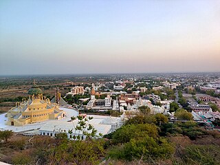
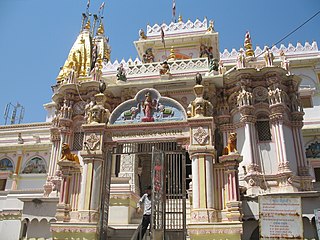
Pālītāṇā is a city in Bhavnagar district, Gujarat, India. It is located 50 km southwest of Bhavnagar city and is a major pilgrimage centre for Jains. It is first of the two vegetarian cities in the world.
Raliyana is a village in Botad district in the state of Gujarat, India. Raliyana is situated on the bank of the River Ghelo.
Chamardi is a large village located within the Vallabhipur Taluka township of the Bhavnagar district (Gujarat), in West India. It was formerly a part of Rajput princely state.
Vihal Krupa is a Home in Raliyana in the state of Gujarat, India. Vihal Krupa is situated on the bank of the River Ghelo.
Songadh is a census town in Bhavnagar district of Saurashtra in Gujarat, India. As of the 2011 Census of India, it had a population of 6,027 across 1252 households. It is 8 km from Sihor town and 28 km from Bhavnagar town. The Songadh Jain temple is a notable landmark in the town.


