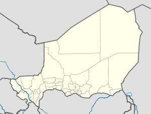
Niger is a landlocked nation in West Africa located along the border between the Sahara and Sub-Saharan regions. Its geographic coordinates are longitude 16°N and latitude 8°E. Its area is 1.267 million square kilometers, of which 1 266 700 km² is land and 300 km² water, making Niger slightly less than twice the size of France.

Niamey is the capital and largest city of Niger. Niamey lies on the Niger River, primarily situated on the east bank. Niamey's population was counted as 1,026,848 as of the 2012 census. As of 2017, population projections show the capital district growing at a slower rate than the country as a whole, which has the world's highest fertility rate.

Ayourou is a town and rural commune in the Tillabéri Region, in western Niger. It is situated 208 km northwest of the capital Niamey near the Malian border. The old town stands on an eponymous island in the River Niger. It is known for its animal market and for wildlife including hippopotamuses and birds.
Tillabéri is a town in northwest Niger. It is situated 113 km northwest of the capital Niamey on the River Niger. It is an important market town and administrative center, being the capital of department of Tillabéri and Tillabéri Region. The town had a population of over 16000 at the 2001 census.

Tillabéri is one of the eight Regions of Niger; the capital of the Region is Tillabéri. Tillabéri Region was created in 1992, when Niamey Region was split, with Niamey and its immediate hinterland becoming a new capital district enclaved within Tillabéri Region.
Téra is a city in the Tillabéri Region, Tera Department of Niger. It is situated 175 km north-west of the capital Niamey, close to the border with Burkina Faso. It is mainly inhabited by Songhai, Fulani, Gourmantche and Buzu ethnic groups. The majority of the population are farmers.
Say (Saayi) is a town in southwest Niger, situated on the Niger River. It is the capital of the Say Department in the Tillabéri Region. Say is believed to be situated at the exact same location as "Lulami", the last capital of the Songhai Empire after its invasion by the Saadi Dynasty of Morroco and one of the places where the Askia princes settled.
Ouallam is a town around 90 km north of Niamey in southwestern Niger. It is the capital of Ouallam Department, one of four departments in the Tillabéri Region.
Bani-Bangou is a town in southwestern Niger, in rural northern Ouallam Department, Tillabéri Region. It is the capital of the rural commune of Bani-Bangou. On the main highway from Ouallam on the route to the Malian border town of Andéramboukane. It is 135 km northeast of Ouallam and 70 km by road from Mali. It around 200 km cross country from Niamey. The town is the seat of a "Rural Commune" of the same name, one of four rural communes in the Department. Nearby villages include Gorou, Bassikwana, and Tondi Tiyaro Kwara to the north; Koloukta and Dinara along the highway west; Ouyé to the southeast.
The following outline is provided as an overview of and topical guide to Niger:

Niger is divided into seven regions, each named after its capital.

Say is a department of the Tillabéri Region in Niger. Its capital city is Say, and includes the towns of Guéladjo, Tamou, and Torodi. It abuts the urban Region of Niamey, and lies across the Niger River to the southwest of the capital. It extends to the Burkina Faso border over 60 km to the west, and the northernmost border with Benin in the south. The Say area is today divided between the riverine valley in the east of the Department, and the more sparsely populated areas to the west, which are intercut with a series of eastward flowing tributaries. The Niger river, a broad shallow channel at Niamey and at Say, passes through a series of gorges and cataracts, called the "W" bend for the shape the river takes, in the south of the Say Department. To the west of these rapids lies what is now the W Regional Park, a sparsely populated area historically plagued by insect borne diseases of both humans and cattle. Now a park and tourist attraction, its history as a "no mans land" has made it a refuge for remaining wild animals, as well as several undisturbed archeological sites. From at least the 16th century CE, the Zarma people moved south into this area from the northern plateau around what is now Oullam. The inhabitants at the time were related to the Gourma people, who form most of the population of the northwestern part of the Department today. In the 18th and 19th century, the town of Say was founded by Fulani migrants from the Gao region of modern Mali, with others expanding from what is now northeast Burkina Faso. Between 1810 and the arrival of European writer Heinrich Barth in 1854, Fulani Muslims led by Alfa Mohamed Diobo of Djenné had established the Emirate of Say. The reputation for piety and learning of Mohamed Diobo and his followers helped turn Say from a small river village into a town of 30,000, famed across West Africa as a center of learning.
Téra is a department of the Tillabéri Region in Niger. Its capital lies at the city of Téra. As of 2011, the department had a total population of 579,658 people.

Niger is governed through a four layer, semi-decentralised series of Administrative divisions. Begun 1992, and finally approved with the formation of the Fifth Republic of Niger on 18 July 1999, Niger has been enacting a plan for Decentralisation of some state powers to local bodies. Prior to the 1999-2006 project, Niger's subdivisions were administered via direct appointment from the central government in Niamey. Beginning with Niger's first municipal elections of 2 February 1999, the nation started electing local officials for the first time. Citizens now elect local committee representatives in each Commune, chosen by subdivisions of the commune: "Quarters" in towns and "Villages" in rural areas, with additional groupings for traditional polities and nomadic populations. These officials choose Mayors, and from them are drawn representatives to the Department level. The same process here chooses a Departmental council and Prefect, and representatives to the Regional level. The system is repeated a Regional level, with a Regional Prefect, council, and representatives to the High Council of Territorial Collectives. The HCCT has only advisory powers, but its members have some financial, planning, educational and environmental powers. The central government oversees this process through the office of the Minister of State for the Interior, Public Safety and Decentralization.

Kollo is a large town and urban commune in southwestern Niger, where NGOs work, as well as, missionaries and Peace Corps volunteers. It lies in the Kollo Department of the Tillabéri Region.
Tamou is a village and "Rural commune" in Niger. The town is capital of its Rural Commune in the Say Department of Tillabéri Region, in the far southwest of the nation. It is southwest of Niamey, on the right (western) bank of the Niger River, between the departmental capital Say and the border of Burkina Faso. Tamou Commune is home to the Tamou Total Reserve, a wildlife reserve which is part of the larger W National Park and Transborder Reserve. The Tamou Reserve, in which local people also live, is primarily dedicated to the protection of African Elephant populations which migrate through the region.
Torodi is a small town and a rural commune in Niger. As a rural center, Torodi hosts a large weekly market and the seat of local tribal authority (canton). Torodi is in the Say Department of the Tillaberi Region, which surrounds the national capital, Niamey. Say Department, with its capital at the large Niger River town of Say, abuts Niamey to the southwest and across the river to the west. The town of Torodi lies about 60 km due west of the city of Say and 50 km east of the border with Burkina Faso. Torodi itself lies on a tributary of the Niger, the Gourbi river.
The following is a timeline of the history of the city of Niamey, Niger.
This article lists events from the year 2020 in Niger.
Balléyara is a town in the Tillabéri Region of Niger. In 1988 the population was 6,042 in 1,058 households. In 2001 the population was 10,868 in 1,261 households, and in 2012 the population was 16,063, with 2,375 households.