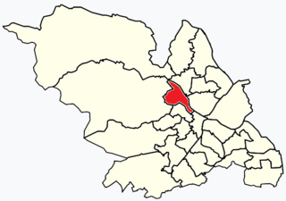
Hillsborough is an electoral ward which includes the districts of Malin Bridge, Owlerton, Wadsley and Wisewood. It is one of the 28 electoral wards in City of Sheffield, England. It is located in the northwestern part of the city and covers an area of 4.6 km2. The population of this ward in 2011 was 18,605 people in 8,012 households.

Worrall is a small rural village in the civil parish of Bradfield, South Yorkshire, England, 4 miles (6.5 km) north west of Sheffield city centre. It has an area of 233 hectares, and population of 1,306 as of 2006, and borders the Sheffield suburbs of Wadsley, Middlewood and Loxley to the south and east and the adjoining village of Oughtibridge to the north; to the west is a rural area extending towards the village of High Bradfield.

Whirlow is a suburb of the City of Sheffield in England, it lies 3.7 miles (6 km) south-west of the city centre. The suburb falls within the Dore and Totley ward of the City. It is one of the most affluent areas of Sheffield, with much high class housing and several notable small country houses within it. During the Victorian era it was home to some of Sheffield's most influential citizens. Whirlow straddles the A625, the main Sheffield to Hathersage road. The suburb covers the area from Parkhead in the north to Whirlow Bridge in the south and from Ecclesall Woods in the east to Broad Elms Lane in the west. Whirlow had a population of 1,663 in 2011.
Wadsley Bridge is a suburb of Sheffield, South Yorkshire, England, 3 miles (4.8 km) northwest of the city centre. The area is a mixture of residential housing and small industrial and commercial premises. The suburb falls within the Hillsborough ward of the City.
Wadsley is a suburb of the City of Sheffield in South Yorkshire, England. It stands 3 miles (5 km) north-west of the city centre at an approximate grid reference of SK321905. At the 2011 Census the suburb fell within the Hillsborough ward of the City. Wadsley was formerly a rural village which was engulfed by the expansion of Sheffield in the early part of the 20th century.

Loxley is a village and a suburb of the city of Sheffield, England. It is a long linear community which stretches by the side of the River Loxley and along the B6077 for almost 2.5 miles (4 km). Loxley extends from its borders with the suburbs of Malin Bridge and Wisewood westward to the hamlet of Stacey Bank near Damflask Reservoir. The centre of the suburb is situated at the junction of Rodney Hill and Loxley Road where the old village green stands and this is located 3 miles (5 km) north west of Sheffield city centre. The suburb falls within the Stannington ward of the City of Sheffield.

Oughtibridge is a residential village in the north of Sheffield within the bounds of Bradfield civil parish. The village stands 5 miles (8 km) north-west of the city centre in the valley of the River Don. The population of the village has increased significantly in recent years due to much private housing development and stood at 3,542 in 2006 over an area of 355 hectares. The population of Oughtibridge increased to 3,584 in 2011.

Firth Park ward—which includes the districts of Firth Park, Longley, Parson Cross and parts of Wincobank—is one of the 28 electoral wards in City of Sheffield, England located in the northern part of the city and covering an area of 1.66 square miles (4.3 km2). The population of this ward in 2011 was 21,141 people in 8,602 households.
Middlewood is a north western suburb of Sheffield, South Yorkshire, England. The suburb falls within the Stannington ward of the City.
Hillsborough is a suburb in north-west Sheffield, South Yorkshire, England. The centre of the district is popularly thought to be 'Hillsborough Corner' where Langsett Road, Middlewood Road, Holme Lane and Bradfield Road all meet. The Hillsborough ward population at the 2011 Census was 18,605.
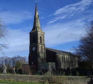
Wadsley Parish Church is situated within the city of Sheffield, South Yorkshire, England. It is located on Worrall Road, 3 miles (5 km) north west of the city centre in the suburb of Wadsley, which was formerly a village outside the city boundary. The church is quite unusual in that it is not dedicated to a saint. It is a grade II listed building.
Arthur Edward Catlin was a footballer who played his entire professional career for Sheffield Wednesday. He was a strong tackling left back who made 230 appearances for Wednesday between 1931 and 1939. He also played for the England national football team on five occasions. Catlin never scored a goal in an official match in his 8+1⁄2-year career at Hillsborough although he did score in the wartime league game against Notts County in 1944 which Wednesday won 6–1.
Jack Whitham is an English former professional footballer who played for Sheffield Wednesday, Liverpool, Cardiff City and Reading. He was a centre forward who only started 111 league games in a nine-year career between 1967 and 1976, scoring 40 goals. He made one appearance for the England under 23 team against Wales in 1968.
Wisewood is a suburb of the city of Sheffield in South Yorkshire, England and situated 2+3⁄4 miles (4.4 km) north-west of the city centre. It is a residential suburb consisting almost exclusively of council housing, some of which has been bought by tenants under the right to buy scheme. It is bordered by the adjacent suburbs of Loxley, Wadsley, Malin Bridge and Hillsborough.

Whitley Hall is a 16th-century mansion which since 1969 has been converted into a restaurant and then a hotel. It is situated in the northern rural district of the City of Sheffield in South Yorkshire, England. The small hamlet of Whitley lies in the countryside between the suburbs of Grenoside, Chapeltown and Ecclesfield some 7.5 km (4.7 mi) north of the city centre. The hall is a Grade II* listed building.

Endcliffe Hall is a 19th-century, 36-room mansion situated on Endcliffe Vale Road in the City of Sheffield in the suburb of Endcliffe. The hall is situated just over three km west of the city centre and is a Grade II* Listed building.

Middlewood Hospital is a former psychiatric hospital situated between the suburbs of Middlewood and Wadsley in the City of Sheffield, South Yorkshire, England. It was also known as the South Yorkshire Asylum (1872–1888), the West Riding Asylum, Wadsley (1889–1929) and Wadsley Mental Hospital (1930–1948). It was one of four hospitals that made up The West Riding General Asylums Committee. It closed in 1996 and is now a private housing development called Wadsley Park Village.
Gleadless Valley is a housing estate and electoral ward of the City of Sheffield in England. The population of the ward at the 2011 Census was 21,089. It lies 2.5 miles (4.0 km) south-southeast of the city centre. Formerly a rural area, Gleadless Valley was developed as a large housing project with around 4000 dwellings by Sheffield City Council between 1955 and 1962. It is an area of undulating land drained by the Meers Brook, which has its source on the high ground in the woodland at Gleadless. Adjacent are Gleadless to the east, Norton to the south-west, Heeley to the west and Arbourthorne to the north.

Parkhead Hall, formerly Parkhead House and The Woodlands, is an English country house situated in the City of Sheffield in South Yorkshire. The hall is a grade II listed building and is located in the suburb of Whirlow close to the junction of Ecclesall Road South and Abbey Lane. The hall is difficult to view for the general public, being surrounded by high walls and housing, although a glimpse of its northern side can be seen from Ecclesall Road South.
Leader House is a Georgian townhouse located on Surrey Street in the city centre of Sheffield, England. It overlooks the busy Arundel Gate dual carriageway and is a Grade II listed building.

