Diamond lane

Last updated
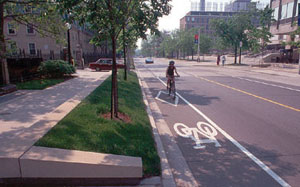
A rider in a bicycle diamond lane Bike-diamond-lane.jpg
A rider in a bicycle diamond lane

In the United States and Canada, a diamond lane is a special lane on a street or highway that is reserved for specific types of traffic. These lanes are usually marked with white diamonds or lozenge, hence their name. Diamond lanes are generally the right-most or left-most lane on the road. They are usually implemented to provide ways through traffic congestion, for safety reasons, and to encourage environmentally friendly transportation. A diamond lane may be intended for a specific type of traffic, or for several types. The intended use of a diamond lane is marked by traffic signs. In most areas, violating the rules of a diamond lane is punishable by a fine.

Contents

Some common examples are:

In some cases, these lanes may serve multiple functions. For example, a diamond lane may be designated for buses, bicycles, and right turns.

Standards

The Federal Highway Administration's Manual on Uniform Traffic Control Devices states that diamonds indicates a lane reserved for high-occupancy vehicles. [1]

See also

Related Research Articles

Traffic Road users travelling by foot or vehicle

Traffic on roads consists of road users including pedestrians, ridden or herded animals, vehicles, streetcars, buses and other conveyances, either singly or together, while using the public way for purposes of travel.

Highway A public road or other public way on land

A highway is any public or private road or other public way on land. It is used for major roads, but also includes other public roads and public tracks: It is not an equivalent term to controlled-access highway, or a translation for autobahn, autoroute, etc.

High-occupancy vehicle lane Restricted traffic lane

A high-occupancy vehicle lane is a restricted traffic lane reserved for the exclusive use of vehicles with a driver and one or more passengers, including carpools, vanpools, and transit buses. These restrictions may be only imposed during peak travel times or may apply at all times. According to the criteria used there are different types of lanes: temporary or permanent with concrete barriers; two-directional or reversible; and exclusive, concurrent or contraflow lanes working in peak periods. The normal minimum occupancy level is 2 or 3 occupants. Many jurisdictions exempt other vehicles, including motorcycles, charter buses, emergency and law enforcement vehicles, low-emission and other green vehicles, and/or single-occupancy vehicles paying a toll. HOV lanes are normally created to increase average vehicle occupancy and persons traveling with the goal of reducing traffic congestion and air pollution, although their effectiveness is questionable.

Rush hour

A rush hour or peak hour is a part of the day during which traffic congestion on roads and crowding on public transport is at its highest. Normally, this happens twice every weekday; once in the morning and once in the afternoon or evening, the times during which the most people commute. The term is often used for a period of peak congestion that may last for more than one hour.

Shoulder (road) Reserve lane by the verge of a roadway

A shoulder, or hard shoulder, is an emergency stopping lane by the verge of a road or motorway, on the right side in countries which drive on the right, and on the left side in countries which drive on the left. Many wider U.S. freeways have shoulders on both sides of each directional carriageway—in the median, as well as at the outer edges of the road, for additional safety. Shoulders are not intended for use by through traffic, although there are exceptions.

Lane

In road transport, a lane is part of a carriageway that is designated to be used by a single line of vehicles to control and guide drivers and reduce traffic conflicts. Most public roads (highways) have at least two lanes, one for traffic in each direction, separated by lane markings. On multilane roadways and busier two-lane roads, lanes are designated with road surface markings. Major highways often have two multi-lane roadways separated by a median.

A wide outside lane (WOL) or wide curb lane (WCL) is an outermost lane of a roadway that is wide enough to be safely shared side by side by a bicycle and a wider motor vehicle at the same time. The terms are used by cyclists and bicycle transportation planners in the United States. Generally, the minimum-width standard for a WOL in the US is 14 feet. A wide outside through lane (WOTL) is a WOL that is intended for use by through traffic.

In transport engineering nomenclature, a counterflow lane or contraflow lane is a lane in which traffic flows in the opposite direction of the surrounding lanes.

Road signs in the United Kingdom

Road signs in the United Kingdom and in its associated Crown dependencies and overseas territories conform broadly to European design norms, though a number of signs are unique: direction signs omit European route numbers and road signs generally use the Imperial System of units, unlike the rest of Europe.

Road diet Transportation planning technique

A road diet, also called a lane reduction or road rechannelization, is a technique in transportation planning whereby the number of travel lanes and/or effective width of the road is reduced in order to achieve systemic improvements.

Cycling in the Netherlands

Cycling is a common mode of transport in the Netherlands, with 36% of the people listing the bicycle as their most frequent mode of transport on a typical day as opposed to the car by 45% and public transport by 11%. Cycling has a modal share of 27% of all trips nationwide. In cities this is even higher, such as Amsterdam which has 38%, and Zwolle 46%. This high frequency of bicycle travel is enabled by excellent cycling infrastructure such as cycle paths, cycle tracks, protected intersections, ample bicycle parking and by making cycling routes shorter, quicker and more direct than car routes.

Queue jump

A queue jump is a type of roadway geometry used to provide preference to buses at intersections, often found in bus rapid transit systems. It consists of an additional travel lane on the approach to a signalised intersection. This lane is often restricted to transit vehicles only. A queue jump lane is usually accompanied by a signal which provides a phase specifically for vehicles within the queue jump. Vehicles in the queue jump lane get a "head-start" over other queued vehicles and can therefore merge into the regular travel lanes immediately beyond the signal. The intent of the lane is to allow the higher-capacity vehicles to cut to the front of the queue, reducing the delay caused by the signal and improving the operational efficiency of the transit system.

Road signs in Iceland

Road signs in Iceland conform to the general pattern of those used in most other European countries, with certain design elements borrowed from Danish and Swedish practice. Signs tend to be more sparsely employed than in other European countries, especially in rural areas.

Road signs in the United States Road / traffic signs utilized in the United States

In the United States, road signs are, for the most part, standardized by federal regulations, most notably in the Manual on Uniform Traffic Control Devices (MUTCD) and its companion volume the Standard Highway Signs (SHS).

Cycling infrastructure facilities for use by cyclists

Cycling infrastructure refers to all infrastructure permissible for use by cyclists, including the network of roads and streets used by motorists, except where cyclists are excluded, along with bikeways from which motor vehicles are excluded – including bike paths, bike lanes, cycle tracks, rail trails and, where permitted, sidewalks. Cycling infrastructure also includes amenities such as bike racks for parking, shelters, service centers and specialized traffic signs and signals. Cycling modal share is strongly associated with the size of local cycling infrastructure.

Roads in the Netherlands

With 139,000 km of public roads, the Netherlands has one of the most dense road networks in the world – much denser than Germany and France, but still not as dense as Belgium. Dutch roads include at least 3,530 km of motorways and expressways, and with a motorway density of 64 kilometres per 1,000 km², the country also has one of the densest motorway networks in the world.
The Netherlands' main highway net (hoofdwegennet), comparable to Britains net of trunk roads, consists of most of its 5,200 km of national roads, supplemented with the most prominent provincial roads. Although only about 2,500 km of roads are fully constructed to motorway standards, much of the remainder are also expressways for fast motor vehicles only.

Glossary of road transport terms Wikipedia glossary

Terminology related to road transport—the transport of passengers or goods on paved routes between places—is diverse, with variation between dialects of English. There may also be regional differences within a single country, and some terms differ based on the side of the road traffic drives on. This glossary is an alphabetical listing of road transport terms.

Managed lane

A managed lane is a type of highway lane that is operated with a management scheme, such as lane use restrictions or variable tolling, to optimize traffic flow, vehicle throughput, or both. Definitions and goals vary among transport agencies, but managed lanes are generally implemented to achieve an improved operational condition on a highway, such as improving traffic speed and throughput, reducing air pollution, and improving safety. Types of managed lanes include High-occupancy vehicle (HOV) lanes, High-occupancy toll lanes, express toll lanes, reversible lanes, and bus lanes. Most managed lane facilities are located in the United States, although HOV and bus lanes can be found in many other countries; outside of the US, many countries use active traffic management that manage all lanes of a highway.

Yellow line (road marking) Type of road marking

Yellow lines are road markings used in various territories.

Road signs in the Philippines Wikimedia list article

Road signs in the Philippines are regulated and standardized by the Department of Public Works and Highways. Most of the signs reflects minor influences from American and Australian signage, but keeps close to the Vienna Convention as an original signatory.

References

  1. "United States Pavement Markings".