
The Euphrates is the longest and one of the most historically important rivers of Western Asia. Together with the Tigris, it is one of the two defining rivers of Mesopotamia. Originating in the Armenian Highlands, the Euphrates flows through Syria and Iraq to join the Tigris in the Shatt al-Arab, which empties into the Persian Gulf.

The Khabur River is the largest perennial tributary to the Euphrates in Syrian territory. Although the Khabur originates in Turkey, the karstic springs around Ra's al-'Ayn are the river's main source of water. Several important wadis join the Khabur north of Al-Hasakah, together creating what is known as the Khabur Triangle, or Upper Khabur area. From north to south, annual rainfall in the Khabur basin decreases from over 400 mm to less than 200 mm, making the river a vital water source for agriculture throughout history. The Khabur joins the Euphrates near the town of Busayrah.
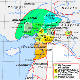
Carchemish, also spelled Karkemish, was an important ancient capital in the northern part of the region of Syria. At times during its history the city was independent, but it was also part of the Mitanni, Hittite and Neo-Assyrian Empires. Today it is on the frontier between Turkey and Syria.

The Tabqa Dam, or al-Thawra Dam as it is also named, most commonly known as Euphrates Dam, is an earthen dam on the Euphrates, located 40 kilometres (25 mi) upstream from the city of Raqqa in Raqqa Governorate, Syria. The city of Al-Thawrah is located immediately south of the dam. The dam is 60 metres (200 ft) high and 4.5 kilometres (2.8 mi) long and is the largest dam in Syria. Its construction led to the creation of Lake Assad, Syria's largest water reservoir. The dam was constructed between 1968 and 1973 with help from the Soviet Union. At the same time, an international effort was made to excavate and document as many archaeological remains as possible in the area of the future lake before they would be flooded by the rising water. When the flow of the Euphrates was reduced in 1974 to fill the lake behind the dam, a dispute broke out between Syria and Iraq that was settled by intervention from Saudi Arabia and the Soviet Union. The dam was originally built to generate hydroelectric power, as well as irrigate lands on both sides of the Euphrates. The dam has not reached its full potential in either of these objectives.

The Keban Dam is a hydroelectric dam on the Euphrates, located in the Elazığ Province of Turkey. The dam was the first and uppermost of several large-scale dams to be built on the Euphrates by Turkey. Although the Keban Dam was not originally constructed as a part of the Southeastern Anatolia Project (GAP), it is now a fully integrated component of the project, which aims to stimulate economic development in Southeastern Turkey. Construction of the dam commenced in 1966 and was completed in 1974. Keban Dam Lake, the reservoir created by Keban Dam, has a surface area of 675 square kilometres (261 sq mi) and is reputedly the fourth-largest lake in Turkey after Lake Van, Lake Tuz, and the reservoir created by the Atatürk Dam.

Emar is an archaeological site in Aleppo Governorate, northern Syria. It sits in the great bend of the mid-Euphrates, now on the shoreline of the man-made Lake Assad near the town of Maskanah. It has been the source of many cuneiform tablets, making it rank with Ugarit, Mari and Ebla among the most important archaeological sites of Syria. In these texts, dating from the 14th century BC to the fall of Emar in 1187 BC, and in excavations in several campaigns since the 1970s, Emar emerges as an important Bronze Age trade center, occupying a liminal position between the power centers of Upper Mesopotamia and Anatolia-Syria. Unlike other cities, the tablets preserved at Emar, most of them in Akkadian and of the thirteenth century BC, are not royal or official, but record private transactions, judicial records, dealings in real estate, marriages, last wills, formal adoptions. In the house of a priest, a library contained literary and lexical texts in the Mesopotamian tradition, and ritual texts for local cults.
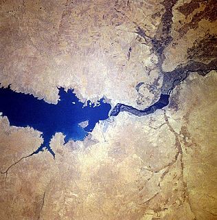
Lake Assad is a reservoir on the Euphrates in Raqqa Governorate, Syria. It was created in 1974 when the Tabqa Dam was closed. Lake Assad is Syria’s largest lake with a maximum capacity of 11.7 cubic kilometres (2.8 cu mi) and a maximum surface area of 610 square kilometres (240 sq mi). A vast network of canals uses water from Lake Assad to irrigate lands on both sides of the Euphrates. In addition, the lake provides drinking water for the city of Aleppo and supports a fishing industry. The shores of Lake Assad have developed into important ecological zones.
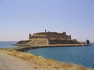
Qal'at Ja'bar is a castle on the left bank of Lake Assad in Raqqa Governorate, Syria. Its site, formerly a prominent hill-top overlooking the Euphrates Valley, is now an island in Lake Assad that can only be reached by an artificial causeway. Although the hilltop on which the castle sits was possibly already fortified in the 7th century, the current structures are primarily the work of Nur ad-Din, who rebuilt the castle from 1168 onwards. Since 1965, several excavations have been carried out in and around the castle, as well as restoration works of the walls and towers. The castle was a Turkish exclave between 1921 and 1973.

Halabiye is an archaeological site on the right bank of the Euphrates River in Deir ez-Zor Governorate, Syria. It was an ancient city and former bishopric known as Zenobia and a Latin Catholic titular see.

Zalabiye is an archaeological site on the left bank of the Euphrates in Deir ez-Zor Governorate, Syria.
Tell es-Sweyhat is the name of a large archaeological site on the Euphrates River in northern Syria. It is located in Raqqa Governorate roughly 95 km northeast of Aleppo and 60 km south of Carchemish. Also, an Uruk site of Jebel Aruda is located just across the river.

The Tishrin Dam is a dam on the Euphrates, located 90 kilometres (56 mi) east of Aleppo in Aleppo Governorate, Syria. The dam is 40 metres (130 ft) high and has 6 water turbines capable of producing 630 MW. Construction lasted between 1991 and 1999. Rescue excavations in the area that would be flooded by the dam's reservoir have provided important information on ancient settlement in the area from the Pre-Pottery Neolithic A (PPNA) period upward.

Habuba Kabira is the site of an Uruk settlement along the Euphrates in Syria, founded during the later part of the Uruk period. It was about 800 mi from the city of Uruk. The site is now mostly underwater due to the Tabqa Dam project.
Tell Fray is a tell, or settlement mound, on the east bank of the Euphrates in Raqqa Governorate, northern Syria. The archaeological site takes its name from an ancient irrigation canal, hence 'Fray' or 'Little Euphrates'. It was excavated in 1972 and 1973 as a joint Syrian–Italian operation under the direction of Adnan Bounni of the Syrian Service of Archaeological Excavations and Paolo Matthiae, the excavator of Ebla. The operation was part of the UNESCO-coordinated international effort to excavate as many sites as possible in the area that would be flooded by the reservoir of the Tabqa Dam, which was being constructed at that time. Tell Fray disappeared under the rising waters of Lake Assad in 1974. The excavations revealed occupation layers dating to the 14th century BCE, or Late Bronze Age. There were at least two temples in this city, one of them probably devoted to the god Teshub. A number of houses were also excavated. Two of these houses belonged to important officials. One of these was possibly a local representative or governor of the Hittite king, whereas the other was responsible for the maintenance of the canals in the area. The clay tablets found at Tell Fray indicate that the site belonged to the influence sphere of Ashtata, centred on Emar, which in turn fell under Carchemish, upstream from both Emar and Tell Fray. The site was destroyed by fire in the 13th century BCE, probably by the Middle Assyrian kings Shalmaneser I or Tukulti-Ninurta I, when the Assyrians conquered this area. Based on the cuneiform texts found in Tell Fray and elsewhere, it has been proposed that the name of the ancient site was either Yakharisha or Shaparu. Finds from the excavation are now on display in the National Museum of Aleppo.

Capitolias was an ancient city east of the Jordan River, and is identified with the modern village of Beit Ras in the Irbid Governorate in northern Jordan. Anciently it was a town of Coele-Syria.
Zaldapa was a large Late Roman fortified city in Scythia Minor/Moesia, located near today's Abrit, Bulgaria.
The Halabiye Dam is a proposed dam on the Euphrates in Deir ez-Zor Governorate, Syria. It will be the fourth and most southern dam on the Syrian Euphrates, after the Tishrin Dam, the Tabqa Dam and the Baath Dam. The proposed location for the dam is the narrow gap in the Euphrates valley northwest of Deir ez-Zor that is created by basalt outcrops on the left and right river banks. It is expected that dry areas will be brought under cultivation with irrigation water provided by the dam. In preparation of this project, the director of the Syrian Directorate-General of Antiquities and Museums (DGAM) appealed in 2009 to international teams of archaeologists to participate in the rescue excavations of the archaeological sites that would be threatened by the construction of the dam and the flooding of its reservoir. These excavations were expected to be carried out between 2010 and 2012. The sites that are threatened are located in the area that is projected to be flooded by the reservoir and in the area where construction works for the dam will take place. Important sites that are threatened include the Roman–Byzantine sites of Halabiye and Zalabiye that were first fortified by the Palmyrene queen Zenobia in the 3rd century CE. The lower town of Halabiye will be partially flooded by the reservoir and the Syrian government is cooperating with the United Nations Development Programme (UNDP) and UNESCO to limit the impact of the dam on this site as well as on Zalabiye. Other threatened sites include Bronze Age Tell Ma’dan and Tell Humeyda with Ubaid, Uruk and Byzantine material. Given the current instability in the region, it can be assumed that the project has been postponed.

Qasr al-Banat, Girls castle or Palace of the Ladies, are a set of brick ruins of a residence dating from 12th century in the Syrian city of Raqqa.
The Kelsey Museum of Archaeology is a museum of archaeology located on the University of Michigan central campus in Ann Arbor, Michigan, in the United States. The museum is a unit of the University of Michigan's College of Literature, Science, and the Arts. It has a collection of more than 100,000 ancient and medieval artifacts from the civilizations of the Mediterranean and the Near East. In addition to displaying its permanent and special exhibitions, the museum sponsors research and fieldwork and conducts educational programs for the public and for schoolchildren. The museum also houses the University of Michigan Interdepartmental Program in Classical Art and Archaeology.

Byzantine glass objects highly resembled their earlier Roman counterparts during the fourth and early fifth centuries CE in both form and function. Over the course of the fifth century CE, Byzantine glass blowers, based mostly in the area of Syria and Palestine, developed a distinct Byzantine style. While glass vessels continued to serve as the primary vehicles for pouring and drinking liquid, glassware for lighting, currency and commodity weights, window panes, and glass tesserae for mosaics and enamels also surged in popularity. Following the Arab conquests of the seventh century CE, large quantities of glass were imported from the Levant, which continued to produce raw and manufactured glass. Scholars once believed that glassware was an expensive luxury good reserved for the upper strata of society, however, recent archaeological excavations have unearthed a considerable quantity of unadorned glassware intended for lower-class residents.
