
Marina del Rey is an unincorporated seaside community in Los Angeles County, California, with an eponymous harbor that is a major boating and water recreation destination of the greater Los Angeles area. The port is North America's largest man-made small-craft harbor and is home to approximately 5,000 boats. The area is a popular tourism destination for both land and water activities such as paddle board and kayak rentals, dining cruises, and yacht charters. Land activities include bicycling on several bicycle paths, walking paths along the waterfront, and birdwatching (birding). Wildlife watching opportunities include California sea lions and harbor seals. Dolphins and whales occasionally visit the deeper waters of harbor. This Westside locale is approximately 4 miles (6.4 km) south of Santa Monica, 4 miles (6.4 km) north of Los Angeles International Airport, and 12.5 miles (20.1 km) west-southwest of Downtown Los Angeles.

Playa del Rey is a seaside community in the Santa Monica Bay and the Westside region of Los Angeles, California. It has a ZIP code of 90293 and area codes of 310 and 424. As of 2018, the community had a population of 16,230 people.

Westchester is a neighborhood in the City of Los Angeles and the Westside Region of Los Angeles County, California.
The Los Angeles Westside is an urban region in western Los Angeles County, California. It has no official definition, but sources like LA Weekly and the Mapping L.A. survey of the Los Angeles Times place the region on the western side of the Los Angeles Basin south of the Santa Monica Mountains.

Playa Vista is a neighborhood in the Westside area of Los Angeles, California. The area was the headquarters of Hughes Aircraft Company from 1941 to 1985 and the site of the construction of the Hughes H-4 Hercules "Spruce Goose" aircraft. The area began development in 2002 as a planned community with residential, commercial, and retail components. The community attracted businesses in technology, media and entertainment and, along with Santa Monica and Venice, Marina del Rey, Playa del Rey, Culver City, El Segundo and Mar Vista, has become known as Silicon Beach.

Del Rey is a neighborhood in the Westside of Los Angeles, surrounded on three sides by Culver City, California. Within it lie a police station, the largest public housing complex on the Westside, a public middle school and six public elementary schools. It is served by a neighborhood council and a residents association. Del Rey, with a 32,000+ population, has a large number of military veterans.
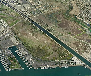
Ballona Wetlands Ecological Reserve is a protected area that once served as the natural estuary for neighboring Ballona Creek. The 577 acres (2.34 km2) site is located in Los Angeles County, California, just south of Marina del Rey. Ballona—the second-largest open space within the city limits of Los Angeles, behind Griffith Park—is owned by the state of California and managed by the California Department of Fish and Wildlife. The preserve is bisected generally east-west by the Ballona Creek channel and bordered by the 90 Marina freeway to the east.
Eric Owen Moss practices architecture with his eponymously named LA-based firm founded in 1973.

Westfield Culver City, is a shopping mall in Culver City, California, owned by the Westfield Group. Its anchor stores are JCPenney and Macy's. Junior anchors are Best Buy, Nordstrom Rack, Target, Forever 21, H&M, and Trader Joe's.

Rancho La Ballona was a 13,920-acre (56.3 km2) Mexican land grant in the present-day Westside region of Los Angeles County, Southern California.

Palisades del Rey was a 1921 neighborhood land development by Dickinson & Gillespie Co. that later came to be called the Playa del Rey district of Los Angeles County, California. It lay at an elevation of 135 feet. All of the houses in this area were custom built, many as beach homes owned by Hollywood actors and producers, including Cecil B. DeMille, Charles Bickford, and others.
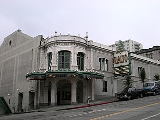
The Rialto Theatre in Tacoma, Washington was built in 1918 to showcase movies. Its design reflects the affluence following World War I. It reflects the character of a palace and is the result of efforts by entrepreneur Henry T. Moore and Tacoma architect Roland E. Borhek. Designed to hold 1500 patrons and retail space. The two-and-a-half-story structure is in the historic downtown of Tacoma. The area has long been associated with theaters and entertainment. The theater is freestanding, with a dramatic view on an incline with a classical façade sheathed of glazed white terra cotta. Both the interior and exterior retain most of the original design of Roland E. Borhek. The theater has an auditorium, proscenium with stage, a relocated projection booth, balcony, lobby, and commercial space. It has been altered with the removal of the storefronts and marquee. On the inside, the lobby's decorative ceiling has been hidden and the concession areas expanded.
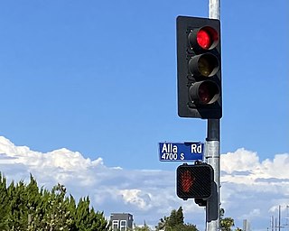
Alla is a former streetcar station and archaic place name located near Marina del Rey in the Westside region of Los Angeles County, California.
Cypress Grove, California was a stop on the Redondo Beach via Playa Del Rey Line of the Los Angeles streetcar system.
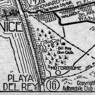
Motordrome is an archaic placename in Los Angeles County, California. It was a rail spur in the 1910s on the Redondo Beach via Del Rey Line, named for the Los Angeles Motordrome race track and airplane hangar.

The Sacramento Masonic Temple, built between 1913 and 1918, is a five-story building on J Street in downtown Sacramento, California. The building was listed on the National Register of Historic Places in 2001.
Silicon Beach is the Westside region of the Los Angeles metropolitan area that is home to more than 500 technology companies, including startups. It is particularly applied to the coastal strip from Los Angeles International Airport north to the Santa Monica Mountains, but the term may be applied loosely or colloquially to most anywhere in the Los Angeles Basin. Startups seeded here include Snapchat and Tinder. Major technology companies that opened offices in the region including Google, Yahoo!, YouTube, BuzzFeed, Facebook, Salesforce, AOL, Electronic Arts, Sony, EdgeCast Networks, MySpace, Amazon.com, Apple, Inc., and Netflix. By some 2012 metrics, the region was the second- or third-most prominent technology hub in the world. In the first six months of 2013, 94 new start-ups in Silicon Beach raised over $500 million in funding, and there were nine acquisitions.

Port Ballona is an archaic place name for an area near the center of Santa Monica Bay in coastal Los Angeles County, where Playa Del Rey and Del Rey Lagoon are located today. Port Ballona was a planned harbor and town site from circa 1859 to 1903. The name comes from the Rancho La Ballona Mexican land grant.

The Redondo Beach via Playa del Rey was an interurban railway route of the Pacific Electric. It operated between the Hill Street Terminal and Cliffton, south of Redondo Beach, through the company's Western Division.
Culver Boulevard is an east-west thoroughfare in the Westside region of Los Angeles County, California, connecting Venice Boulevard to the coast roads.
