Palisades del Rey, California

Last updated
Palisades del Rey
Surfridge
Former settlement
LAX2.jpg
Abandoned streets of Palisades del Rey, visible to the left of Los Angeles International Airport
USA California location map.svg
Red pog.svg
Palisades del Rey
Location in California
Coordinates: 33°56′25″N118°26′16″W / 33.94028°N 118.43778°W / 33.94028; -118.43778
Country United States
State California
County Los Angeles County
City Los Angeles
Elevation
[1]
135 ft (41 m)

Palisades del Rey (Spanish for "Palisades of the King") was a 1921 neighborhood land development by Dickinson & Gillespie Co. that later came to be called the Playa del Rey district of Los Angeles County, California. [1] It lay at an elevation of 135 feet (41 m). [1] All of the houses in this area were custom built, many as beach homes owned by Hollywood actors and producers, including Cecil B. DeMille, Charles Bickford, and others.

Contents

A southern portion of Playa del Rey became known as Surfridge. [2] [3] [4] It was south of the current remaining area of Playa del Rey and north of El Segundo and immediately west of the perimeter of Los Angeles International Airport (LAX). The area is bounded on the east by LAX, on the north by Waterview and Napoleon streets, on the south by Imperial Highway, and on the west by Vista del Mar. The beach to the west of the area is Dockweiler State Beach.

Development

Surfridge was developed in the 1920s and 1930s as "an isolated playground for the wealthy." [5] In 1925 the developer held a contest to name the neighborhood and awarded the $1,000 prize to an Angeleno who submitted "Surfridge." [5] The Los Angeles Times wrote that Surfridge was chosen "due to its brevity, euphony, ease of pronunciation ... but above all because it tells the story of this new wonder city." [5]

Salesmen pitched tents on the sand dunes and sold lots for $50 down and 36 monthly payments of $20. [5] House exteriors could only be made of stucco, brick or stone; frame structures were prohibited. [5] Development was slowed by the onset of the Great Depression, but in the early 1930s the wealthy began to buy lots to build large homes. [5]

Airport

Mines Field, a small airport at that time, opened to the east of Surfridge in 1928. It became a popular location for residents to see air shows. [5]

The growing number of commercial flights into Los Angeles following World War II meant a higher number of planes flying low over Surfridge. Many residents learned to co-exist with the noise from propeller planes, but jet engines were difficult to ignore. [5]

Aerial view of El Segundo and the area formerly known as Surfridge El Segundo, California aerial.jpg
Aerial view of El Segundo and the area formerly known as Surfridge

"If you lived in Surfridge prior to the late 1950s, you had to raise your voice a bit when having a conversation. After the jets came, you had to literally stop talking when they took off," said Duke Dukesherer, a business executive who has written about Surfridge's history. [5]

In the 1960s and 1970s, the area was condemned and acquired by the City of Los Angeles in a series of eminent domain purchases to facilitate airport expansion and to address concerns about noise from jet airplanes. Homeowners were forced to sell their property to the city. Several homeowners sued the city and remained in their houses for several years after the majority of houses were vacated. Eventually all the houses were either moved or demolished. [6]

Nature preserve

The neighborhood is now enclosed by chain-link fences. Old residential streets are still visible through the fencing and from the air. The area is now a protected habitat for the endangered El Segundo blue butterfly. In 2019, a number of rare burrowing owls were sighted nesting in the preserve. [7] California gnatcatchers are also found amidst the restored sand dunes and coastal sage scrub despite the noise. [8]

The only part of the neighbourhood still accessible to the public is Vista Del Mar Park, a small park with a playground and picnic area on Vista Del Mar Boulevard that is maintained by the City of Los Angeles. [9]

Related Research Articles

<span class="mw-page-title-main">South Bay (Los Angeles County)</span> Region of the Los Angeles metropolitan area in California, United States

The South Bay is a region of the Los Angeles metropolitan area, located in the southwest corner of Los Angeles County. The name stems from its geographic location stretching along the southern shore of Santa Monica Bay. The South Bay contains fourteen cities plus portions of the City of Los Angeles and unincorporated portions of the county. The area is bounded by the Pacific Ocean on the south and west and generally by the City of Los Angeles on the north and east.

<span class="mw-page-title-main">Playa del Rey, Los Angeles</span> Neighborhood of Los Angeles in California, United States

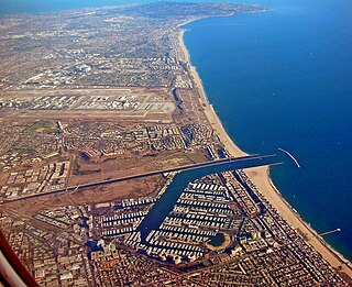
Playa del Rey is a seaside community in the Santa Monica Bay and the Westside region of Los Angeles, California. It has a ZIP code of 90293 and area codes of 310 and 424. As of 2018, the community had a population of 16,230 people.

<span class="mw-page-title-main">Westchester, Los Angeles</span> Neighborhood of Los Angeles in the United States

Westchester is a neighborhood in the City of Los Angeles and the Westside Region of Los Angeles County, California.

<span class="mw-page-title-main">El Segundo blue</span> Species of butterfly

The El Segundo blue is an endangered species of butterfly. It is endemic to a small dune ecosystem in Southern California that used to be a community called Palisades del Rey, close to the Los Angeles International Airport (LAX).

<span class="mw-page-title-main">Mar Vista, Los Angeles</span> Neighborhood of Los Angeles in California, United States of America

Mar Vista is a neighborhood on the Westside of Los Angeles, California. In 1927, Mar Vista became the 70th community to be annexed to Los Angeles. It was designated as an official city neighborhood in 2006.

<span class="mw-page-title-main">Area codes 310 and 424</span> Area codes in the Los Angeles metropolitan area

Area codes 310 and 424 are telephone area codes in the North American Numbering Plan (NANP) for the U.S. state of California. The numbering plan area includes the West Los Angeles and South Bay areas of Los Angeles County, a small portion of Ventura County, and Santa Catalina Island, which is located 26 miles (42 km) south.

<span class="mw-page-title-main">Playa Vista, Los Angeles</span> Neighborhood of Los Angeles in California, United States

Playa Vista is a neighborhood in the Westside area of Los Angeles, California, United States. The area was the headquarters of Hughes Aircraft Company from 1941 to 1985 and the site of the construction of the Hughes H-4 Hercules "Spruce Goose" aircraft. The area began development in 2002 as a planned community with residential, commercial, and retail components. The community attracted businesses in technology, media and entertainment and is part of Silicon Beach.

<span class="mw-page-title-main">Del Rey, Los Angeles</span> Neighborhood of Los Angeles in California, United States of America

Del Rey is a neighborhood in the Westside of Los Angeles, surrounded on three sides by Culver City, California. Within it lie a police station, the largest public housing complex on the Westside, a public middle school and six public elementary schools. It is served by a neighborhood council and a residents association. Del Rey, with a 32,000+ population, has a large number of military veterans.

<span class="mw-page-title-main">Dockweiler State Beach</span> State beach in Los Angeles County, California, United States

Dockweiler State Beach is a beach in Los Angeles, California, with 3.75 miles (6.04 km) of shoreline and a hang gliding practice and training area. Although a unit of the California state park system, it is managed by the Los Angeles County Department of Beaches and Harbors. Part of the park is located directly under the flight path of the adjacent Los Angeles International Airport (LAX). The 91-acre (37 ha) property was established in 1948. Originally part of Venice-Hyperion Beach State Park, it was renamed in honor of prominent early Angeleno Isidore B. Dockweiler in 1955.

<span class="mw-page-title-main">Ballona Wetlands</span> Estuary and marsh in California, United States

Ballona Wetlands Ecological Reserve is a protected area that once served as the natural estuary for neighboring Ballona Creek. The 577-acre (2.34 km2) site is located in Los Angeles County, California, just south of Marina del Rey. Ballona—the second-largest open space within the city limits of Los Angeles, behind Griffith Park—is owned by the state of California and managed by the California Department of Fish and Wildlife. The preserve is bisected generally east-west by the Ballona Creek channel and bordered by the 90 Marina freeway to the east.

<span class="mw-page-title-main">Marvin Braude Bike Trail</span> Bike path in Los Angeles County, California, United States

The Marvin Braude Bike Trail is a 22-mile (35 km) paved bicycle path that runs mostly along the shoreline of Santa Monica Bay in Los Angeles County, California. The coastal bike trail is widely acknowledged as Los Angeles’ “most popular bike path.”

The Imperial Highway is a west-east thoroughfare in the counties of Los Angeles, Orange, Riverside, San Diego, and Imperial in the U.S. state of California. The main portion of the existing route begins at Vista Del Mar in Los Angeles near the Los Angeles International Airport and ends at the Anaheim–Orange city line at Via Escola where it becomes Cannon Street. Historically, the Imperial Highway extended from Vista Del Mar to Calexico, where a portion of the highway still exists. The original route was replaced with other highways, leading the older portions of the Imperial Highway to fall out of use.

<span class="mw-page-title-main">California's 36th congressional district</span> U.S. House district for California

California's 36th congressional district is a U.S. congressional district in California. The 36th district is located primarily in the South Bay and Westside regions of Los Angeles. It takes in the cities of Beverly Hills, Santa Monica, the west side of Culver City, Hermosa Beach, Rancho Palos Verdes, Redondo Beach, Palos Verdes Estates, Rolling Hills Estates, El Segundo, Lomita, Manhattan Beach, and the west side of Torrance, as well as the Los Angeles neighborhoods of Venice, Playa del Rey, Palms, Cheviot Hills, Westwood Village, West Los Angeles, Mar Vista, Westchester, Marina Peninsula, and west side Harbor City.

<span class="mw-page-title-main">Los Angeles's 11th City Council district</span> American legislative district

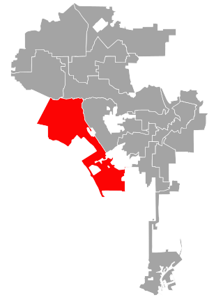
Los Angeles's 11th City Council district is one of the fifteen districts in the Los Angeles City Council. It is currently represented by Democrat Traci Park since 2022, who succeeded Mike Bonin after his retirement.

<span class="mw-page-title-main">Los Angeles's 6th City Council district</span> American legislative district

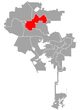
Los Angeles's 6th City Council district is one of the fifteen districts in the Los Angeles City Council. It is currently represented by Imelda Padilla.

The Wiseburn Unified School District is a school district in Los Angeles County, California operating elementary and middle schools, and hosting charter high schools. Its headquarters are on the grounds of the Da Vinci charter schools facility in El Segundo. Previously they were in Hawthorne.

<span class="mw-page-title-main">Port Ballona, California</span> 19th century planned harbor of Santa Monica Bay

Port Ballona is an archaic place name for an area near the center of Santa Monica Bay in coastal Los Angeles County, where Playa Del Rey and Del Rey Lagoon are located today. Port Ballona was a planned harbor and town site from circa 1859 to 1903. The name comes from the Rancho La Ballona Mexican land grant.

<span class="mw-page-title-main">History of Los Angeles International Airport</span>

Los Angeles International Airport is a major American airport in the United States that was constructed in 1928.

<span class="mw-page-title-main">Redondo Beach via Playa del Rey Line</span> Historic streetcar line in California

The Redondo Beach via Playa del Rey was an interurban railway route of the Pacific Electric. It operated between the Hill Street Terminal and Cliffton, south of Redondo Beach, through the company's Western Division.

References

  1. 1 2 3 U.S. Geological Survey Geographic Names Information System: Palisades del Rey, California
  2. "Ghostown del Rey" Archived 2010-02-12 at the Wayback Machine at Elsegundo.net
  3. Waffling article at JWAirFair.com
  4. Proposed Surfridge Memorial Archived 2009-04-26 at archive.today at TheGeister.com
  5. 1 2 3 4 5 6 7 8 9 Anton, Max. (2013, March 2). LAX ghost town a home to memories and rare butterflies. The Los Angeles Times.
  6. "Los Angeles Ghost Town: At the Hands of LAX" Archived 2013-04-29 at the Wayback Machine
  7. Sahagun, Louis (February 17, 2019). "This LAX-adjacent ghost town is now 'priceless coastal real estate' for rare owls". Los Angeles Times . Retrieved 18 February 2019.
  8. Lentz, Joan Easton (2019-12-12). "Opinion: Birds are vanishing from North America. There's a way to bring them back". Los Angeles Times . Retrieved 2019-12-16.
  9. "LA Parks: Vista Del Mar Park