Related Research Articles

Southern California is a geographic and cultural region that generally comprises the southern portion of the U.S. state of California. It includes the Los Angeles metropolitan area, the second most populous urban agglomeration in the United States. The region generally contains ten of California's 58 counties: Imperial, Kern, Los Angeles, Orange, Riverside, San Bernardino, San Diego, Santa Barbara, San Luis Obispo and Ventura counties.

Santa Ana is the second most populous city and the county seat of Orange County, California. Located in the Greater Los Angeles region of Southern California, the city's population was 310,227 at the 2020 census, making Santa Ana the 13th-most populous city in California and the 4th densest large city in the United States. Santa Ana is a major regional economic and cultural hub for the Orange Coast.

Los Angeles County, officially the County of Los Angeles, and sometimes abbreviated as L.A. County, is the most populous county in the United States and in the U.S. state of California, with 9,861,224 residents estimated as of 2022. It is the most populous non–state-level government entity in the United States. Its population is greater than that of 40 individual U.S. states. At 4,083 square miles (10,570 km2) and with 88 incorporated cities and many unincorporated areas, it is home to more than one-quarter of California residents and is one of the most ethnically diverse counties in the United States. Its county seat, Los Angeles, is also California's most populous city and the second-most populous city in the United States, with about 3.9 million residents. More recently, statewide droughts in California have further strained both the city’s and Los Angeles County’s water security.

The Tejon Pass, previously known as Portezuelo de Cortes, Portezuela de Castac, and Fort Tejon Pass is a mountain pass between the southwest end of the Tehachapi Mountains and northeastern San Emigdio Mountains, linking Southern California north to the Central Valley. Both the pass and the grade north of it to the Central Valley is commonly referred to as "the Grapevine". It has been traversed by major roads such as the El Camino Viejo, the Stockton – Los Angeles Road, the Ridge Route, U.S. Route 99, and now Interstate 5.
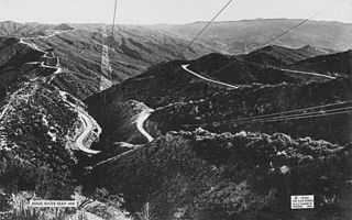
The Ridge Route, officially the Castaic–Tejon Route, was a two-lane highway between Los Angeles County and Kern County, California. Opened in 1915 and paved with concrete between 1917 and 1921, the road was the first paved highway directly linking the Los Angeles Basin with the San Joaquin Valley over the Tejon Pass and the rugged Sierra Pelona Mountains ridge south of Gorman. Much of the old road runs through the Angeles National Forest, and passes many historical landmarks, including the National Forest Inn, Reservoir Summit, Kelly's Half Way Inn, Tumble Inn, and Sandberg's Summit Hotel. North of the forest, the Ridge Route passed through Deadman's Curve before ending at Grapevine.

Neenach is an agricultural settlement in northwestern Los Angeles County, California, with a population of about 800. It is facing a massive change with the proposed construction of a 23,000-home planned community to its north called Centennial.
Gorman is an unincorporated community in northwestern Los Angeles County. It is located in Peace Valley south of the Tejon Pass, which links Southern California with the San Joaquin Valley and Northern California. Due to this location, the area has served as a historic travel stop dating back to the indigenous peoples of California. Tens of thousands of motorists travel through Gorman daily on the Golden State Freeway since the highway's completion in the mid-20th Century.
The 1857 Fort Tejon earthquake occurred at about 8:20 a.m. on January 9 in central and Southern California. One of the largest recorded earthquakes in the United States, with an estimated moment magnitude of 7.9, it ruptured the southern part of the San Andreas Fault for a length of about 225 miles, between Parkfield and Wrightwood.

Fort Tejon in California is a former United States Army outpost which was intermittently active from June 24, 1854, until September 11, 1864. It is located in the Grapevine Canyon between the San Emigdio Mountains and Tehachapi Mountains. It is in the area of Tejon Pass along Interstate 5 in Kern County, California, the main route through the mountain ranges separating the Central Valley from the Los Angeles Basin and Southern California. The fort's location protected the San Joaquin Valley from the south and west.

Elizabeth Lake is a natural sag pond that lies directly on the San Andreas Fault in the northern Sierra Pelona Mountains, in northwestern Los Angeles County, southern California. The lake has been dry since 2013 because of prolonged drought.

Ygnacio Ramón de Jesus del Valle was a Californio ranchero and politician. He owned much of the Santa Clarita Valley and served briefly as Mayor of Los Angeles and as a California State Assemblyman.

Interstate 5 (I-5) is a major north–south route of the Interstate Highway System in the United States, stretching from the Mexican border at the San Ysidro crossing to the Canadian border near Blaine, Washington. The segment of I-5 in California runs 796.77 miles (1,282.28 km) across the length of the state from San Ysidro to the Oregon state line south of the Medford-Ashland metropolitan area. It is the longest interstate in California, and accounts for more than half of I-5's total length.

The Old Santa Susana Stage Road, or Santa Susana Wagon Road, is a route taken by early travelers between the San Fernando Valley and Simi Valley near Chatsworth, California, via the Santa Susana Pass. The main route climbs through what is now the Santa Susana Pass State Historic Park, with a branch in Chatsworth Park South.
Los Angeles Township was a defunct township in Los Angeles County, California. It existed prior to the abolition of townships in California in the 1870s. Los Angeles Township consisted of areas surrounding the original city lands of Los Angeles, then a four-league square bordered by Hoover Street, Fountain Avenue, Indiana Street and Exposition Boulevard. These included the San Fernando Valley and present-day West Los Angeles and East Los Angeles. Most of this area has now been annexed to the city of Los Angeles, but a few portions exist as independent cities, including Glendale, Burbank and Santa Monica.
Rancho El Tejón was a 97,617-acre (395.04 km2) Mexican land grant in the Tehachapi Mountains and northeastern San Emigdio Mountains, in present-day Kern County, California. It was granted in 1843 by Governor Manuel Micheltorena to José Antonio Aguirre and Ygnacio del Valle.
The Stockton–Los Angeles Road, also known as the Millerton Road, Stockton–Mariposa Road, Stockton–Fort Miller Road or the Stockton–Visalia Road, was established about 1853 following the discovery of gold on the Kern River in Old Tulare County. This route between Stockton and Los Angeles followed by the Stockton–Los Angeles Road is described in "Itinerary XXI. From Fort Yuma to Benicia, California", in The Prairie Traveler: A Hand-book for Overland Expeditions by Randolph Barnes Marcy. The Itinerary was derived from the report of Lieutenant R. S. Williamson on his topographical survey party in 1853, that was in search of a railroad route through the interior of California.
Mud Spring, formerly called Aquaje Lodoso, is a spring and historic site in the western Antelope Valley, within northern Los Angeles County, southern California.
Centennial, California is a proposed 12,323-acre (49.87 km2) master-planned community on Tejon Ranch in northwestern Los Angeles County between Bakersfield and Los Angeles. It is situated in the far western Antelope Valley at the foothills of the Sierra Pelona and Tehachapi Mountains. It would be built along California State Route 138 east of Interstate 5 and northeast of Quail Lake.
San Jose Township was a defunct township in Los Angeles County, California. It existed prior to the abolition of townships in California, and appeared as a subdivision of Los Angeles County in the 1860, 1870 and 1880 U.S. Censuses. Its area encompassed Rancho San Jose, the eastern portions of the county drained by San Jose Creek, including what is now the cities of Pomona, Claremont and Walnut. In 1880, it was recorded as having 1170 residents - which made it one of the smallest townships in Los Angeles County, but nevertheless a sizable settlement in the region, larger than Bakersfield and slightly smaller than Riverside
Soledad Township was a defunct township in Los Angeles County, California. It existed prior to the abolition of townships in California. It was formed in 1866 when Tejon Township was divided between Los Angeles and the new Kern County. Soledad Township was the county's most extensive but least populated township. It stretched from the San Gabriel and Santa Susana Mountains to the Kern County line and was centered on Soledad Canyon. In 1870, the township had a population of 265.
References
- ↑ Paul R. Spitzzeri (Fall 2007). "What a Difference a Decade Makes: Ethnic and Racial Demographic Change in Los Angeles County during the 1860s" (PDF). Branding Iron.
- ↑ U.S. Census Bureau. "Population of the United States in 1860: California" (PDF).