Related Research Articles
The Los Angeles Community College District (LACCD) is the community college district serving Los Angeles, California, and some of its neighboring cities and certain unincorporated areas of Los Angeles County. Its headquarters are in Downtown Los Angeles. Over the past seventy-seven years, LACCD has served as educator to more than three million students. In addition to typical college aged students, the LACCD also serves adults of all ages: over half of all LACCD students are older than 25 years of age, and more than a quarter are 35 or older. LACCD educates almost three times as many Latino students and nearly four times as many African-American students as all of the University of California campuses combined. Eighty percent of LACCD students are from underserved populations. The Los Angeles Community College District is the largest community college district in the United States and is one of the largest in the world. The nine colleges within the district offer educational opportunities to students in Los Angeles. It serves students located in the Alhambra, Beverly Hills, Burbank, Culver City, Garvey, Las Virgenes, Los Angeles, Montebello, Palos Verdes and San Gabriel school districts. The district covers the Los Angeles city limits, San Fernando, Calabasas, Agoura Hills, Hidden Hills, Burbank, West Hollywood, Beverly Hills, Culver City, Alhambra, Monterey Park, San Gabriel, Rosemead, Montebello, Commerce, Vernon, Huntington Park, Bell, Cudahy, Bell Gardens, South Gate, Gardena, Carson, Lomita, Palos Verdes Estates, Rolling Hills, Rancho Palos Verdes, and numerous unincorporated communities, including East Los Angeles, Florence-Firestone, Athens, and Walnut Park. The LACCD consists of nine colleges and covers an area of more than 882 square miles (2,280 km2).

Southern California is a geographic and cultural region that generally comprises the southern portion of the U.S. state of California. It includes the Los Angeles metropolitan area as well as the Inland Empire. The region generally contains ten of California's 58 counties: Imperial, Kern, Los Angeles, Orange, Riverside, San Bernardino, San Diego, Santa Barbara, San Luis Obispo and Ventura counties.

Weedpatch is an unincorporated community and census-designated place (CDP) in Kern County, California, United States. Weedpatch is 10 miles (16 km) south-southeast of Bakersfield. It is considered to be one of the poorest areas in Kern County. As of the 2010 census it had a population of 2,658.
The Los Angeles Westside is an urban region in western Los Angeles County, California, United States. It has no official definition, but sources like LA Weekly and the Mapping L.A. survey of the Los Angeles Times place the region on the western side of the Los Angeles Basin south of the Santa Monica Mountains.

Vasquez Rocks Natural Area Park is a 932-acre (377-hectare) park located in the Sierra Pelona in northern Los Angeles County, California. It is known for its rock formations, the result of sedimentary layering and later seismic uplift. It is located near the town of Agua Dulce, between the cities of Santa Clarita and Palmdale. The area is visible from the Antelope Valley Freeway. Its location approximately 25 miles (40 km) from downtown Los Angeles places it within Hollywood's "studio zone" and makes it a popular filming location for films and television programs.

The Cahuenga Pass, also known by its Spanish name Paseo de Cahuenga, is a low mountain pass through the eastern end of the Santa Monica Mountains in the Hollywood Hills district of the City of Los Angeles, California. It has an elevation of 745 ft (227 m). The Cahuenga Pass connects the Los Angeles Basin to the San Fernando Valley via U.S. Route 101 and Cahuenga Boulevard. It is the lowest pass through the mountains.

Fort Tejon in California is a former United States Army outpost which was intermittently active from June 24, 1854, until September 11, 1864. It is located in the Grapevine Canyon between the San Emigdio Mountains and Tehachapi Mountains. It is in the area of Tejon Pass along Interstate 5 in Kern County, California, the main route through the mountain ranges separating the Central Valley from the Los Angeles Basin and Southern California. The fort's location protected the San Joaquin Valley from the south and west.
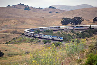
The Coast Line is a railroad line between Burbank, California and the San Francisco Bay Area, roughly along the Pacific Coast. It is the shortest rail route between Los Angeles and the Bay Area. Though not as busy as the Surf Line, the continuation of the Coast Line southbound to San Diego, it still sees freight movements and lots of passenger trains. The Pacific Surfliner, which runs from the San Diego Santa Fe Depot to San Luis Obispo via Union Station in Los Angeles, is the third busiest Amtrak route, and the busiest outside of the Northeast Corridor between Washington D.C. and Boston.

California's 29th congressional district is a congressional district in the U.S. state of California based in the north central San Fernando Valley. The district is represented by Democrat Tony Cárdenas.
California's 30th congressional district is a congressional district in the U.S. state of California. The 30th district takes in all of Burbank and Glendale, the Linda Vista neighborhood of Pasadena, and the Los Angeles communities of Tujunga, Hollywood, West Hollywood, Edendale, Park La Brea, Hancock Park, and westside Echo Park. The district is currently represented by Democrat Adam Schiff.

Santa Clarita station is a Metrolink train station in the city of Santa Clarita, California. It is served by Metrolink's Antelope Valley Line between Los Angeles Union Station and Lancaster station. Because the City of Santa Clarita has three other Metrolink stations, this station is sometimes referred to as Soledad Metrolink. City of Santa Clarita Transit offers connecting bus service at the station.
Wilmar was the former name of a then-unincorporated district of San Gabriel Township in the San Gabriel Valley, about eight miles east of the center of Los Angeles. In the 1940 census, Wilmar had a population of 11,590. Wilmar was combined with the unincorporated communities of Garvey and Potrero Heights to become the unincorporated community of South San Gabriel in the early 1950s. It was named for the city of Wilmar, Arkansas by "Arkies" who migrated to the area as a rural counterpart to their roots in Arkansas.
Radio Nueva Vida is a Spanish-language Christian radio network based in Camarillo, California, United States. It is owned and operated by The Association for Community Education, Inc., a California non-profit 501(c)(3) organization established in 1981.
Los Angeles Township was a defunct township in Los Angeles County, California. It existed prior to the abolition of townships in California in the 1870s. Los Angeles Township consisted of areas surrounding the original city lands of Los Angeles, then a four-league square bordered by Hoover Street, Fountain Avenue, Indiana Street and Exposition Boulevard. These included the San Fernando Valley and present-day West Los Angeles and East Los Angeles. Most of this area has now been annexed to the city of Los Angeles, but a few portions exist as independent cities, including Glendale, Burbank and Santa Monica.
Rancho La Liebre was a 48,800-acre (197 km2) Mexican land grant in present-day Kern County, California and Los Angeles County, given in 1846 by Governor Pío Pico to José María Flores. Liebre means "Hare" in Spanish and the rancho was named as such because of the abundance of jack rabbits in the area.

Peace Valley is a valley in the northwestern corner of Los Angeles County, California, running northeast−southeast along the San Andreas Fault and a section of Interstate 5 near Tejon Pass. The unincorporated community of Gorman is located within the valley.

Phonehenge West was a large folk art structure envisioned and constructed by Alan Kimble "Kim" Fahey, which included a 70-foot tower made from reclaimed material such as telephone poles, and props from old movie sets. The structure rested on his 1.7 acre property in Acton, California. The compound included 13 structures and was a representation of folk art.
Stickneys Ferry was a settlement established in what became Tulare County. The ferry proper was where the Stockton - Los Angeles Stagecoach Road crossed the White River. The settlement was on Telegraph Flat, just below the confluence of the White River and Tyler Gulch, about 4.66 miles west of Tailholt.
San Jose Township was a township in Los Angeles County, California. It existed prior to the abolition of townships in California, and appeared as a subdivision of Los Angeles County in the 1860, 1870 and 1880 U.S. Censuses. Its area encompassed Rancho San Jose, the eastern portions of the county drained by San Jose Creek, including what is now the cities of Pomona, Claremont and Walnut. In 1880, it was recorded as having 1170 residents - which made it one of the smallest townships in Los Angeles County, but nevertheless a sizable settlement in the region, larger than Bakersfield and slightly smaller than Riverside
Tejon Township was a defunct township in Los Angeles County, California. It existed prior to the abolition of townships in California in the 1870s. By far the largest of the county's townships, it encompassed an area from the San Gabriel and Santa Susana Mountains in the south to the Tulare County line in the north. It was centered on Fort Tejon. In 1860, the township had a population of 920.
References
- ↑ Paul R. Spitzzeri (Fall 2007). "What a Difference a Decade Makes: Ethnic and Racial Demographic Change in Los Angeles County during the 1860s" (PDF). Branding Iron.
- ↑ U.S. Census Bureau. "Population of the United States in 1860: California" (PDF).