
Dryden is the second-largest city in the Kenora District of Northwestern Ontario, Canada, located on Wabigoon Lake. It is the least populous community in Ontario incorporated as a city. The City of Dryden had a population of 7,749 and its population centre had a population of 5,586 in 2016.

Fort William was a city in Ontario, Canada, located on the Kaministiquia River, at its entrance to Lake Superior. It amalgamated with Port Arthur and the townships of Neebing and McIntyre to form the city of Thunder Bay in January 1970. Since then, it has been the largest city in Northwestern Ontario. The city's Latin motto was A posse ad esse, featured on its coat of arms designed in 1900 by town officials, "On one side of the shield stands an Indian dressed in the paint and feathers of the early days; on the other side is a French voyageur; the cent[re] contains a grain elevator, a steamship and a locomotive, while the beaver surmounts the whole."

Nickel Centre was a town in Ontario, Canada, which existed from 1973 to 2000.

West Nipissing is a municipality in Northeastern Ontario, Canada, on Lake Nipissing in the Nipissing District. It was formed on January 1, 1999, with the amalgamation of seventeen and a half former towns, villages, townships and unorganized communities.

The English River is a river in Kenora District and Thunder Bay District in Northwestern Ontario, Canada. It flows through Lac Seul to join the Winnipeg River at Tetu Lake as a right tributary. The river is in the Hudson Bay drainage basin, is 615 kilometres (382 mi) long and has a drainage basin of 52,300 square kilometres (20,200 sq mi). Although there are several hydroelectric plants on this river, the English River upstream of Minnitaki Lake is notable as one of the few large river systems in northwestern Ontario with a natural flow and without any upstream source of pollution. It is the fourth longest river entirely in Ontario.

The Wabigoon River is a river in Kenora District in northwestern Ontario, Canada. It flows from Raleigh Lake past Dryden, Ontario on Wabigoon Lake to join the English River. The name "Wabigoon" comes from the Ojibwe waabigon, "marigold", or waabi-miigwan, "white feather".

Biscotasing, often referred to as simply Bisco, is a community in the Unorganized North Part of Sudbury District in Northeastern Ontario, Canada. It was founded on the shores of Lake Biscotasi on the Spanish River in 1884 by Canadian Pacific Railway as a railway construction town, and the first divisional point west of Sudbury. The rails of westward track laying gangs reached this area in October 1884.
Asubpeeschoseewagong First Nation is an Ojibwe First Nations band government who inhabit northern Kenora in Ontario, Canada. Their landbase is the 4,145 ha English River 21 Indian Reserve. It has a registered population of 1,595 as of October 2019, of which the on-reserve population was 971. As of October 2023, the community had a registered population of 1,608. They are a signatory to Treaty 3.
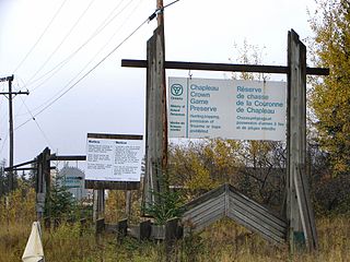
The Chapleau Crown Game Preserve is a fur bearing animal preserve area in Ontario, Canada, north-east of Lake Superior. It covers some 7,000 square kilometres (2,700 sq mi) in the Algoma and Sudbury Districts, and is officially classified as a Crown Game Preserve by the Government of Ontario Ministry of Natural Resources.

Batchawana Bay is a small bay in Algoma District in Northeastern Ontario, Canada. It is on the eastern shore of Lake Superior, approximately 50 kilometres (31 mi) north of Sault Ste. Marie.
The Berens River is a river in the provinces of Manitoba and Ontario, Canada. It flows west from an unnamed lake in Kenora District, Ontario, and discharges its waters into Lake Winnipeg near the community and First Nation of Berens River, Manitoba. The river has a number of lakes along its course, and many rapids.

Ear Falls is a township located in Northwestern Ontario, Canada, on the banks of the English River, Lac Seul, Pakwash Lake and Wenesaga Lake. It is located along Highway 105, 100 kilometres (62 mi) north of Highway 17 and Vermilion Bay, about halfway between Highway 17 and Red Lake, or about 480 kilometres (300 mi) northwest of Thunder Bay.
Savant Lake is an unincorporated place and community in Unorganized Thunder Bay District in northwestern Ontario, Canada.
King's Highway 72, commonly referred to as Highway 72, is a provincially maintained highway in the northern half of the Canadian province of Ontario. The highway connects Highway 17 in Dinorwic with the town of Sioux Lookout, where there are connections with Highway 516 towards Savant Lake and Highway 642 towards Silver Dollar.

Vermilion Bay is an unincorporated community on Vermilion Bay on Eagle Lake in the township of Machin, Kenora District in northwestern Ontario, Canada. It is located on Ontario Highway 17 between the cities of Kenora to the west and Dryden to the east.

Hudson is an unincorporated place and community in the municipality of Sioux Lookout, Kenora District in northwestern Ontario, Canada. It is located on Lost Lake on the English River in the Nelson River drainage basin.

Eagle Lake is a lake in Kenora District, Ontario, Canada, west of the City of Dryden. The communities of Vermilion Bay and Eagle Lake First Nation are located on the lake's north shore.
The Canyon River is a river in the Hudson Bay drainage basin in Unorganized Kenora District in northwestern Ontario, Canada. it is a tributary of the Wabigoon River.

La Cloche Provincial Park is a provincial park at the boundary of Algoma and Sudbury Districts in Ontario, Canada. The park consists of an unspoiled section of the La Cloche Mountains that stretch along the North Channel of Georgian Bay, as well as several islands in the channel.
