
Kukuihaele is a census-designated place (CDP) in Hawaiʻi County, Hawaiʻi, United States. The population was 281 at the 2020 census.

Carradale is a village on the east side of the Kintyre Peninsula, overlooking the Kilbrannan Sound and the west coast of the Isle of Arran in the Firth of Clyde, approximately 16 miles from Campbeltown. To the north of Carradale is the coastal peak known as Torr Mor; nearby are the hamlet of Dippen and Dippen Bay. Population: 577 ~ 2024
Torrisdale is a small village on the eastern coast of the Kintyre Peninsula of Scotland. The village is along Torrisdale Bay, an inlet of the Kilbrannan Sound. It is the location of Torrisdale Castle, a 19th-century castle that is now a tourist destination.
Cammo is a northwestern suburb of Edinburgh, the capital of Scotland. It is south of A90, at the edge of the city, approximately 6 miles from the city centre.
Salybia or Salibia is a village on the east coast of Dominica in Saint David Parish. It is located to the south of Pagua Bay and north of the town of Castle Bruce. It is the main commercial and administrative centre for the Kalinago Territory, the only Indigenous people's reserve in the Caribbean.

Quholm is a farm in the northeast of Shapinsay, in the islands of Orkney, Scotland.
Sandsting is a parish in the West Mainland of Shetland, Scotland, forming a southern arm of the Walls Peninsula. After the parish of Aithsting was annexed into Sandsting in the sixteenth century, it became known as Sandsting and Aithsting parish.
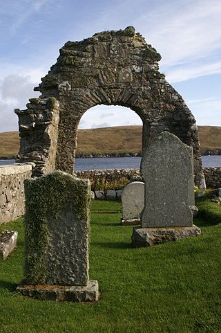
Dippen is a settlement on the Isle of Arran in the Firth of Clyde, Scotland, where there is an interesting chambered cairn.

Coldingham Bay is an inlet in the North Sea coast, just over three kilometres north of the town of Eyemouth in the Scottish Borders area of Scotland. It is situated at grid reference NT918666 and is easily reached by a minor road which leaves the B6438 road at Coldingham.

Carmel Bay State Marine Conservation Area (SMCA) is a marine protected area in Carmel Bay. Carmel Bay is adjacent to the city of Carmel-by-the-Sea and is near Monterey, on California’s central coast. The marine protected area covers 2.12 square miles. Recreational fishing of finfish and limited commercial taking of kelp is permitted within the SMCA.

Largo Bay is a bay on the northern shore of the Firth of Forth, on the coast of Fife, Scotland.
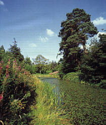
Kildonald Bay is a bay on the eastern side of the Kintyre Peninsula of Scotland. Kildonald Bay is an element of Kilbrannan Sound that separates the Kintyre Peninsula from the Isle of Arran. Other bays along the east side of the Kintyre Peninsula include Dippen Bay.

Dippen is a hamlet on the east coast of the Kintyre Peninsula in Scotland. The community of Dippen is in close proximity to Dippen Bay. Roads on the east coast of Kintyre were greatly improved in the era circa 1776, when the settlement was known as Duppin.

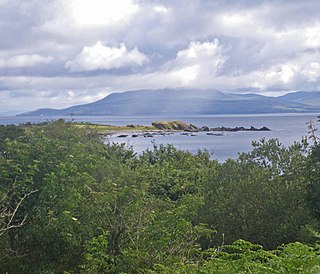
Torrisdale Bay is a coastal embayment along the east side of the Kintyre Peninsula within Kilbrannan Sound in Scotland. The shoreline of the bay consists partially of a shingle beach. Nearby is located Torrisdale Castle. The villages of Torrisdale and Bridgend lie along Torrisdale Bay with Carradale directly to the north. Bottlenose dolphins and harbor porpoises are often sighted.
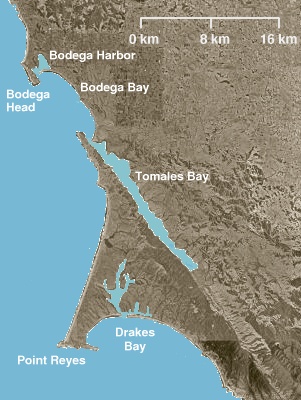
Point Reyes State Marine Reserve (SMR) and Point Reyes State Marine Conservation Area (SMCA) are two adjoining marine protected areas that extend offshore of Point Reyes Headlands and within Drakes Bay in Marin County on California's north central coast. The combined area of these marine protected areas is 21.49 square miles (55.7 km2), with 9.38 in the SMR, and 12.11 in the adjacent SMCA. Point Reyes SMR prohibits the take of all living marine resources. Point Reyes SMCA prohibits the take of all living marine resources, except the recreational and commercial take of Dungeness crab by pot and salmon by trolling.

The borders of the oceans are the limits of Earth's oceanic waters. The definition and number of oceans can vary depending on the adopted criteria. The principal divisions of the five oceans are the Pacific Ocean, Atlantic Ocean, Indian Ocean, Southern (Antarctic) Ocean, and Arctic Ocean. Smaller regions of the oceans are called seas, gulfs, bays, straits, and other terms. Geologically, an ocean is an area of oceanic crust covered by water.

Gruinard Bay is a large remote coastal embayment, located 12 miles north of Poolewe, in northwestern Ross and Cromarty, and is in the former parish of Lochbroom, in the west coast of Scotland.
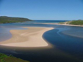
Kyle of Durness is a coastal inlet on the north coast of Scotland in the county of Sutherland. It extends 5+1⁄2 miles inland from Balnakeil and divides the Cape Wrath peninsula from the mainland. The nearest village is Durness.
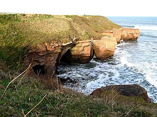
The Berwickshire Coastal Path is a walking route some 48 kilometres (30 mi) long. It follows the eastern coastline of Scotland from Cockburnspath in the Scottish Borders to Berwick upon Tweed, just over the border in England. At Cockburnspath the path links with the Southern Upland Way and the John Muir Way.
