
Chikmagalur, officially Chikkamagaluru is an administrative district in the Malnad subregion of Karnataka, India. Coffee was first cultivated in India in Chikmagalur. The hills of Chikmagalur are parts of the Western Ghats and the source of Tunga and Bhadra rivers. Mullayanagiri, the highest peak in Karnataka is located in the district. The area is well known for the Sringeri Mutt that houses the Dakshina Peeta established by Adi Shankaracharya.
Bhatpara is a city and a municipality of North 24 Parganas district in the Indian state of West Bengal. It is a part of the area covered by Kolkata Metropolitan Development Authority (KMDA).

Jind district is one of the 22 districts of Haryana state in northern India. Jind town is the administrative headquarters of the district. It is part of Hisar Division and was created in 1966.

Khargone district, formerly known as West Nimar district, is a district of Madhya Pradesh state in central India. The district lies in the Nimar region and is part of the Indore Division. The district headquarters is the city of Khargone, which lies south of the Indore metropolis, the headquarters of Indore district.

Sangrur is a city in Sangrur district of the Indian state of Punjab, India. It is the headquarters of Sangrur District.

Bhawanigarh, earlier known as Dhode, is a town and a municipal council (Class-2) in the Sangrur district in the state of Punjab, India. It is also the headquarters of Bhawanigarh tehsil, which was formed in December 2016. The town is also called Dhode, after the clan of its original founders. The town lies 19 kilometres east of Sangrur on the Patiala-Sangrur road whereas Patiala is 39 kilometres east of Bhawanigarh. The literacy rate is higher than other places of Sangrur. Bhawanigarh is divided into 15 wards. The Bhawanigarh block consists of 66 villages in the Sangrur district.
Bikramganj is a nagar parishad city and corresponding community development block of Rohtas district, Bihar, India. At the time of the 2011 census, the city of Bikramganj had a population of 48,465, in 7,968 households, while the overall subdistrict had a population of 163,565. The main commodities produced in Bikramganj are rice and pulses. The city of Bikramganj has a slum called Dhangai which, in 2011 had a population of 3,955 in 637 households. Bikramganj is located at 25.2°N 84.25°E. It has an average elevation of 77 metres (252 feet).
Lehragaga is a town and a municipal council in Sangrur district in the Indian state of Punjab. It is near the border of Punjab and Haryana. Haryana is about 15 km from Lehragaga. Asia's largest CBG plant named Verbio India, is in Lehragaga. It has a railway station. In lehragaga there are many schools, colleges and financial institutes.
Sunam Udham Singh Wala is a town and a tehsil, near city of Sangrur in Sangrur district in the Indian state of Punjab. The city of Sunam Udham Singh Wala, which falls in Sunam Udham Singh Wala tehsil, was previously known only as Sunam. The Government of Punjab renamed it after the Indian freedom fighter and martyr Udham Singh in 2006.
Giddaluru is a town in the Prakasam district of the Indian state of Andhra Pradesh. It is the mandal headquarters of the Giddaluru mandal in Markapur revenue division. It was part of kurnool district till 1969 later it was merged into Prakasam district in 1970. Till 2008 it was under Nandyal parliament segment after delimitation it was moved to Ongole MP segment. Giddalur is also known as "3 zilla la muddu bidda " because during the Britishers rule it was in kadapa district later moved to kurnool then in 1970 merged in prakasam district. Giddalur is the only constituency in coastal districts which has Rayalseema culture,slang and traditions. Giddalur town has good transport connectivity to Nandyal, Markapur, Podili, Ongole, Kurnool, Kadapa.
Sangrur district is in the state of Punjab in northern India. Sangrur city is the district headquarters. It is one of the five districts in Patiala Division in the Indian state of Punjab. Neighbouring districts are Malerkotla (north), Barnala (west), Patiala (east), Mansa (southwest) and Fatehabad (Haryana) and Jind (Haryana) (south).

Aralam Wildlife Sanctuary is the northernmost wildlife sanctuary of Kerala, southwest India. It is 55 km2 (21 sq mi) in area and located on the western slope of the Western Ghats. It was established in 1984 with its headquarters near Iritty. Aralam Wildlife Sanctuary is situated in the southeast part of Kannur District. It lies between 11° 54′ and 11° 59′ north latitude and 75° 47′ and 75° 57′ east longitude.
Naya Sanwara is a village in the Sirohi district of Rajasthan, India. On the southeastern border of the village, there is a large lake where the Ambamata Temple is located. The village is administered by a locally elected president, known as Pradhan or Sarpanch. This village depends on its sub-district (Tehsil) Pindwara, the nearest city, for all major economic activities.==={Activities}===
Kakuwala is a small village in Sunam block of Sangrur District in Punjab, India, which is situated on Sangrur-Patran National Highway - 71, about 30 km from Sangrur and 115 km from state capital of Chandigarh. Geographically, to its north lie Dirba and Khetla, to south-west lie the village of Ladbanjara Kalan while to its south-east are Patran and Dugal. It is named after its founder landlord, Kaku Singh. Its population is about 1,000 with a total of 153 households.
Balran is a village of Sub division Moonak in Sangrur district in the state of Punjab, India. It is 54 km to the south of district headquarters Sangrur and 157 km from state capital Chandigarh. This village is near the border of the Sangrur district and Fatehabad district in state of Haryana.
Changaliwala is a village in Sub division Lehragaga in Sangrur district in the state of Punjab. It is located 40 km to the south of District headquarters Sangrur, 149 km from State capital Chandigarh. Earlier the village was called Kartarpura, named after Numberdar Kartar Singh. But as many people migrated here from Changal Village in District Sangrur, it was renamed Changaliwala.

Dirba Assembly constituency is a Punjab Legislative Assembly constituency in Sangrur district, Punjab state, India.
Sangrur Assembly constituency is a Punjab Legislative Assembly constituency in Sangrur district, Punjab state, India. Constituency consists of Sangrur, Bhawanigarh and other nearby villages. Current MLA from constituency is Narinder Kaur Bharaj of the Aam Aadmi Party.

Nathumajra is a village in the Malerkotla district of Punjab, India. Formerly a part of the Sangrur district, it is located in the Ahmedgarh tehsil. It is situated 15 kilometres (9.3 mi) away from district headquarter Malerkotla. As per 2016 stats, Nathu Majra village is also a gram panchayat.
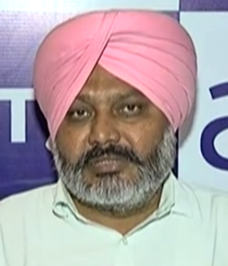
Harpal Singh Cheema is an Aam Aadmi Party MLA from Dirba Assembly constituency located in Sangrur District, Punjab. In March 2022, he became first dalit to be a finance minister of Punjab. He joined the Aam Aadmi Party just before the 2017 Punjab Legislative Assembly election. He contested and won the election from Dirba Assembly constituency against a popular Punjabi Kabbadi player Gulzar Singh Moonak from Shiromani Akali Dal and Ajaib Singh Ratolan from Indian National Congress. In July 2018 he was appointed leader of opposition of Punjab Legislative Assembly.

