
Audlem is a large village and civil parish located in the unitary authority of Cheshire East and the ceremonial county of Cheshire in North West England, approximately 7 mi (11 km) south of Nantwich. Close to the border with the neighbouring county of Shropshire, the village is eight miles (13 km) east of Whitchurch and seven miles (11 km) north of Market Drayton. According to the 2001 census, the population of the entire civil parish was 1,790, increasing to 1,991 at the 2011 Census.

Disley is a village and civil parish in Cheshire, England, on the edge of the Peak District in the Goyt valley south of Stockport, close to the county boundary with Derbyshire at New Mills. The population at the 2011 Census was 4,294. To the north, the River Goyt and the Peak Forest Canal, which opened in 1800, pass along the edge of the village. Today it is a dormitory village retaining a semi-rural character.

Macclesfield was, from 1974 to 2009, a local government district with borough status in Cheshire, England. It included the towns of Bollington, Knutsford, Macclesfield and Wilmslow and within its wider area the villages and hamlets of Adlington, Disley, Gawsworth, Kerridge, Pott Shrigley, Poynton, Prestbury, Rainow, Styal, Sutton and Tytherington.

Whaley Bridge is a town and civil parish in the High Peak district of Derbyshire, England, on the River Goyt, 16 miles (26 km) southeast of Manchester, 7 miles (11 km) north of Buxton, 9 miles (14 km) east of Macclesfield and 28 miles (45 km) west of Sheffield. It had a population of 6,455 at the 2011 census, including Furness Vale, Horwich End, Bridgemont, Fernilee, Stoneheads and Taxal.
Dore or Doré may refer to:

High Lane is a village in the Metropolitan Borough of Stockport, Greater Manchester, England, although it was historically in Cheshire. It is on the Macclesfield Canal, 5 miles (8 km) from Stockport.
A wolverine is a stocky and muscular carnivorous mammal that resembles a small bear.

Macclesfield is a constituency currently represented in the House of Commons of the UK Parliament since 2010 by David Rutley, a Conservative.
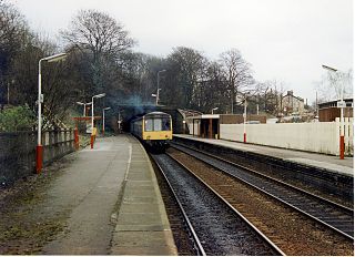
Disley railway station serves the village of Disley in Cheshire, England. It is 12+1⁄3 miles (19.8 km) south east of Manchester Piccadilly on the Manchester to Buxton line, built by the Stockport, Disley and Whaley Bridge Railway. The station, and all trains serving it, are operated by Northern Trains.

Rainow is a village and civil parish in Cheshire, England, in the valley of the River Dean and next to the B5470 road between Macclesfield and Kettleshulme. It straddles the eastern side of the Peak District border of Derbyshire and Cheshire, and is surrounded by pasture farmland. The Peak District Boundary Walk runs past the village. The village's name comes from the Old English Hraefn Hoe, meaning Ravens' Hill. It is a former coal-mining village and has a population of around 2,500.
Prestbury is a village and civil parish in Cheshire, England, about 1.5 miles (3 km) north of Macclesfield. At the 2001 census, it had a population of 3,324; it increased slightly to 3,471 at the 2011 census. Alongside fellow Cheshire Golden Triangle villages, Wilmslow and Alderley Edge, it is one of the more sought-after places in the north. The ecclesiastical parish is almost the same as the former Prestbury local government ward which consisted of the civil parishes of Prestbury, Adlington and Mottram St Andrew.

Kettleshulme is a village and civil parish in Cheshire, England. The village is close to the border with Derbyshire, on the B5470 road from Whaley Bridge to Macclesfield in the valley of the Todd Brook, a tributary of the River Goyt. In 2001 it had a population of 353.

Cheshire East is a unitary authority area with borough status in the ceremonial county of Cheshire, England. The local authority is Cheshire East Council. The main towns within the area are Crewe, Macclesfield, Congleton, Sandbach and Nantwich. The council is based in Sandbach.

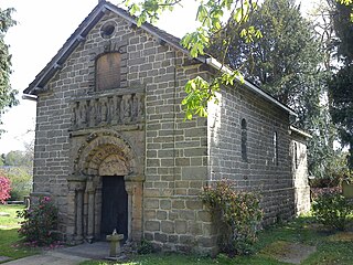
St Mary's Church is an Anglican parish church in the diocese of Chester, the archdeaconry of Macclesfield and the deanery of Chadkirk. It is on a hill overlooking the village of Disley, Cheshire, England. It is recorded in the National Heritage List for England as a designated Grade II* listed building. Its benefice is combined with that of St John, Furness Vale.

Disley is a village in the Canadian province of Saskatchewan within the Rural Municipality of Lumsden No. 189 and Census Division No. 6. It is located 18 km (11 mi) west of Lumsden just south of the Louis Riel Trail and 48 kilometres northwest of the City of Regina.
Chipperfield is a village and civil parish in England.