Disley

Last updated

Disley
Disley in 2005.jpg
Disley village centre
Cheshire UK location map.svg
Red pog.svg
Disley
Location within Cheshire
Population4,294 (2011)
OS grid reference SJ972845
  London 186 miles (299 km)
Civil parish
  • Disley
Unitary authority
Ceremonial county
Region
Country England
Sovereign state United Kingdom
Post town STOCKPORT
Postcode district SK12
Dialling code 01663
Police Cheshire
Fire Cheshire
Ambulance North West
UK Parliament
List of places
UK
England
Cheshire
53°21′25″N2°02′35″W / 53.357°N 2.043°W / 53.357; -2.043

Disley is a village and civil parish in Cheshire, England. [1] [2] It is located on the edge of the Peak District in the Goyt valley, south of Stockport and close to the county boundary with Derbyshire at New Mills. The population at the 2011 Census was 4,294. [3] To the north, the River Goyt and the Peak Forest Canal, which opened in 1800, pass along the edge of the village. Today, it is a dormitory village retaining a semi-rural character.

Contents

The parish includes part of the neighbouring village of Newtown, the bulk of which is in Derbyshire. [4]

History

Its Anglo-Saxon name was Dystiglegh, meaning "wood or clearing by a mound" or possibly "windy settlement". [5] In the 13th century, in the time of Edward I, there are references to confirmatory grants of land made to Jordan de Dystelegh of Disley Hall and Roger de Stanley-de-Dystelegh of Stanley Hall in the district, pointing to even older local settlements. It later had the name Dystelegh. [1]

Disley was the home of several farmsteads, including one at Stanley, where the golf club is now located. The barn, erected sometime around the 15th or 16th-century, still stands. [6]

Sir Piers Legh of Lyme founded St Mary the Virgin Church, completed in 1524 and consecrated as parish church in 1558. The earliest parish register is from 1591. [6]

In 1724, the road from Manchester to Buxton became a turnpike road and in the early 1800s the road was rerouted from its original route along Jackson's Edge road to the current line of the A6. [6]

At the time of the first census, Disley had a population of 995 residents. By 1881, this had increased to 3,312, and as of 2019 the population is now in the region of 4,600.

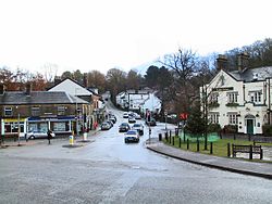
The fountain in Fountain Square was donated by the Orfords in 1837 to provide the village with clean water, the stone coming from the Jacksons Edge Quarry. It was used until the 1920s.

The village had at least one cotton mill by the mid-19th century. As the cotton industry declined, more varied employment became the norm. As of 2005, there is a paper mill and some light engineering works, but most people travel out to work.

Governance

The Crescent, Disley in 2000 Disley - The Crescent.jpg
The Crescent, Disley in 2000

The parish of Disley was included in the 19th-century as one of three parishes in Hayfield rural sanitary district, alongside Hayfield and Mellor in Derbyshire. In 1894, under the Local Government Act 1894, rural sanitary districts became rural districts, but were required to be entirely within one county or another – this led to Disley, the only Cheshire parish of the sanitary district, to form the Disley Rural District on its own – one of only a few single-parish rural districts to exist. This remained in existence until 1974, when it was merged into the new Borough of Macclesfield, whilst retaining a parish council. [1] [2]

In April 2008, a referendum was announced for Disley residents because the Borough of Macclesfield was to become part of the new Cheshire East unitary authority, as a result of major local government changes in Cheshire in April 2009. Some residents believed that the village would be better served if it were part of the neighbouring boroughs of Stockport in Greater Manchester or High Peak in Derbyshire. [7] On 8 May 2008 this referendum was held, with an overwhelming result in favour of staying within Cheshire; less than a third of electors wished to become part of the Metropolitan Borough of Stockport and an even lower proportion of the population wished the village to become part of High Peak Borough. [8] Macclesfield Borough Council was succeeded on 1 April 2009 by the new unitary authority of Cheshire East. [9]

People

Past

The Grey Cottage, where Allan Monkhouse lived from 1893 to 1902 The Grey Cottage, Disley.JPG
The Grey Cottage, where Allan Monkhouse lived from 1893 to 1902

Nearby Wyberslegh Hall (sometimes spelled Wybersley Hall), which stands between Disley and High Lane, was the birthplace of the Anglo-American novelist Christopher Isherwood. [10]

The historian A.J.P. Taylor lived in Higher Disley in the 1930s, when a lecturer at the University of Manchester. [11]

The playwright, critic, essayist and novelist Allan Monkhouse lived at the Grey Cottage on Jackson's Edge Road from 1893 to 1902, [12] and then at Meadow Bank on the same road until his death in 1936.

Lord John Hunt, who led the first successful Mount Everest expedition in 1953, also lived in Disley.[ citation needed ]

The director and writer Ian Clark was brought up in Disley [13] and attended Disley Primary School.

Present

Disley is also the home of:

Transport

Railway

Disley railway station is on the Manchester to Buxton line.

There is generally an hourly service each day to Manchester Piccadilly northbound and to Buxton southbound, with additional services at peak periods.

Roads

The A6, which connects Carlisle in Cumbria with Luton in Bedfordshire, passes through Disley; it connects the village with Stockport to the north-west and the Peak District to the south-east.

Places of interest

The Rams Head Inn in the centre of the village was built by the Legh family in c.1640, though the current exterior was built around 1840. It was formerly a lodge belonging to the Lyme Park estate. It became a main coaching stop on the Manchester to London route. In 1790, after three visits, Viscount Torrington voted it the best inn in England. The Rams Head is now a restaurant and pub, and only part of what once was its extensive stabling block still remains.

Lyme Park is in the civil parish of Lyme Handley, rather than in Disley parish, but it is sufficiently close to be associated with Disley. The hall was used by the BBC as a setting in its 1995 adaptation of Pride and Prejudice .

The Bowstones are two upright crosses on moorland above Lyme Park on the route of the Gritstone Trail. Their origins are unknown but they are believed to be religious. From here it is possible to see seven counties: Derbyshire, Lancashire, Yorkshire, Cheshire, Staffordshire, Shropshire and Clwyd.

Disley is home to Disley Cricket Club, [16] a member of the TACS Cheshire Cricket League, playing their home games at Disley Amalgamated Sports Club (DASC). The 1st XI play in Division 1 having won the Division 2 championship in 2014 and Division 3 in 2013.

Moorside Golf Club, Higher Disley, first appeared in the 1930s. The club continued until the late 1950s but is now defunct. [17]

Stanley Hall Farmhouse is a Grade-II-listed building from the 16th-century. [18] Stanley Hall was given to the Stanleys by the Black Prince in 1388 and bought by the Leghs in 1488. Part of the barn, also Grade II listed, [19] was used as the first clubhouse of the Disley golf club.

Education

Disley has a primary school, Disley Primary School, [20] which in 2020 became an academy as part of The TRUE Learning Partnership, and two nurseries, Blue Grass Purple Cow [21] and Disley Under Fives. [22]

See also

Related Research Articles

<span class="mw-page-title-main">Lyme Park</span> Grade I listed building in Cheshire East, UK

Lyme Park is a large estate south of Disley, Cheshire, England, managed by the National Trust and consisting of a mansion house surrounded by formal gardens and a deer park in the Peak District National Park. The house is the largest in Cheshire, and is recorded in the National Heritage List for England as a designated Grade I listed building.

<span class="mw-page-title-main">Upper Goyt Valley</span> Valley in the Peak District of England

The Upper Goyt Valley is the southern section of the valley of the River Goyt in North West England.

<span class="mw-page-title-main">New Mills</span> Human settlement in England

New Mills is a town in the Borough of High Peak, Derbyshire, England, 8 miles (13 km) south-east of Stockport and 13 miles (21 km) from Manchester at the confluence of the River Goyt and Sett. It is close to the border with Cheshire and above the Torrs, a 70 feet (21 m) deep gorge cut through carboniferous sandstone, on the north-western edge of the Peak District National Park.

<span class="mw-page-title-main">Macclesfield (borough)</span>

Macclesfield was, from 1974 to 2009, a local government district with borough status in Cheshire, England. It included the towns of Bollington, Knutsford, Macclesfield and Wilmslow and within its wider area the villages and hamlets of Adlington, Disley, Gawsworth, Kerridge, Pott Shrigley, Poynton, Prestbury, Rainow, Styal, Sutton and Tytherington.

<span class="mw-page-title-main">Bramhall</span> Human settlement in England

Bramhall is an area in the Metropolitan Borough of Stockport, Greater Manchester, England. Historically in Cheshire, it had a population of 17,436 at the 2011 Census.

<span class="mw-page-title-main">Alderley Edge</span> Village and civil parish in England

Alderley Edge is a village and civil parish in Cheshire, England. In 2011, it had a population of 4,780.

<span class="mw-page-title-main">Whaley Bridge</span> Town in the High Peak, Derbyshire, England

Whaley Bridge is a town and civil parish in the High Peak district of Derbyshire, England. It is situated on the River Goyt, 16 miles (26 km) south-east of Manchester, 7 miles (11 km) north of Buxton, 9 miles (14 km) north-east of Macclesfield and 28 miles (45 km) west of Sheffield. It had a population of 6,455 at the 2011 census, including Furness Vale, Horwich End, Bridgemont, Fernilee, Stoneheads and Taxal.

<span class="mw-page-title-main">Marple, Greater Manchester</span> Town in Greater Manchester, England

Marple is a town in the Metropolitan Borough of Stockport, Greater Manchester, England. It is on the River Goyt, 9 miles (14 km) south-east of Manchester, 9 miles (14 km) north of Macclesfield and 4 miles (6 km) south-east of Stockport. In 2011, it had a population of 23,686.

<span class="mw-page-title-main">High Lane, Greater Manchester</span> Human settlement in England

High Lane is a village in the Metropolitan Borough of Stockport, Greater Manchester, England, on the Macclesfield Canal, 5 miles (8 km) from Stockport.

<span class="mw-page-title-main">Poynton</span> Town in Cheshire, England

Poynton is a town in the civil parish of Poynton-with-Worth, in the Cheshire East district, in the ceremonial county of Cheshire, England, on the easternmost fringe of the Cheshire Plain, 11 miles (18 km) south-east of Manchester, 7 miles (11 km) north of Macclesfield and 5 miles (8 km) south of Stockport. From 1974 to 2009 it was in Macclesfield district.

<span class="mw-page-title-main">Mellor, Greater Manchester</span> Human settlement in England

Mellor is a village in Greater Manchester, England, lying between Marple Bridge and New Mills, Derbyshire.

<span class="mw-page-title-main">Adlington, Cheshire</span> Human settlement in England

Adlington is a village and civil parish in the unitary authority of Cheshire East and the ceremonial county of Cheshire, England. It is known as Eduluintune in the Domesday Book. According to the 2001 census the civil parish had a population of 1,081 people across 401 households. There is a mixed, non-denominational primary school in the village.

<span class="mw-page-title-main">Marple Bridge</span> Human settlement in England

Marple Bridge is a district of Marple in the Metropolitan Borough of Stockport, Greater Manchester, England, on the River Goyt, which runs through the centre of the village.

<span class="mw-page-title-main">Buxton line</span> Railway line in the UK

The Buxton line is a railway line in Northern England, connecting Manchester with Buxton in Derbyshire. Passenger services on the line are currently operated by Northern Trains.

<span class="mw-page-title-main">Kettleshulme</span> Village and civil parish in England

Kettleshulme is a village and former civil parish, now in the parish of Kettleshulme and Lyme Handley, in the Cheshire East district, in the ceremonial county of Cheshire, England. The village is close to the border with Derbyshire, on the B5470 road from Whaley Bridge to Macclesfield in the valley of the Todd Brook, a tributary of the River Goyt. In 2001 the parish had a population of 353.

<span class="mw-page-title-main">Knutsford (UK Parliament constituency)</span> Parliamentary constituency in the United Kingdom, 1885–1983

Knutsford was a county constituency in Cheshire which returned one Member of Parliament (MP) to the House of Commons of the Parliament of the United Kingdom from 1885 until it was abolished for the 1983 general election.

<span class="mw-page-title-main">County Borough of Stockport</span> Former municipal borough in present-day town of Stockport

Stockport County Borough was a county-level local authority between 1889 and 1974.

<span class="mw-page-title-main">Cheshire East</span> Borough in England

Cheshire East is a unitary authority area with borough status in Cheshire, England. The local authority is Cheshire East Council. Towns within the area include Crewe, Macclesfield, Congleton, Sandbach, Wilmslow, Handforth, Knutsford, Poynton, Bollington, Alsager and Nantwich. The council is based in the town of Sandbach.

Disley is a civil parish in Cheshire East, England. It contains 56 buildings that are recorded in the National Heritage List for England as designated listed buildings. Of these, one is listed at Grade II*, the middle grade, and the others are at Grade II. Apart from the village of Disley, the parish is rural. The Peak Forest Canal, and the River Goyt run through the parish. There are four listed bridges associated with these waterways, three over the canal, and one over the river. Lyme Park lies mainly in the adjacent parish of Lyme Handley, but two of its entrances lie within Disley parish, including listed lodges and gate piers. Otherwise, most of the listed buildings are houses, cottages, farmhouses and farm buildings. The other listed items include a church and associated structures, public houses, a drinking fountain, a war memorial, a milestone, and a telephone kiosk.

<span class="mw-page-title-main">Peak District Boundary Walk</span> Long distance footpath in England

The Peak District Boundary Walk is a circular 190-mile (310 km) walking trail, starting and finishing at Buxton and broadly following the boundary of the Peak District, Britain's first national park. The route was developed by the Friends of the Peak District and was launched on 17 June 2017.

References

  1. 1 2 3 The Parish of Disley (Official Guide). Disley Parish Council. 1994.
  2. 1 2 "Borough of Macclesfield: Parish Clerks". Borough of Macclesfield. Archived from the original on 11 April 2008. Retrieved 21 April 2007.
  3. "Civil Parish population 2011". Neighbourhood Statistics. Office for National Statistics. Retrieved 13 March 2016.
  4. The Ordnance Survey (2006). Sheet OL1: The Peak District, Dark Peak area. Ordnance Survey Explorer Map: 1:25000 series. Southampton: Ordnance Survey. ISBN   0-319-23777-X.
  5. "Disley". The Key To English Place Names. English Place Name Society. Archived from the original on 16 October 2015. Retrieved 9 May 2012.
  6. 1 2 3 "History of Disley". Disley Parish Council. 28 May 2013. Retrieved 12 August 2019.
  7. "Village vote on council change". Manchester Evening News . 12 April 2010. Retrieved 21 August 2019.
  8. "Disley Parish Council – Declaration of Result of Poll". Disley Parish Council. 8 May 2008. Archived from the original (.doc) on 21 July 2011. Retrieved 24 May 2008.
  9. Cheshire (Structural Changes) Order 2008 Archived 17 May 2009 at the Wayback Machine
  10. Jolly, Margaretta (2001). Encyclopedia of Life Writing: Autobiographical and Biographical Forms. Fitzroy Dearborn Publishers. p. 475. ISBN   1-57958-232-X.
  11. Morley, Paul (2013). The North (And Almost Everything In It). Bloomsbury Publishing. p.  289. ISBN   978-0747578161.
  12. Blue plaque on building reads: "Literary editor at the Manchester Guardian Allan Noble Monkhouse 1858–1936 lived at the Grey Cottage 1893–1902. Novelist and playwright of the "Manchester School" of drama."
  13. "Clark family history". mandmclark.com. Archived from the original on 17 February 2015. Retrieved 7 March 2017.
  14. "Storeys add to GB cycling golds". BBC. 10 September 2008. Retrieved 29 October 2008.
  15. "Awesome GB sprint team take gold". BBC. 15 August 2008. Retrieved 29 October 2008.
  16. "Disley Cricket Club". www.disleycc.co.uk. Retrieved 8 August 2008.
  17. "Moorside Golf Club, Higher Disley, Cheshire (1930–1950s)". Golf's Missing Links. Retrieved 21 August 2019.
  18. Historic England. "Stanley Hall (Grade II) (1231812)". National Heritage List for England . Retrieved 21 August 2019.
  19. Historic England. "Barn attached at right angles to Stanley Hall (Grade II) (1277457)". National Heritage List for England. Retrieved 21 August 2019.
  20. "Home page". Disley Primary School. Retrieved 7 May 2021.
  21. "Blue Grass Purple Cow".
  22. "Disley Under Fives".