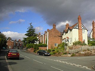
Farndon is a village and civil parish in the unitary authority of Cheshire West and Chester and the ceremonial county of Cheshire, England. It is on the banks of the River Dee, south of Chester, which here forms the England–Wales border. The Welsh village of Holt lies just over the River Dee from Farndon.
Ifield is a former village and now one of 14 neighbourhoods within the town of Crawley in West Sussex, England. Ifield is in the west of the town and is bordered by Ifield West, Horsham, Langley Green to the north east, West Green to the east across the ring road and Gossops Green and Bewbush to the south across the Arun Valley railway line.
Sir Hugh Calveley was an English knight and commander, who took part in the Hundred Years' War, gaining fame during the War of the Breton Succession and the Castilian Civil War. He held various military posts in Brittany and Normandy. He should not be confused with his nephew, also Sir Hugh Calveley, who died in June 1393 and was Member of Parliament for Rutland.
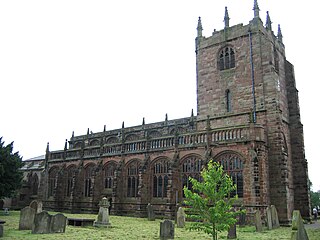
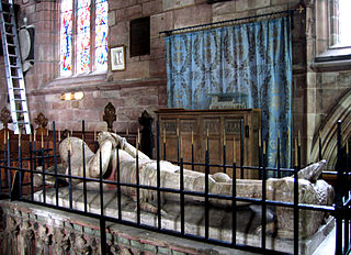
St Boniface's Church stands prominently in the village of Bunbury, Cheshire, England. It is recorded in the National Heritage List for England as a designated Grade I listed building. The church dates mainly from the 14th century. Its features include the Ridley chapel, the alabaster chest tomb of Sir Hugh Calveley and the tomb of Sir George Beeston. Raymond Richards, author of Old Cheshire Churches, considers it is architecturally one of the most important examples of its period in Cheshire. Alec Clifton-Taylor includes it in his list of 'best' English parish churches, and Simon Jenkins assigns it two stars in his book England's Thousand Best Churches. It is an active Anglican parish church in the diocese of Chester, the archdeaconry of Chester and the deanery of Malpas. Its benefice is combined with that of St Jude, Tilstone Fearnall.

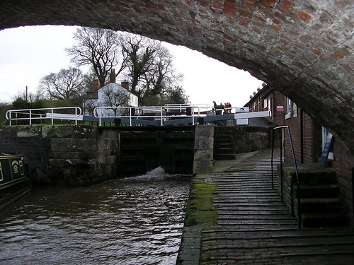
Calveley is a village and former civil parish, now in the parish of Alpraham and Calveley, in the unitary authority area of Cheshire East and the ceremonial county of Cheshire, England. The village lies 5½ miles to the north west of Nantwich. The parish also includes parts of the settlements of Barrets Green and Wardle Bank. The total population is 280 people. The area is largely agricultural and includes a short stretch of the Shropshire Union Canal. There is an Anglican parish church, a primary school and a public house. Nearby villages include Alpraham, Bunbury, Haughton and Wardle. In 2011 the parish had a population of 280.

Cholmondeston is a village and civil parish in the unitary authority of Cheshire East and the ceremonial county of Cheshire, England. The village lies 5 miles (8 km) to the northwest of Nantwich. Nearby villages include Aston juxta Mondrum, Barbridge, Calveley and Wettenhall. The Middlewich Branch of the Shropshire Union Canal and the Crewe–Chester railway line run through the civil parish. The area is predominantly rural, with a total population of around 150 in 2001, increasing to 175 at the 2011 Census.

Peckforton is a scattered settlement and civil parish in the unitary authority of Cheshire East and the ceremonial county of Cheshire, England. The settlement is located 6.5 miles (10.5 km) to the north east of Malpas and 7.5 miles (12.1 km) to the west of Nantwich. The civil parish covers 1,754 acres (710 ha), with an estimated total population of 150 in 2006. The area is predominantly agricultural. Nearby villages include Bulkeley to the south, Beeston to the north, Higher Burwardsley to the west, Spurstow to the east and Bunbury to the north east.

Spurstow is a village and civil parish in the unitary authority of Cheshire East and the ceremonial county of Cheshire, England, which is located 6½ miles to the north west of Nantwich. The parish also includes the settlement of Spurstow Sketh and part of Radmore Green. The total population is a little over 400 people. Nearby villages include Bunbury, Haughton and Peckforton. The parish is mentioned in the Domesday Book of 1086 and contains a salt spring, which was formerly used as a spa.

Stoke is a former civil parish, now in the parish of Stoke and Hurleston, in the unitary authority area of Cheshire East and the ceremonial county of Cheshire, England. The parish was predominantly rural with a total population of around 200, measured with the inclusion of Hurleston at 324 in the 2011 Census. The largest settlement was Barbridge, which lies 3½ miles to the north west of Nantwich. The parish also included the small settlements of Stoke Bank and Verona. Nearby villages include Aston juxta Mondrum, Burland, Calveley, Haughton, Rease Heath and Wardle.

Wardle is a village and civil parish in the unitary authority of Cheshire East and the ceremonial county of Cheshire, England. The village lies on the Shropshire Union Canal, north west of Barbridge Junction, and is 4 miles to the north west of Nantwich, and the parish also includes part of the small settlement of Wardle Bank. The total population is around 250. RAF Calveley was a flight-training station during the Second World War, and the Mark III radio telescope stood on the airfield site in 1966–96. The modern civil parish includes Wardle Industrial Estate and is otherwise largely agricultural. Nearby villages include Barbridge, Calveley and Haughton.

Wettenhall is a village and civil parish in the unitary authority of Cheshire East and the ceremonial county of Cheshire, England. The village lies 3½ miles to the south west of Winsford and 6 miles to the north west of Crewe. The parish also includes the settlements of Chapel Green and Woodside. Nearby villages include Alpraham, Calveley, Cholmondeston, Church Minshull, Little Budworth and Tarporley. According to the 2001 census, the parish had a population of 135, increasing to 192 at the 2011 Census.
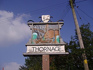
Thornage is a village and a civil parish in the English county of Norfolk. The village is 2.7 miles south-west of Holt, 23.2 miles north-west of Norwich and 11.3 miles east of Fakenham, and straddles the B1110 road between Holt and Guist. The nearest railway station is at Sheringham for the Bittern Line which runs between Sheringham, Cromer and Norwich. The nearest airport is at Norwich International Airport.

Bunbury Mill is a watermill located to the east of the village of Bunbury, Cheshire, England. After being at risk of demolition, it has been restored as a working museum. The structure is designated by Historic England as a Grade II listed building.
Calveley Church is in the village of Calveley, Cheshire, England. It is an active Anglican church in the parish of St Boniface, Bunbury, the deanery of Malpas, the archdeaconry of Chester, and the diocese of Chester. The church is recorded in the National Heritage List for England as a designated Grade II listed building.

Calveley railway station was located in the centre of the small village of Calveley, Cheshire, England.
Bunbury is a civil parish in Cheshire East, England. It contains 31 buildings that are recorded in the National Heritage List for England as designated listed buildings. Of these, one is listed at Grade I, the highest grade, one is listed at Grade II*, the middle grade, and the others are at Grade II. The parish contains the settlements of Bunbury, Bunbury Heath, and Lower Bunbury, with surrounding countryside. Many of the listed buildings are houses, cottages, farmhouses and farm buildings, some dating back to the 17th century and timber-framed. The other buildings are a church and associated structures, a public house, a former school, an active school, and a watermill.

Calthorpe is a small village and former civil parish, now in the parish of Erpingham, in the North Norfolk district, in the county of Norfolk, England. The village is located 0.5 miles (0.80 km) west of the village of Erpingham, 3.4 miles (5.5 km) north of the nearest town of Aylsham and is 15.8 miles (25.4 km) north of the nearest city of Norwich. The nearest railway station is at Gunton for the Bittern Line which runs between Sheringham, Cromer and Norwich and is 7.8 miles (12.6 km) from the village. The nearest airport is Norwich International 14.2 miles (22.9 km) south of the village. In 1931 the parish had a population of 143.
Hugh Calveley, of Lea, Cheshire, was an English politician who represented Liverpool as a Member of Parliament in 1601 during the latter years of the reign of Elizabeth I. The surname is often misspelt as Calverley which is a Yorkshire based surname, distinct and not in any way connected. The correct spelling of the Cheshire family from which Sir High is descended is Calveley.
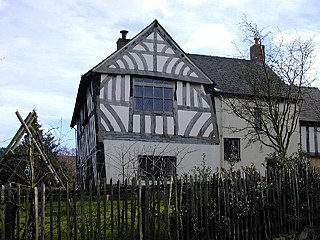
The Chantry House, also known as the Chantry Priests' (or Priest's) House and formerly the Old School House, is a medieval half-timbered or "black-and-white" house, dating from around 1527, in Bunbury, Cheshire, England. It was originally associated with the chantry chapel in the nearby parish church of St Boniface, founded by Sir Ralph Egerton. After the chantry's dissolution, it became associated with Thomas Aldersey's grammar school. The Chantry House is an early surviving example of a residential timber-framed building in Cheshire, with many typically medieval features. It is listed at grade II* for "the quality of framing throughout."

Thomas Aldersey was an English merchant, haberdasher, member of Parliament and philanthropist. A contemporary description placed him among the "wisest and best merchants in London", and he was particularly known for his efforts to set the Protestant colony of Emden on a secure trade footing. His charitable works included the establishment of a free grammar school at his birthplace of Bunbury in Cheshire.


