Early recorded variations of the name Wheelock have included Quelok, Qwelok, Whelok, Whelocke, with later forms using Wheelock Watter and Wheelock Brooke. The name is said to mean "winding river" and it is reported to have based on the Old Welsh word chwylog, the chwyl part of which means "a turn, a rotation, a course", with an adjective suffix of og.[1] The river has given its name to the large village of Wheelock.[2]
Origin
In his book The History of Cheshire (1778), Daniel King et al write:
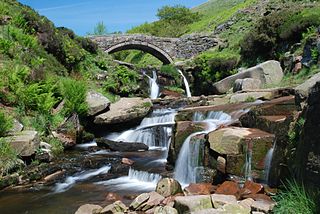
"The Wheelock is also engendered of three small rivers, which spring not far from Mowcop Hill. The first cometh from Morton Hall, in Astbury parish, the other two from Lawton and Rode Hall, and meet together not far from Sandbach. From whence it passeth to the town and manor place of Wheelock, belonging to Mr. Liversedge; to Elton, where it taketh in the Fulbrook, that cometh out of Oke-hanger Mere; and then goeth to Warmingham, Sutton Mill, Wheelock Mill, and not far off falleth into the Dane at Croxton. This is here to be noted, that like as the water which falleth down on the west-side of Mowcop engendereth the Wheelock, so doth that which falleth on the east-side make the very head of the famous river of Trent. The whole course of the Wheelock is about twelve miles."[3]
Dodgson, J. McN. (1970a). The place-names of Cheshire. Part one: Country name, regional and forest names, river names, road names, the place-names of Macclesfield hundred. Cambridge: Cambridge University Press. ISBN0-521-07703-6.
Dodgson, J. McN. (1970b). The place-names of Cheshire. Part two: The place-names of Bucklow Hundred and Northwich Hundred. Cambridge: Cambridge University Press. ISBN0-521-07914-4.
The River Dane is a tributary of the River Weaver that originates in the Peak District area of England. The name of the river is probably from the Old Welsh dafn, meaning a "drop or trickle", implying a slow-moving river.
Sandbach is a market town and civil parish in the Cheshire East borough of Cheshire, England. The civil parish contains four settlements: Sandbach, Elworth, Ettiley Heath and Wheelock. It lies close to the cities of Stoke on Trent, Manchester, Chester, Liverpool and Salford.
Middlewich is a town in the unitary authority of Cheshire East and the ceremonial county of Cheshire, England. It is located 19.2 miles (30.9 km) east of Chester, 2.9 miles (4.7 km) east of Winsford, 5.3 miles (8.5 km) south-east of Northwich and 4.7 miles (7.6 km) north-west of Sandbach. The population at the 2011 Census was 13,595. Middlewich, together with Northwich and Winsford, forms part of the Central Cheshire conurbation, with an estimated 2023 population of 130,000.
Congleton is a parliamentary constituency in Cheshire, represented in the House of Commons of the UK Parliament since 2010 by Fiona Bruce of the Conservative Party.
Tushingham cum Grindley is a former civil parish, now in the parish of Tushingham-cum-Grindley, Macefen and Bradley, in the unitary authority of Cheshire West and Chester and the ceremonial county of Cheshire, England. The parish contained the village of Tushingham and the hamlet of Bell o' th' Hill. According to the 2001 UK census, the total population of the civil parish was 166, rising to 187 at the 2011 Census. The civil parish was abolished in 2015 to form Tushingham-cum-Grindley, Macefen and Bradley.
Haslington is a village and civil parish in the unitary authority of Cheshire East and the ceremonial county of Cheshire, England. It lies about 2 miles (3.2 km) north-east of the much larger railway town of Crewe and approximately 4 miles (6.4 km) south of Sandbach. The village was originally bisected by the A534 road that links Crewe with Sandbach, however, this road has now been re-routed to bypass the village to the north-west. The village is also a close neighbour to a number of small towns and villages, and is approximately 6 miles (9.7 km) from the Elizabethan market town of Nantwich.
Middlewich, a town in northwest England, lies on the confluence of three rivers – the Dane, the Croco and the Wheelock. Most importantly for the history of salt making, it also lies on the site of a prehistoric brine spring.
Tarporley is a large village and civil parish in Cheshire, England. The civil parish also contains the village of Rhuddall Heath. Tarporley is bypassed by the A49 and A51 roads.
Sandbach railway station serves the town of Sandbach in Cheshire, England. The station is sited 4+3⁄4 miles (8 km) north-east of Crewe, on the Crewe to Manchester Line. Although the station is named Sandbach, it is located in the local residential suburb of Elworth on the A533 road, which links the town with Middlewich and Northwich.
Wheelock is a large village in the civil parish of Sandbach which is in the unitary authority of Cheshire East and the ceremonial county of Cheshire, England. It is south of Sandbach on the road to Crewe. It was named after the River Wheelock.
The River Croco is a small river in Cheshire in England. It starts as lowland field drainage west of Congleton, flows along the south edge of Holmes Chapel, and joins the River Dane at Middlewich. It is about 8 miles (13 km) long.
Middlewich is one of the Wich towns in Cheshire, England.
Stanthorne is a village and former civil parish, now in the parish of Stanthorne and Wimboldsley, in the Cheshire West and Chester district, in the ceremonial county of Cheshire, England, 2 miles west of Middlewich. The A54 runs through the village, connecting it to the railway station at Winsford. At the 2011 census, it had a population of 153.
Bradwall is a small village and civil parish in the unitary authority of Cheshire East, about 2 mi (3.2 km) northwest of Sandbach in the ceremonial county of Cheshire, England, and about 20 mi (32 km) south of Manchester. According to the 2011 census, the population of the entire parish was 182. The area is predominantly agricultural, with no manufacturing or retail outlets.
The ancient parishes of Cheshire were the group of parishes that existed in the English county of Cheshire, roughly within the period of 1200–1800. Initially, the ancient parishes had only an ecclesiastical function, but reforms initiated by King Henry VIII, developed by Queen Elizabeth I and expanded by later legislation led them to acquire various secular functions that eventually led to a split between the ecclesiastical parishes and the purely civil parishes that exist today.
The A535 road is a non-primary route in England that runs from Holmes Chapel, Cheshire to Alderley Edge, Cheshire. It passes through the Dane River valley. It is the main road that gives access to the Jodrell Bank Observatory and the Quinta Arboretum, planted by Sir Bernard Lovell in 1948.
Ettiley Heath is a village in the civil parish of Sandbach which is in the unitary authority of Cheshire East and the ceremonial county of Cheshire, England. The Sandbach ward is called Ettiley Heath and Wheelock. The population of this ward at the 2011 Census was 4,409. It is west of Sandbach.
This page is based on this Wikipedia article Text is available under the CC BY-SA 4.0 license; additional terms may apply. Images, videos and audio are available under their respective licenses.