
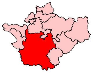
Crewe and Nantwich is a constituency in the House of Commons of the UK Parliament. It is located in Cheshire. It was created in 1983, and has been represented since 2019 by Kieran Mullan of the Conservative Party.
Eddisbury is a constituency in Cheshire represented in the House of Commons of the UK Parliament since 2019 by Edward Timpson, a Conservative.

Austerson is a civil parish in the unitary authority of Cheshire East and the ceremonial county of Cheshire, England, lying immediately south of the town of Nantwich and north of the village of Audlem. Predominantly rural with scattered farms, the civil parish includes the small settlement of Old Hall Austerson at SJ656493, about two miles south of Nantwich centre. In 2001, the total population was a little under 150, increasing to 194 at the 2011 Census. Nearby villages include Broomhall Green, Hack Green, Hankelow, Sound Heath and Stapeley.
Baddington is a civil parish in the unitary authority of Cheshire East and the ceremonial county of Cheshire, England, which lies immediately to the south-west of Nantwich and north of Audlem. Predominantly rural with scattered farms, the civil parish has a total population of around 100 people, increasing to 212 at the 2011 Census, and includes the dispersed settlement of Hack Green, the site of a former RAF decoy station, radar station and Home Defence regional headquarters. Nearby villages include Aston, Broomhall Green, Hankelow, Ravensmoor, Sound Heath and Stapeley.

Buerton is a village at SJ685435 and civil parish in the unitary authority of Cheshire East and the ceremonial county of Cheshire, England, about 7 miles south of the town of Nantwich and 1½ miles east of the village of Audlem, on the border with Shropshire. The parish also includes the small settlements of Hankins Heys, Moblake, Pinder's End and Three Wells, as well as parts of Chapel End, College Fields, Kinsey Heath, Longhill, Raven's Bank, Sandyford and Woolfall. In 2001, the total population was a little under 500, which had increased marginally to 503 at the 2011 Census. Nearby villages include Adderley, Audlem, Bridgemere, Hankelow, Hatherton, Hunsterson and Woore.

Burland is a village and civil parish in the unitary authority of Cheshire East and the ceremonial county of Cheshire, England, about 2+1⁄2 miles west of Nantwich. The civil parish also includes the small settlements of Burland Lower Green, Burland Upper Green, Hollin Green and Stoneley Green, as well as parts of Gradeley Green and Swanley. The eastern part of the village of Ravensmoor also falls within the civil parish.

Marbury is a small village located at SJ560457 in the civil parish of Marbury cum Quoisley, within the unitary authority of Cheshire East and the ceremonial county of Cheshire, England. It is administered jointly with the adjacent civil parishes of Norbury and Wirswall. The village lies around 3 miles (5 km) north east of Whitchurch in Shropshire and 7 miles (11 km) south west of Nantwich in Cheshire. Nearby villages include Malpas, No Man's Heath, Norbury, Wirswall and Wrenbury. The civil parish borders Shropshire and covers 2,168 acres (877 ha); it also contains the small settlements of Hollins Lane, Marley Green and Quoisley, as well as parts of Hollyhurst and Willeymoor. The total population was just under 250 in 2001, and – combined with Wirswall – 352 in 2011.

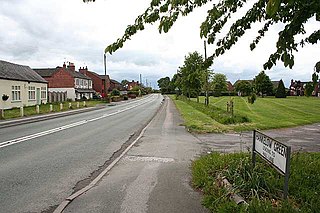
Wrenbury-cum-Frith is a village and civil parish in the unitary authority of Cheshire East, and the ceremonial county of Cheshire, England. It lies on the River Weaver, around 8.5 miles south-west of Crewe.

Norbury is a hamlet and civil parish in Cheshire, England, which includes the small settlements of Gauntons Bank, Hurst Green, Swanwick Green, Norbury Common and Holtridge, with a total population of nearly 200 people in 2011. The hamlet of Norbury lies around 5 miles (8 km) north of Whitchurch, Shropshire. Nearby villages include No Man's Heath, Marbury and Wrenbury.

Chorley is a hamlet and civil parish in the unitary authority of Cheshire East and the ceremonial county of Cheshire, England. The hamlet lies 5 miles to the west of Nantwich and 6 miles to the north east of Malpas. The total population is a little over a hundred people. Nearby villages include Faddiley, Norbury, Ravensmoor and Wrenbury.

Hunsterson is a hamlet and civil parish in the unitary authority of Cheshire East and the ceremonial county of Cheshire, England. The hamlet is located 2¾ miles to the north east of Audlem and 6 miles to the south of Crewe. The parish also includes the settlements of Brown Moss, Four Lane End, Foxes Bank and Whittaker's Green. The total population is a little over 160. Nearby villages include Audlem, Buerton, Hatherton and Hankelow.

Newhall is a village and civil parish in the unitary authority of Cheshire East and the ceremonial county of Cheshire, England. The village lies 3½ miles to the west of Audlem and 5 miles to the south west of Nantwich. The parish also includes the village of Aston, and the small settlements of Aston Heath, Barnett Brook, Brown's Bank, Dodd's Green, Grandford, Grindley Green, Hollingreen, Kingswood Green, Maiden Estate, Salesbrook, Sheppenhall and part of Sandford. Nearby villages include Audlem and Wrenbury.
Sound is a hamlet and civil parish in the unitary authority of Cheshire East and the ceremonial county of Cheshire, England. The hamlet is located 3+1⁄4 miles (5.2 km) to the south west of Nantwich. The civil parish covers 1,089 acres (441 ha) and also includes the small settlements of Newtown and Sound Heath, with a total population at the 2011 Census of 239. Nearby villages include Aston, Ravensmoor and Wrenbury.

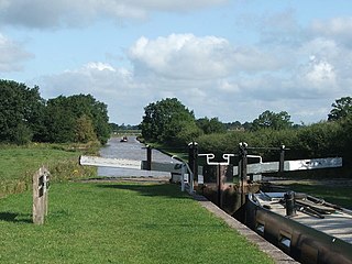
Wardle is a village and civil parish in the unitary authority of Cheshire East and the ceremonial county of Cheshire, England. The village lies on the Shropshire Union Canal, north west of Barbridge Junction, and is 4 miles to the north west of Nantwich, and the parish also includes part of the small settlement of Wardle Bank. The total population is around 250. RAF Calveley was a flight-training station during the Second World War, and the Mark III radio telescope stood on the airfield site in 1966–96. The modern civil parish includes Wardle Industrial Estate and is otherwise largely agricultural. Nearby villages include Barbridge, Calveley and Haughton.

Hurleston is a civil parish in the unitary authority of Cheshire East and the ceremonial county of Cheshire, England, which lies to the north west of Nantwich. The parish is predominantly rural with scattered farms and buildings and no settlements. Nearby villages include Barbridge, Burland, Radmore Green, Rease Heath and Stoke Bank.
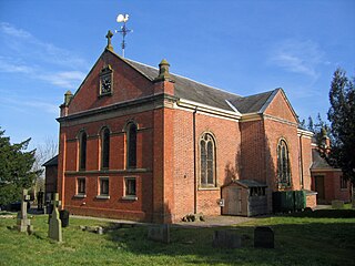
St Mary's and St Michael's Church is in the village of Burleydam in the civil parish of Dodcott cum Wilkesley, Cheshire, England. The church is some 1.5 miles (2 km) to the southeast of Combermere Abbey. It is recorded in the National Heritage List for England as a designated Grade II listed building. It is an active Anglican parish church in the diocese of Chester, the archdeaconry of Macclesfield and the deanery of Nantwich. Its benefice is combined with those of St Michael, Baddiley, and St Margaret, Wrenbury.
Acton was an ancient parish in the Nantwich Hundred of Cheshire, England.
Hankelow is a village and civil parish in the unitary authority of Cheshire East and the ceremonial county of Cheshire, England. The village lies on the A529, around 1.25 miles (2.0 km) north east of Audlem and 4.5 miles (7.2 km) south of Nantwich. The civil parish has an area 369 hectares and also includes the small settlement of The Dell and part of Corbrook, with a total population of just over 260 in 2011. Nearby villages include Aston, Broomhall Green, Sound, Hatherton and Buerton in Cheshire and Woore in Shropshire.

A total of 21 buildings and other structures in the English civil parish of Dodcott cum Wilkesley have been officially designated as listed buildings for their "special architectural and historic interest". Dodcott cum Wilkesley is in the Cheshire East division of the ceremonial county of Cheshire, situated on the Cheshire Plain at the border with Shropshire. The civil parish is predominantly rural, with many scattered minor settlements, the largest of which is the small village of Burleydam. One of the listed buildings is classified by English Heritage as being in grade I, meaning "of exceptional interest, sometimes considered to be internationally important" ; two are in grade II* and the remainder in grade II.

Burleydam is a small English village in the civil parish of Dodcott cum Wilkesley in the unitary authority of Cheshire East and the ceremonial county of Cheshire, near the border with Shropshire. It is on the A525. The nearest town is Whitchurch in Shropshire, around 8 km (5 miles) to the west; nearby small settlements include Barnett Brook, Grindley Green and Royal's Green in Dodcott cum Wilkesley; Dodd's Green and Newhall in Newhall civil parish; and Old Woodhouses and New Woodhouses in Shropshire.


