
Mow Cop Castle is a folly at Mow Cop in the civil parish of Odd Rode, Cheshire, England. It is designated as a Grade II listed building on the National Heritage List for England. The ridge, upon which the castle sits, forms the boundary between the counties of Cheshire and Staffordshire, the dioceses of Chester and Lichfield and the ecclesiastical provinces of Canterbury and York.

Alsager is a town and civil parish in the unitary authority of Cheshire East in Cheshire, England. It is located to the north-west of Stoke-on-Trent and east of Crewe. The town's population was 13,389 at the 2021 census.

Biddulph is a town in Staffordshire, England, 8.5 miles (14 km) north of Stoke-on-Trent and 4.5 miles (7 km) south-east of Congleton, Cheshire.

The Borough of Newcastle-under-Lyme is a local government district with borough status in Staffordshire, England.
Audley Rural is a parish of Staffordshire, England, located four miles to the north-west of the town of Newcastle-under-Lyme. It is predominantly a rural area, of which Audley is the centre. Other settlements are Alsagers Bank, Bignall End, Halmer End, Miles Green, Scot Hay and Wood Lane, and the outlying hamlets of Dunkirk, Mill End, Shraley Brook, Eardley End, Coopers Green, Butters Green and Crackley Gates. The population of this parish at the 2011 census was 8,437.

Rode Heath is a small village in the civil parish of Odd Rode, near Alsager and within the unitary authority of Cheshire East and the ceremonial county of Cheshire, England. According to the 2001 census, Rode Heath had a population of 2,150. In the 2011 census the figure had dropped to 2,019 and a 2016 estimate put the population at 1,943. The village was previously two villages, Rode Heath and Thurlwood. Since extensive housing developments in Thurlwood the two are known simply as Rode Heath.

Austerson is a civil parish in the unitary authority of Cheshire East and the ceremonial county of Cheshire, England, lying immediately south of the town of Nantwich and north of the village of Audlem. Predominantly rural with scattered farms, the civil parish includes the small settlement of Old Hall Austerson at SJ656493, about two miles south of Nantwich centre. In 2001, the total population was a little under 150, increasing to 194 at the 2011 Census. Nearby villages include Broomhall Green, Hack Green, Hankelow, Sound Heath and Stapeley.
Barthomley is a village and ancient parish, and is now a civil parish in the unitary authority of Cheshire East and the ceremonial county of Cheshire, England. According to the 2001 and the 2011 census' the parish had a population of 202. The village is situated near junction 16 of the M6 motorway and by the border with Staffordshire. It is about three miles south-west of Alsager.

Wrenbury-cum-Frith is a village and civil parish in the unitary authority of Cheshire East, and the ceremonial county of Cheshire, England. It lies on the River Weaver, around 8.5 miles south-west of Crewe.

Newbold Astbury is a village and civil parish in the unitary authority of Cheshire East and the ceremonial county of Cheshire, in the north-west of England.
Wheelock is a large village in the civil parish of Sandbach which is in the unitary authority of Cheshire East and the ceremonial county of Cheshire, England. It is south of Sandbach on the road to Crewe. It was named after the River Wheelock.

The South Cheshire Way is a 34-mile (55 km) long-distance footpath running east–west mainly through Cheshire, England, although parts lie in Shropshire and Staffordshire. The western section from Grindley Brook, near Whitchurch, runs through farmland; the eastern section from Mow Cop, near Biddulph, runs through low hills. The footpath is waymarked with black-and-yellow discs inscribed 'SCW'. It is covered by the Ordnance Survey Explorer series 257 and 268 maps, which denote it with a green lozenge.

Church Lawton is a village and located in the unitary authority of Cheshire East and the ceremonial county of Cheshire in England. Its location is such that its eastern boundary forms part of the county boundary between Cheshire and Staffordshire and, because of its close proximity to Stoke-on-Trent, the parish has a Stoke postcode. In addition to ribbon development connecting Kidsgrove with Scholar Green, the parish also contains the hamlets of Lawton Gate, Lawton Heath and Lawton Heath End, and the Lawton Hall estate. According to the 2001 census, the population of the entire parish was 2,201.

North Rode is a small village and civil parish in the unitary authority of Cheshire East and the ceremonial county of Cheshire, England. According to the 2001 census, the population of the entire civil parish was 178.
Brereton is a civil parish in Cheshire, England. At the 2011 census, the population was 1,190. Brereton is mentioned in the Domesday book as the Manor of Bretune. The civil parish includes the hamlets of Brereton Green, Brereton Heath, Smethwick Green, Medhurst Green, Sandlow Green and Davenport.

Cheshire East is a unitary authority area with borough status in Cheshire, England. The local authority is Cheshire East Council, which is based in the town of Sandbach. Other towns within the area include Crewe, Macclesfield, Congleton, Wilmslow, Nantwich, Poynton, Knutsford, Alsager, Bollington and Handforth.

Chorlton is a village and former civil parish, now in the parish of Hough and Chorlton, in the unitary authority area of Cheshire East and the ceremonial county of Cheshire, England. The village lies 4 miles (6.4 km) to the south east of Crewe. Nearby villages include Hough, Shavington, Weston and Wybunbury in Cheshire and Betley in Staffordshire. In 2011 the parish had a population of 897.
Wybunbury is a village and civil parish in the unitary authority of Cheshire East and the ceremonial county of Cheshire, England. The village lies 3¼ miles to the south east of Nantwich and 3¾ miles to the south of Crewe. The parish also includes the settlements of Clannor Heath, Daisy Hill, The Flag, Pinfold and parts of Blakelow, Haymoor Green and Howbeck Bank. Nearby villages include Hough, Shavington, Stapeley and Walgherton. The A51 runs east–west through the south-western corner of the parish.

Scholar Green is a village in the civil parish of Odd Rode, in Cheshire, England. Encompassing the smaller settlements of Kent Green and The Bank, it is situated on the A34 near Mow Cop, Alsager, Rode Heath, Butt Lane and Kidsgrove and in the unitary authority area of Cheshire East.

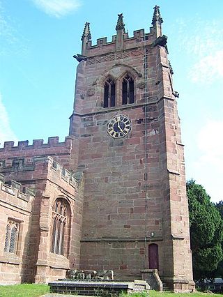
All Saints Church is in the village of Scholar Green in the parish of Odd Rode, Cheshire, England. It is an Anglican parish church in the deanery of Congleton, the archdeaconry of Macclesfield, and the diocese of Chester. The church is recorded in the National Heritage List for England as a designated Grade II* listed building.

