Rode Heath

Last updated

Rode Heath
Bibby Street, Rode Heath.jpg
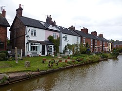
Cottages along the Trent and Mersey Canal
Cheshire UK location map.svg
Red pog.svg
Rode Heath
Location within Cheshire
Population2,150  [1]
OS grid reference SJ806573
Civil parish
Unitary authority
Ceremonial county
Region
Country England
Sovereign state United Kingdom
Post town Stoke-on-Trent
Postcode district ST7
Dialling code 01270
Police Cheshire
Fire Cheshire
Ambulance North West
UK Parliament
List of places
UK
England
Cheshire
53°06′47″N2°17′27″W / 53.112933°N 2.290755°W / 53.112933; -2.290755 Coordinates: 53°06′47″N2°17′27″W / 53.112933°N 2.290755°W / 53.112933; -2.290755

Rode Heath is a small village in the civil parish of Odd Rode, near Alsager and within the unitary authority of Cheshire East and the ceremonial county of Cheshire, England. [2] According to the 2001 census, Rode Heath had a population of 2,150. [1] In the 2011 census the figure had dropped to 2,019 and a 2016 estimate put the population at 1,943. [3] The village was previously two villages, Rode Heath and Thurlwood. Since extensive housing developments in Thurlwood the two are known simply as Rode Heath.

The Trent and Mersey Canal runs through Rode Heath. The village has two pubs, a primary school, post office, shop and takeaway. There are two churches: the Church of the Good Shepherd, one of the three churches that make up the Parish of Odd Rode, and the Rhema Mission Church (Rode Heath Chapel). [4] Close by is Rode Hall, the gardens of which are a tourist attraction. [5] The current owner of Rode Hall is Lady Wilbraham.

The village has a number of gentle walks along the canal and through the countryside, popular with dog walkers.

History

There was a salt works at Rode Heath run by James Sutton (1799–1868), who was also a canal boat carrier and High Sheriff of Derbyshire. In the past, Rode Heath and Thurlwood were separate settlements. From 1864 to 1962 there was a Primitive Methodist Chapel in Thurlwood. Many of the original inhabitants of Thurlwood were canal-boat families and some of the older houses, such as those in Faram's Road, had stables for the horses that towed the boats. Rode Heath and Thurlwood are now effectively joined, although the major 'link' and where you can see the end of one village lies on the southernmost lock.

Related Research Articles

Great Sankey Human settlement in England

Great Sankey is a civil parish and suburb of Warrington, Cheshire, England. It is 2 miles (3.2 km) west of Warrington town centre and has a population of 24,211.

Alsager Human settlement in England

Alsager is a town and civil parish in the unitary authority of Cheshire East and the ceremonial county of Cheshire, England, to the north-west of the city of Stoke-on-Trent, and east of the railway town of Crewe. The town has a population of 11,775. The civil parish is bordered by the parishes of Betchton to the north, Church Lawton to the north-east and east, Kidsgrove in Staffordshire to the south-east, Audley Rural, in Staffordshire to the south, Barthomley to the south-west, Haslington to the west, and Hassall to the north-west.

Congleton (borough) Borough in Cheshire (1974-2009)

Congleton was, from 1974 to 2009, a local government district with borough status in Cheshire, England. It included the towns of Congleton, Alsager, Middlewich and Sandbach. The headquarters of the borough council were located in Sandbach.

High Legh Human settlement in England

High Legh is a village, civil and ecclesiastical parish in the unitary authority of Cheshire East and the ceremonial county of Cheshire, England.

Betchton Human settlement in England

Betchton is a civil parish in the unitary authority of Cheshire East and the ceremonial county of Cheshire, England. According to the 2001 census it had a population of 620, increasing to 677 at the 2011 Census. The parish is immediately to the east of Sandbach, and includes Betchton Heath, Malkin's Bank and Hassall Green.

Broomhall, Cheshire Human settlement in England

Broomhall is a civil parish in the unitary authority of Cheshire East and the ceremonial county of Cheshire, England. The main line of the Shropshire Union Canal runs through the parish and the River Weaver forms part of its boundary. The main settlement is the hamlet of Broomhall Green, which lies on the A530 about 3.5 miles (5.6 km) south-west of Nantwich. The civil parish has an area of 539 hectares, and also includes part of the small settlement of Sandford, with a total population of around 200 in 2011. Nearby villages include Aston, Sound, Wrenbury and Audlem. Broomhall appears in the Domesday survey and the name was also historically spelled Bromhall.

Burland Human settlement in England

Burland is a village and civil parish in the unitary authority of Cheshire East and the ceremonial county of Cheshire, England, about 2½ miles west of Nantwich. The civil parish also includes the small settlements of Burland Lower Green, Burland Upper Green, Hollin Green and Stoneley Green, as well as parts of Gradeley Green and Swanley. The eastern part of the village of Ravensmoor also falls within the civil parish.

Toft, Cheshire Human settlement in England

Toft is a village and civil parish in the unitary authority of Cheshire East and the ceremonial county of Cheshire, England. It is located immediately to the south of Knutsford and is split by the A50 road to more southern Holmes Chapel. The village comprises several farms and a small picturesque church.

Wrenbury Human settlement in England

Wrenbury is a village in the civil parish of Wrenbury cum Frith, the unitary authority of Cheshire East, and the ceremonial county of Cheshire, England. It lies on the River Weaver, around 8.5 miles south-west of Crewe.

Henbury, Cheshire Human settlement in England

Henbury is a village and civil parish in the unitary authority of Cheshire East and the ceremonial county of Cheshire, England. According to the 2001 census, the entire civil parish had a population of 594. The village is 3.8 miles (6.1 km) west of Macclesfield on the A537.

Church Lawton Human settlement in England

Church Lawton is a small village and located in the unitary authority of Cheshire East and the ceremonial county of Cheshire in England. Its location is such that its eastern boundary forms part of the county boundary between Cheshire and Staffordshire and, because of its close proximity to Stoke-on-Trent, the parish has a Stoke postcode. In addition to ribbon development connecting Kidsgrove with Scholar Green, the parish also contains the hamlets of Lawton Gate, Lawton Heath and Lawton Heath End, and the Lawton Hall estate. According to the 2001 census, the population of the entire parish was 2,201.

Bradwall Human settlement in England

Bradwall is a small village and civil parish in the unitary authority of Cheshire East, about 2 mi (3.2 km) northwest of Sandbach in the ceremonial county of Cheshire, England, and about 20 mi (32 km) south of Manchester. According to the 2011 census, the population of the entire parish was 182. The area is predominantly agricultural, with no manufacturing or retail outlets.

Brereton, Cheshire Human settlement in England

Brereton is a civil parish in the unitary authority of Cheshire East and the ceremonial county of Cheshire, England. According to the 2001 census, the population of the entire civil parish was 1,012, increasing to 1,190 at the 2011 Census. Brereton is mentioned in the Domesday book as the Manor of Bretune. The civil parish includes the hamlets of Brereton Green, Brereton Heath, Smethwick Green, Medhurst Green, Sandlow Green and Davenport. It takes its name from Britonnic Bre meaning a hill and Reton meaning fern or ferns, thus Fernhill.

Odd Rode Human settlement in England

Odd Rode is a civil parish in the unitary authority of Cheshire East and the ceremonial county of Cheshire, England. It borders the Staffordshire parish of Kidsgrove, and includes the settlements of:

Worleston Human settlement in England

Worleston is a village and civil parish in the unitary authority of Cheshire East and the ceremonial county of Cheshire, England. The village lies 2½ miles north of Nantwich and 3 miles west of Crewe. The civil parish also includes the settlements of Beambridge, Rease Heath, Mile End and Rookery, with a total population of a little over 400, at the 2011 Census included Poole, Cheshire and measured 452.

Poole, Cheshire Village in Cheshire, England

Poole is a civil parish in the unitary authority of Cheshire East and the ceremonial county of Cheshire, England, which lies to the north west of Nantwich and to the west of Crewe. The Shropshire Union Canal runs through the parish. Nearby villages include Acton, Aston juxta Mondrum, Barbridge, Stoke Bank, Rease Heath and Worleston.

Moreton cum Alcumlow Human settlement in England

Moreton cum Alcumlow is a small civil parish in the unitary authority of Cheshire East and the ceremonial county of Cheshire, England. In the census of 2001 it was recorded as having a population of 150. The civil parish holds a parish council meeting under a grouping scheme with the adjacent civil parish of Newbold Astbury, and so it is consequently called Newbold Astbury-cum-Moreton Parish Council. Within the civil parish is the small village of Ackers Crossing, and Alcumlow Hall and Great Moreton Hall.

Somerford, Cheshire Human settlement in England

Somerford is a civil parish in the unitary authority of Cheshire East and the ceremonial county of Cheshire, England. It is adjacent to the north west of Congleton, from which town it has some housing overflow. According to the 2001 census, the population of the civil parish was 343, increasing to 430 at the 2011 Census.

Scholar Green Human settlement in England

Scholar Green is a village in the civil parish of Odd Rode, in Cheshire, England. Encompassing the smaller settlements of Kent Green and The Bank, it is near Mow Cop, Alsager, Rode Heath, Butt Lane and Kidsgrove and in the unitary authority area of Cheshire East.

All Saints Church, Scholar Green Church in Cheshire, England

All Saints Church is in the village of Scholar Green in the parish of Odd Rode, Cheshire, England. It is an active Anglican parish church in the deanery of Congleton, the archdeaconry of Macclesfield, and the diocese of Chester. The church is recorded in the National Heritage List for England as a designated Grade II* listed building.

References

  1. 1 2 2001 census data
  2. Parish of Odd Rode website. Retrieval Date: 10 August 2007.
  3. "Rode Heath (Cheshire East, North West England, United Kingdom) Population Statistics, Charts, Map, Location, Weather and Web Information". 26 October 2017. Archived from the original on 11 April 2018. Retrieved 11 April 2018.
  4. Rhema Mission website Retrieval Date: 17 March 2014.
  5. Rode Hall web site Retrieval Date: 19 November 2009.