Abbot's House of Combermere Abbey, a grade-I-listed former monastery
A total of 21 buildings and other structures in the English civil parish of Dodcott cum Wilkesley have been officially designated as listed buildings for their "special architectural and historic interest".[1] Dodcott cum Wilkesley is in the Cheshire East division of the ceremonial county of Cheshire, situated on the Cheshire Plain at the border with Shropshire. The civil parish is predominantly rural, with many scattered minor settlements, the largest of which is the small village of Burleydam. One of the listed buildings is classified by English Heritage as being in gradeI, meaning "of exceptional interest, sometimes considered to be internationally important" (this grade accounts for only 2.5% of all listed buildings);[1] two are in gradeII* and the remainder in gradeII.
Combermere Abbey, the remains of a former Cistercianmonastery founded in 1133, is listed at grade I.[2][3] Richly endowed at foundation, its lands included the manor of Wilkesley, the villages of Dodcott, Lodmore and Royal, land at Burleydam, and woods at Butterley Heyes.[4][5] After its dissolution in 1538, the abbey was granted to Sir George Cotton, who converted part of the abbey buildings into a country house, demolishing the remainder.[2][3][6] The estate remained in the Cotton family, later the Viscounts Combermere, until 1919.[7] Little remains of the medieval monastic buildings; remnants of medieval stonework from an arch are concealed in a cupboard in the house, and a sundial in the park is believed to incorporate part of a 12th-century column.[2][8] The existing house incorporates a building generally considered to represent the Abbot's House, part of whose timbers have recently been dated to around 1502. Its timber-framed structure was hidden under a Gothic remodelling of around 1814–21, in which cement render, castellations and windows with pointed arches were added.[2][3] Combermere Park occupies a substantial area in the west of the civil parish and contains almost half of the parish's listed buildings and structures.[9] The other listed buildings and structures within the park date from the 18th and 19th centuries; many also have Gothic features. Unusual structures include a grade-II*-listed game larder, an icehouse, a folly incorporating dog kennels, a battlementedwater tower and a clock tower.
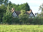
St Michael's Church and its gates and railings in Burleydam are also associated with the Cotton family. Three listed buildings are clustered in the small settlement of Royal's Green, two in the hamlet of Wilkesley, and others in the hamlets of Barnett Brook and Grindley Green.[9] The five half-timbered "black and white" cottages and farm buildings to have listed status all date from the 17th century; this century accounts for half of the timber-framed buildings in Cheshire.[10] The earliest is believed to be Butterley Heyes, an early 17th-century farmhouse which is one of the parish's grade-II*-listed buildings. The earliest brick building, Wilkesley Farmhouse, also dates from the 17th century, and brick predominates as a building material in the listed buildings dating from the 18th and 19th centuries. Several structures are built in sandstone, including Stone Lodge, an early 19th-century gate lodge to the abbey.
Combermere Abbey incorporates the remains of a Cistercianmonastery, founded in 1133. The monastic core is believed to represent the Abbot's House, a timber-framed building with a hammerbeam roof whose timbers have been dated to 1502; the building is thought to have been remodelled not long before the abbey's dissolution in 1538. It became the country house of the Cotton family, who redesigned it in 1563. The building was remodelled and extended in the 1790s, and further extended and Gothicised in around 1814–21, with the addition of cement render, castellations and windows with pointed arches. Parts of the later additions were removed or reduced in the 1970s.[2][3][11]
This farmhouse originally had an H-shaped plan with later extensions; its two projecting wings have gables. There are two storeys with attics under a tiled roof, with a prominent brick chimneystack to the right-hand end. The timber frame has been infilled with brick; it features small framing with angle braces.[12]
Game larder to the centre of the service court at Combermere Abbey
This octagonal red-brick game larder, probably by the Irish Morrison family, stands on a stone plinth, with a porch to the east face. The shallow-pitched slate roof has large overhangs, and is topped with an octagonal wooden lantern, also slate roofed. The faces each have a two-light window headed with a cusp-shaped arch. The original ironwork on which game was hung remains in the interior.[2][3][13]
This single-span road bridge carries Sheppenhall Lane over a tributary of the River Weaver. It is in red sandstone with a rounded arch and a projecting stone band which delineates the parapet from the arch.[14]
Now a folly, Brankelow Cottage was built as a model dairy by John Webb, and was used as a gamekeeper's cottage. Standing to the west of Comber Mere, the building is in red brick with stone dressings under a slate roof, to a cross-shaped plan; the main (lake-facing) front has seven symmetrical bays, a central three-bay projection and pavilions to each end, formerly used as kennels. It is ornamented with battlements, pinnacles, pilasters and arrowslits. The interior has a single elliptical room.[2][3][7][15][16]
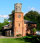
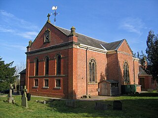
Now a parish church, St Michael's was built for Sir Lynch Cotton as a private chapel to Combermere Abbey, and extended at the east end in 1886. The church is in red brick with stone dressings under a slate roof. The windows have round arches. The three-bay west front, flanked by piers topped with fluted stone cylinders, has a clock with a carved stone surround in the gable. The northern porch has a carving depicting St George and the dragon.[17][18][19]
Gate piers and railings circa 5 yards to the north east of Stone Lodge
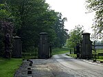
The gates and railings to the south-east entrance to Combermere Park stand adjacent to Stone Lodge and are also by the Irish Morrison family. The four gate piers are of yellow sandstone; the two central are taller and bear carved shields. At the date of listing (1986), the two central piers were surmounted with stone eagles, no longer present. The wrought-iron railings are set on a low sandstone wall.[15][20]
This former farmhouse has a timber frame with small framing, infilled in places with brick; at the date of listing (1979), some wattle and daub remained on the upper storey. There are brick chimneystacks to each side.[21]
Icehouse circa 100 yards from the stable block at Combermere Abbey
Formerly a pair of cottages, Lodmore Lane Cottages is now a single two-storey dwelling, restored and extended in the 20th century. The timber frame features small framing with brick infill.[23]
Northwoods Farmhouse is in red brick with three storeys and three bays under a tiled roof. The main entrance is placed asymmetrically, and has a 19th-century porch. Several of the ground- and first-floor windows have slightly arched heads.[25]
Outbuildings circa 10 yards to north of The Royals
This L-shaped farm outbuilding has a timber frame, infilled with brick, featuring small framing with passing braces, under a partly tiled roof. One wing has two storeys; the other is single storey.[26][27]
The cast-iron double gates and railings to St Michael's churchyard were moved from Lleweni Hall, Denbighshire. The gate piers are square in cross-section and are formed of open ironwork tracery. The railings are topped with arrowheads.[17][28]
The Royals is a T-shaped building with two storeys under a slate roof. It was formerly a hunting lodge. The timber frame features small framing with angle braces and rendered infill. The frame of the main part of the house has been heightened, while that of the rear wing remains at the original height. The front entrance is placed asymmetrically, and has a 19th-century porch.[27][29]
This red-brick farmhouse has three storeys and three bays to the main façade, under a tiled roof. The central entrance has a brick porch and the windows have stone sills. The left-hand face also has three narrow bays. The two prominent brick chimneystacks are placed symmetrically to each side.[30]
With the northern range, this forms a service court to the south-east of Combermere Abbey. It is constructed in red brick with a slate roof. The range includes a square clock tower, built in 1815 to celebrate the Battle of Waterloo; the clock is by JB Joyce & Co and has a circular clock face. The tower is decorated with arrowslits and capped by an octagonal timber bell cote whose openings have pointed arches.[3][15][31][32]
Designed by Edward Blore, the former stable block to Combermere Abbey, now divided into holiday cottages, forms a quadrangle surrounding a rectangular courtyard and incorporates two cottages and a former carriage house. The Elizabethan-style structure is in red brick with stone dressings under a slate roof, and features lancet windows, square lead-roofed turrets and an octagonal-flued chimneystack. The arched main entrance is placed asymmetrically in the front range; it is flanked by narrow octagonal turrets topped with spirelets.[2][3][15][33]
Wilkesley Farmhouse is a large two-storey building in red brick under a tiled roof. The earliest bay features blue-brick diaperwork. The farmhouse was substantially extended during the 19th century, with the addition of a T-shaped projecting wing.[35]
de Figueiredo P, Treuherz J. Cheshire Country Houses (Phillimore; 1988) ( ISBN0-85033-655-4)
Driver JT. Cheshire in the Later Middle Ages. A History of Cheshire, Vol. 6 (Series Editor: JJ Bagley), (Cheshire Community Council; 1971)
Hartwell C, Hyde M, Hubbard E, Pevsner N. The Buildings of England: Cheshire (2nd edn) (Yale University Press; 2011) ( ISBN978 0 300 17043 6)
Husain BMC. Cheshire under the Norman Earls: 1066–1237. A History of Cheshire, Vol. 4 (Series Editor: JJ Bagley) (Cheshire Community Council; 1973)
Local History Group, Latham FA (ed.). Wrenbury and Marbury (The Local History Group; 1999) ( ISBN0 9522284 5 9)
McKenna L. Timber Framed Buildings in Cheshire (Cheshire County Council; 1994) ( ISBN0-906765-16-1)
Related Research Articles
Baddiley is a scattered settlement and civil parish in the unitary authority of Cheshire East and the ceremonial county of Cheshire, England. The civil parish also includes the north-western part of the village of Ravensmoor, as well as the small settlements of Baddiley Hulse, Batterley Hill, and parts of Gradeley Green and Swanley. According to the 2001 Census the parish had a total population of 226, increasing at the 2011 Census to 249.
Marbury is a small village located at SJ560457 in the civil parish of Marbury cum Quoisley, within the unitary authority of Cheshire East and the ceremonial county of Cheshire, England. It is administered jointly with the adjacent civil parishes of Norbury and Wirswall. The village lies around 3 miles (5 km) north east of Whitchurch in Shropshire and 7 miles (11 km) south west of Nantwich in Cheshire. Nearby villages include Malpas, No Man's Heath, Norbury, Wirswall and Wrenbury. The civil parish borders Shropshire and covers 2,168 acres (877 ha); it also contains the small settlements of Hollins Lane, Marley Green and Quoisley, as well as parts of Hollyhurst and Willeymoor. The total population was just under 250 in 2001, and – combined with Wirswall – 352 in 2011.
Wrenbury-cum-Frith is a village and civil parish in the unitary authority of Cheshire East, and the ceremonial county of Cheshire, England. It lies on the River Weaver, around 8.5 miles south-west of Crewe.
Combermere Abbey is a former monastery, later a country house, near Burleydam, between Nantwich, Cheshire and Whitchurch in Shropshire, England, located within Cheshire and near the border with Shropshire. Initially Savigniac and later Cistercian, the abbey was founded in the 1130s by Hugh Malbank, Baron of Nantwich, and was also associated with Ranulf de Gernons, Earl of Chester. The abbey initially flourished, but by 1275 was sufficiently deeply in debt to be removed from the abbot's management. From that date until its dissolution in 1538, it was frequently in royal custody, and acquired a reputation for poor discipline and violent disputes with both lay people and other abbeys. It was the third largest monastic establishment in Cheshire, based on net income in 1535.
Dodcott cum Wilkesley is a civil parish in the unitary authority of Cheshire East and the ceremonial county of Cheshire, England. The hamlet of Wilkesley lies 2½ miles to the west of Audlem and 7 miles to the south west of Nantwich. The parish also includes the village of Burleydam, the largest settlement, as well as the small settlements of Butterley Heyes, Cheshire Fields, Combermere, Lightwood Green and Royal's Green. It also formerly contained the settlements of Pinsley Green and Smeaton Wood, now located in Wrenbury cum Frith civil parish. Nearby villages include Adderley and Calverhall in Shropshire and Audlem, Newhall and Wrenbury within Cheshire.
Barnett Brook is a hamlet in the Newhall and Dodcott cum Wilkesley civil parishes in the Cheshire East area of Cheshire, England. The hamlet is situated around a road bridge carrying Sheppenhall Lane across Barnett Brook, a tributary of the River Weaver. The sandstone bridge dates from the early to mid 19th century and is a grade II listed building.
St Margaret's Church overlooks the village green of Wrenbury, Cheshire, England. The church is recorded in the National Heritage List for England as a designated Grade II* listed building. It is an active Anglican parish church in the diocese of Chester, the archdeaconry of Macclesfield and the deanery of Nantwich. Its benefice is combined with those of St Michael's, Baddiley and St Mary's and St Michael's, Burleydam.
St Mary's and St Michael's Church is in the village of Burleydam in the civil parish of Dodcott cum Wilkesley, Cheshire, England. The church is some 1.5 miles (2 km) to the southeast of Combermere Abbey. It is recorded in the National Heritage List for England as a designated Grade II listed building. It is an active Anglican parish church in the diocese of Chester, the archdeaconry of Macclesfield and the deanery of Nantwich. Its benefice is combined with those of St Michael, Baddiley, and St Margaret, Wrenbury.
Acton was an ancient parish in the Nantwich Hundred of Cheshire, England.
Fourteen buildings and other structures in the English civil parish of Wrenbury cum Frith have been officially designated as listed buildings for their "special architectural and historic interest". Three of the listed buildings are classified as being in grade II* and the remainder in grade II; the parish has no grade-I-listed buildings.
Sutton Weaver is a civil parish in Cheshire West and Chester, England. It is largely rural, and contains the village of Sutton Weaver. The parish is traversed in a north–south direction by the M56 motorway, the A56 road, and the Chester to Manchester Line, and from east to west by the River Weaver and the Weaver Navigation, and the A533 road. It contains twelve buildings that are recorded in the National Heritage List for England as designated listed buildings. Of these one is listed at Grade I, another at Grade II*, and the other ten at Grade II. The structures include houses, farm buildings, and bridges. Most of them are houses or farm buildings, but there is also a bridge and two viaducts.
Burleydam is a small English village in the civil parish of Dodcott cum Wilkesley in the unitary authority of Cheshire East and the ceremonial county of Cheshire, near the border with Shropshire. It is on the A525. The nearest town is Whitchurch in Shropshire, around 8 km (5 miles) to the west; nearby small settlements include Barnett Brook, Grindley Green and Royal's Green in Dodcott cum Wilkesley; Dodd's Green and Newhall in Newhall civil parish; and Old Woodhouses and New Woodhouses in Shropshire.
Ashton Hayes is a former civil parish, now in the parish of Ashton Hayes and Horton-cum-Peel, in Cheshire West and Chester, England. It contains six buildings that are recorded in the National Heritage List for England as designated listed buildings. Other than the village of Ashton Hayes, the parish is rural. One of the buildings is listed at Grade II*, a farmhouse, and the others at Grade II; the latter consist of the village church and hall, a cottage, and a farm building.
There are over 20,000 Grade II* listed buildings in England. This page is a list of these buildings in the unitary authority of Cheshire East.
Audlem is a civil parish in Cheshire East, England. It contains 25 buildings that are recorded in the National Heritage List for England as designated listed buildings. Of these, two are listed at Grade I, the highest grade, one is listed at Grade II*, the middle grade, and the others are at Grade II. The major settlement in the parish is the village of Audlem. In the village the listed buildings include churches and cemetery chapels, a former grammar school, a hotel, houses, and a memorial lamp standard. In the surrounding countryside the listed buildings include country houses, farmhouses, farm buildings, and a road bridge. Running through the parish is the Shropshire Union Canal, and the listed structures associated with this are bridges, mileposts and a lock keeper's cottage.
Bunbury is a civil parish in Cheshire East, England. It contains 31 buildings that are recorded in the National Heritage List for England as designated listed buildings. Of these, one is listed at Grade I, the highest grade, one is listed at Grade II*, the middle grade, and the others are at Grade II. The parish contains the settlements of Bunbury, Bunbury Heath, and Lower Bunbury, with surrounding countryside. Many of the listed buildings are houses, cottages, farmhouses and farm buildings, some dating back to the 17th century and timber-framed. The other buildings are a church and associated structures, a public house, a former school, an active school, and a watermill.
Marbury cum Quoisley is a civil parish in Cheshire East, England. It contains 11 buildings that are recorded in the National Heritage List for England as designated listed buildings. Of these, one is listed at Grade II*, the middle grade, and the others are at Grade II. Apart from the village of Marbury the parish is rural. The major buildings in the parish are St Michael's Church and Marbury Hall; these and some associated buildings are listed. Also listed are some 16th and 17th-century houses and farm buildings that are timber-framed or incorporate timber framing. The parish includes the part of the Combermere estate that contains a monumental obelisk that is listed.
Newhall is a civil parish in Cheshire East, England. It contains 14 buildings that are recorded in the National Heritage List for England as designated listed buildings, all of which are at Grade II. This grade is the lowest of the three gradings given to listed buildings and is applied to "buildings of national importance and special interest". The parish contains the village of Aston, but is otherwise almost completely rural, and its listed buildings reflect this, including farmhouses and other houses. The Shropshire Union Canal runs through the parish, and there are two listed buildings associated with this, a bridge and a milepost. Also listed are a boundary stone, a telephone kiosk, and a lychgate.
Brankelow Cottage, also known as Brankelow Folly and Brankelow House, is a folly on the Combermere Abbey estate, in Cheshire, England. It is listed at grade II. Dating from 1797, it was originally a model dairy and later a gamekeeper's cottage with attached kennels. Described by Nikolaus Pevsner and co-authors as a "charming eyecatcher," the folly is ornamented with battlements, pinnacles, pilasters, arrowslits and fancy brickwork.
Simonstone is a civil parish in Ribble Valley, Lancashire, England. It contains 22 listed buildings that are recorded in the National Heritage List for England. All of the listed buildings are designated at Grade II, the lowest of the three grades, which is applied to "buildings of national importance and special interest". The parish contains the village of Simonstone and surrounding countryside. The listed buildings are almost all houses and associated structures, or farmhouses and farm buildings, the others being a milestone and a former toll house.
This page is based on this Wikipedia article Text is available under the CC BY-SA 4.0 license; additional terms may apply. Images, videos and audio are available under their respective licenses.