
Disley is a village and civil parish in Cheshire, England. It is located on the edge of the Peak District in the Goyt valley, south of Stockport and close to the county boundary with Derbyshire at New Mills. The population at the 2011 Census was 4,294. To the north, the River Goyt and the Peak Forest Canal, which opened in 1800, pass along the edge of the village. Today, it is a dormitory village retaining a semi-rural character.

Heanor (/ˈhiːnə/) is a town in the Amber Valley district of Derbyshire, England. It lies 8 miles (13 km) north-east of Derby and forms, with the adjacent village of Loscoe, the civil parish and town council-administered area of Heanor and Loscoe, which had a population of 17,251 in the 2011 census.
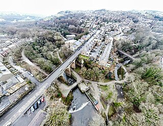
New Mills is a town in the Borough of High Peak, Derbyshire, England, 8 miles (13 km) south-east of Stockport and 13 miles (21 km) from Manchester at the confluence of the River Goyt and Sett. It is close to the border with Cheshire and above the Torrs, a 70 feet (21 m) deep gorge cut through carboniferous sandstone, on the north-western edge of the Peak District National Park.

Whaley Bridge is a town and civil parish in the High Peak district of Derbyshire, England. It is situated on the River Goyt, 16 miles (26 km) south-east of Manchester, 7 miles (11 km) north of Buxton, 9 miles (14 km) north-east of Macclesfield and 28 miles (45 km) west of Sheffield. It had a population of 6,455 at the 2011 census, including Furness Vale, Horwich End, Bridgemont, Fernilee, Stoneheads and Taxal.

Cockerton is an area in the north-west of Darlington in the borough of Darlington, County Durham, England. The Cocker Beck flows through the area and empties into the River Skerne via The Denes, an area and string of valleyed parks donated for the town in the early 20th century. It is also near Mowden, Branksome, West Park and Faverdale.

Dronfield Woodhouse is a district of Dronfield, in the North East Derbyshire district, in the county of Derbyshire, England. The area has been inhabited since at least the 11th century and its main road, Carr Lane, features a 13th-century house, formerly Hall Farm. The 19th-century former primary school on Holmesfield Road is now an elderly care home.
Blakenhall is a small village and former civil parish, now in the parish of Doddington and District, in the unitary authority area of Cheshire East and the ceremonial county of Cheshire, England, about 7 miles (11 km) south-east of Nantwich. It lies on the county boundary with Staffordshire. The parish has an area of 654 hectares and also includes the small settlements of The Den and Gonsley Green, with a total population of 125 in 2001. Nearby villages include Wybunbury in Cheshire and Betley and Wrinehill in Staffordshire. Blakenhall was first recorded in the Domesday survey as Blachenhale, and the parish had one of Cheshire's early ironworks in the 17th and 18th centuries. The area is rural and predominantly agricultural, with small areas of ancient woodland and the nature reserve of Blakenhall Moss, a rejuvenating lowland raised bog. The Crewe-to-Stafford railway line runs through the parish and it is on the proposed route of HS2.

Broomhall is a civil parish in the unitary authority of Cheshire East and the ceremonial county of Cheshire, England. The main line of the Shropshire Union Canal runs through the parish and the River Weaver forms part of its boundary. The main settlement is the hamlet of Broomhall Green, which lies on the A530 about 3.5 miles (5.6 km) south-west of Nantwich. The civil parish has an area of 539 hectares, and also includes part of the small settlement of Sandford, with a total population of around 200 in 2011. Nearby villages include Aston, Sound, Wrenbury and Audlem. Broomhall appears in the Domesday survey and the name was also historically spelled Bromhall.

Bulkeley is a village and former civil parish, now in the parish of Bulkeley and Ridley, in the unitary authority area of Cheshire East and the ceremonial county of Cheshire, England. The village is on the A534 road, 9 miles (14 km) west of Nantwich. In the 2011 census it had a population of 239.

Boulton is a suburb and former local government ward of the city of Derby, in the ceremonial county of Derbyshire, England, and is located about four miles to the south-east of Derby city centre. It is closely associated with Alvaston and comes under the "Alvaston" postal dependent locality and code sector, and the Alvaston South ward. Alvaston South is represented on Derby City Council by three councillors.

Wirswall is a village and former civil parish, now in the parish of Marbury and District, in the unitary authority area of Cheshire East and the ceremonial county of Cheshire, England, located at SJ544441 near the Shropshire border, around 1½ miles north of Whitchurch. The historical township had an area of 973 acres (3.94 km2). The civil parish also included the settlements of Bradeley Green, Wicksted and part of Willey Moor.

Kettleshulme is a village and former civil parish, now in the parish of Kettleshulme and Lyme Handley, in the Cheshire East district, in the ceremonial county of Cheshire, England. The village is close to the border with Derbyshire, on the B5470 road from Whaley Bridge to Macclesfield in the valley of the Todd Brook, a tributary of the River Goyt. In 2001 the parish had a population of 353.

Wildboarclough is a village in the civil parish of Macclesfield Forest and Wildboarclough, in the Cheshire East district, in the ceremonial county of Cheshire, England, within the Peak District National Park. Bilsborough states that the name arises from the rapid rise in levels of the Clough Brook after a heavy fall of rain, but Mills gives it as a deep valley frequented by wild boar. According to old legend it was the place where the last wild boar in England was killed.

Coal Aston is a village in the civil parish of Dronfield, in the North East Derbyshire district, in the county of Derbyshire, England. It is by the town of Dronfield.
Puddington is a village and civil parish on the Wirral Peninsula, in the unitary authority of Cheshire West and Chester and the ceremonial county of Cheshire, England. It is located to the south east of the town of Neston and close to the border with Wales.

Lyme Handley, sometimes known as Lyme, is a former civil parish, now in the parish of Kettleshulme and Lyme Handley, in between Disley and Stockport, in the unitary authority area of Cheshire East and the ceremonial county of Cheshire, England. According to the 2001 census, it had a population of 151.

Burbage is a village in the High Peak district, in the county of Derbyshire, England. At the 2011 Census Burbage was a ward of the High Peak Borough Council. The population taken at this Census was 2,540.

Hunsterson is a hamlet and former civil parish, now in the parish of Doddington and District, in the unitary authority area of Cheshire East and the ceremonial county of Cheshire, England. The hamlet is located 2¾ miles to the north east of Audlem and 6 miles to the south of Crewe. The parish also included the settlements of Brown Moss, Four Lane End, Foxes Bank and Whittaker's Green. In 2011 the parish had a population of 163. Nearby villages include Audlem, Buerton, Hatherton and Hankelow.

Fairfield is a district of Buxton, in the High Peak of Derbyshire, England. The historic medieval village of Fairfield was centred around a village green.

The Borough of Warrington is a unitary authority area with borough status in the ceremonial county of Cheshire, England. The borough is centred around the town of Warrington, and extends out into outlying villages of Lymm and Great Sankey and the town of Birchwood.

