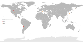
A supervolcano is a volcano that has had an eruption with a volcanic explosivity index (VEI) of 8, the largest recorded value on the index. This means the volume of deposits for such an eruption is greater than 1,000 cubic kilometers.
Plinian eruptions or Vesuvian eruptions are volcanic eruptions marked by their similarity to the eruption of Mount Vesuvius in 79 AD, which destroyed the ancient Roman cities of Herculaneum and Pompeii. The eruption was described in a letter written by Pliny the Younger, after the death of his uncle Pliny the Elder.

Mount Takahe is a 3,460-metre-high (11,350 ft) snow-covered shield volcano in Marie Byrd Land, Antarctica, 200 kilometres (120 mi) from the Amundsen Sea. It is a c. 30-kilometre-wide (19 mi) mountain with parasitic vents and a caldera up to 8 kilometres (5 mi) wide. Most of the volcano is formed by trachytic lava flows, but hyaloclastite is also found. Snow, ice, and glaciers cover most of Mount Takahe. With a volume of 780 km3 (200 cu mi), it is a massive volcano; the parts of the edifice that are buried underneath the West Antarctic Ice Sheet are probably even larger. It is part of the West Antarctic Rift System along with 18 other known volcanoes.

Lascar is a stratovolcano in Chile within the Central Volcanic Zone of the Andes, a volcanic arc that spans Peru, Bolivia, Argentina and Chile. It is the most active volcano in the region, with records of eruptions going back to 1848. It is composed of two separate cones with several summit craters. The westernmost crater of the eastern cone is presently active. Volcanic activity is characterized by constant release of volcanic gas and occasional vulcanian eruptions.
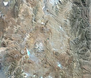
Cerro Galán is a caldera in the Catamarca Province of Argentina. It is one of the largest exposed calderas in the world and forms part of the Central Volcanic Zone of the Andes, one of the three volcanic belts found in South America. One of several major caldera systems in the Central Volcanic Zone, the mountain is grouped into the Altiplano–Puna volcanic complex.
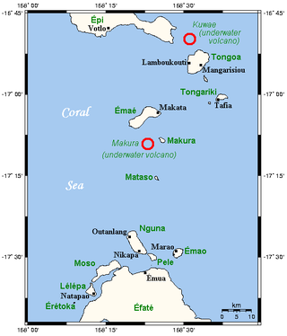
Kuwae was a landmass that existed in the vicinity of Tongoa and was destroyed by volcanic eruption in fifteenth century, probably through caldera subsidence. The exact location of the caldera is debated. A submarine caldera, now known as Kuwae caldera that is located between the Epi and Tongoa islands, is a potential candidate. Kuwae caldera cuts through the flank of the Tavani Ruru volcano on Epi and the northwestern end of Tongoa. Another potential candidate is a proposed caldera between Tongoa and Tongariki.
Phreatomagmatic eruptions are volcanic eruptions resulting from interaction between magma and water. They differ from exclusively magmatic eruptions and phreatic eruptions. Unlike phreatic eruptions, the products of phreatomagmatic eruptions contain juvenile (magmatic) clasts. It is common for a large explosive eruption to have magmatic and phreatomagmatic components.

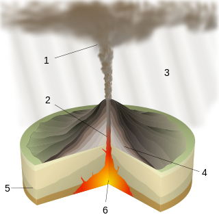
Volcanic ash consists of fragments of rock, mineral crystals, and volcanic glass, produced during volcanic eruptions and measuring less than 2 mm (0.079 inches) in diameter. The term volcanic ash is also often loosely used to refer to all explosive eruption products, including particles larger than 2 mm. Volcanic ash is formed during explosive volcanic eruptions when dissolved gases in magma expand and escape violently into the atmosphere. The force of the gases shatters the magma and propels it into the atmosphere where it solidifies into fragments of volcanic rock and glass. Ash is also produced when magma comes into contact with water during phreatomagmatic eruptions, causing the water to explosively flash to steam leading to shattering of magma. Once in the air, ash is transported by wind up to thousands of kilometres away.
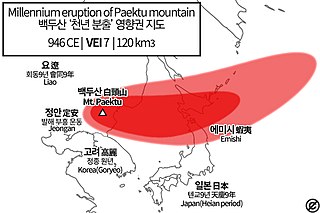
Paektu Mountain, also known as Changbaishan, on the border of the Democratic People's Republic of Korea and China erupted in late 946 CE. This event is known as the Millennium Eruption or Tianchi eruption. It is one of the most powerful volcanic eruptions in recorded history and is classified as a Magnitude 6.5-7 eruption.

The Campanian Ignimbrite eruption was a major volcanic eruption in the Mediterranean during the late Quaternary, classified 7 on the Volcanic Explosivity Index (VEI). The event has been attributed to the Archiflegreo volcano, the 12-by-15-kilometre-wide caldera of the Phlegraean Fields, located 20 km (12 mi) west of Mount Vesuvius under the western outskirts of the city of Naples and the Gulf of Pozzuoli, Italy. It is the largest explosive volcanic event in Europe in the past 200,000 years, and the largest eruption of Campi Fleigrei caldera.

Littoral cones are a form of volcanic cone. They form from the interaction between lava flows and water. Steam explosions fragment the lava and the fragments can pile up and form a cone. Such cones usually form on ʻaʻā lava flows, and typically are formed only by large lava flows. They have been found on Hawaii and elsewhere.

Ciomadul is a dormant volcano in Romania. It is in the Eastern Carpathians, between the spa towns of Băile Tușnad and Balvanyos. Ciomadul lies at the southeastern end of the Carpathian volcanic chain and it is the youngest volcano of the Carpatho-Pannonian region. Ciomadul consists of several lava domes with two embedded explosion craters known as Mohoș and Sfânta Ana, the latter of which contains a crater lake, Lake Sfânta Ana. The dominant volcanic rock at Ciomadul is potassium-rich dacite.

Mount Erciyes, also known as Argaeus, its etymon, is an inactive volcano in Kayseri Province, Turkey. It is a large stratovolcano surrounded by many monogenetic vents and lava domes, and one maar. The bulk of the volcano is formed by lava flows of andesitic and dacitic composition. At some time in the past, part of the summit collapsed towards the east.

Costanza Bonadonna is an Italian earth scientist who is a Full Professor of volcanology and geological risk at the University of Geneva. In 2020, she was named President-Elect of volcanology, geochemistry, and petrology at the American Geophysical Union (AGU).

The Whakamaru Caldera was created in a massive supereruption 335,000 years ago and is approximately 30 by 40 km in size and is located in the North Island of New Zealand. It now contains active geothermal areas as well as the later Maroa Caldera.
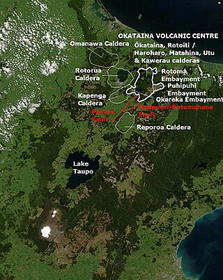
Ōkataina Caldera is a volcanic caldera and its associated volcanoes located in Taupō Volcanic Zone of New Zealand's North Island. It has several actual or postulated sub calderas. The Ōkataina Caldera is just east of the smaller separate Rotorua Caldera and southwest of the much smaller Rotomā Embayment which is usually regarded as an associated volcano. It shows high rates of explosive rhyolitic volcanism although its last eruption was basaltic. The postulated Haroharo Caldera contained within it has sometimes been described in almost interchangeable terms with the Ōkataina Caldera or volcanic complex or centre and by other authors as a separate complex defined by gravitational and magnetic features.. Since 2010 other terms such as the Haroharo vent alignment, Utu Caldera, Matahina Caldera, Rotoiti Caldera and a postulated Kawerau Caldera are often used, rather than a Haroharo Caldera classification.
The Ōkāreka Embayment is a volcanic feature in Taupo Volcanic Zone of New Zealand. Its most significant recent volcanic eruption was about 15,700 years ago and this deposited the widespread Rotorua tephra that reached beyond Auckland.

The Cascade Volcanic Arc is a chain of volcanoes stretching from southern British Columbia down to northern California. Within the arc there is a variety of stratovolcanoes like Mount Rainier and broad shield volcanoes like Medicine Lake. But calderas are very rare in the Cascades, with very few forming over the 39 million year lifespan of the arc.

Hudson Volcano is a volcano in the rugged mountains of southern Chile. Lying in the Southern Volcanic Zone of the Andes, it was formed by the subduction of the oceanic Nazca Plate under the continental South American Plate. The Nazca Plate ends there at the Chile Triple Junction; south of Hudson is a smaller volcano, followed by a long gap without active volcanoes that separates the Southern Volcanic Zone from the Austral Volcanic Zone. Hudson has the form of a 10-kilometre-wide (6-mile) volcanic caldera filled with ice. The Huemules Glacier emerges from the northwestern side of the caldera. The volcano has erupted rocks ranging from basalt to rhyolite, but large parts of the caldera are formed by non-volcanic rocks.


