Dispersed settlement

Last updated
Dispersed settlement or Streusiedlung in Brulisau, Appenzell Innerrhoden, Switzerland Picswiss AI-04-02.jpg
Dispersed settlement or Streusiedlung in Brülisau, Appenzell Innerrhoden, Switzerland

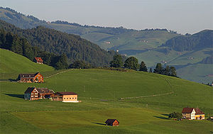
A dispersed settlement, also known as a scattered settlement, is one of the main types of settlement patterns used by landscape historians to classify rural settlements found in England and other parts of the world. Typically, there are a number of separate farmsteads scattered throughout the area. [1] A dispersed settlement contrasts with a nucleated village. It can be known as main human settlements.

Contents

The French term bocage is sometimes used to describe the type of landscape found where dispersed settlements are common.

In addition to Western Europe, dispersed patterns of settlement are found in parts of Papua New Guinea, as among the Gainj, Ankave, and Baining tribes. It is also frequently met with in nomadic pastoral societies. In Ghana, Kumbyili in the northern region is also an example of a dispersed settlement

England

In England, dispersed settlements are often found in the areas of ancient enclosure outside the central region—for example, Essex, Kent and the West Country. [2] An example of a dispersed settlement given by W G Hoskins is Middle Barton in Steeple Barton, Oxfordshire. [3]

In some parts of England, the pattern of dispersed settlement has remained unchanged for many hundreds of years. Many of the locations found in Domesday may be dispersed farmsteads. [4] It is sometimes possible to identify documentary references to farmsteads in the 18th and 19th centuries with these Domesday entries. [5]

In areas of Kent and Essex close to London, the development of residential housing during the 20th century has often disguised the dispersed nature of the original settlement.

The farmsteads which make up the dispersed settlement are often surrounded by small irregularly shaped fields. Traditionally, trees are encouraged to grow at the edges of these fields and in thin strips alongside roads. However, during the 20th century, much of this woodland disappeared, either as a result of disease or modern farming practice. Arthur Young's description of the view from Langdon Hills, "dark lanes intersected with numberless hedges and woods," [6] is a typical description of the landscape in an area of dispersed settlements.

Italy

Anthony Galt has written an extensive study of the dispersed settlement pattern around Locorotondo in the Province of Bari in southern Italy. [7] [8] In this case, the settlement pattern developed because of movement from the town to the countryside in the 19th century. Emphyteutic leases were used by landowners seeking to increase their income from land that was only marginally attractive for agriculture by encouraging the creation of vineyards.

German-speaking Europe

Known as Streusiedlungen (singular Streusiedlung), dispersed settlements are a characteristic of various parts of German-speaking Europe, including in areas of Westphalia, historically the Ruhr urban area (the dispersed settlements lending themselves to the development of urban sprawl after industrialisation), the Austro-Bavarian parts of the Alps (Upper Bavaria, Austria, South Tyrol) as well as Alamannic parts of the Alps (Bernese Oberland, Central Switzerland).

Notes

  1. Richard Muir, The NEW Reading the Landscape, University of Exeter Press
  2. Roberts & Rathmell, An Atlas of Rural Settlement in England, English Heritage
  3. The Making of the English Landscape. However, he uses the term "fragmented village".
  4. Keith Challis, Settlement Morphology and Medieval Planning Archived October 6, 2011, at the Wayback Machine
  5. W G Hoskins, Fieldwork in Local History
  6. Arthur Young, A Six Weeks' Tour through the Southern Counties of England and Wales
  7. Anthony Galt, Far from the Church Bells (CUP, 1991)
  8. D. Curtis, https://www.academia.edu/1933250/Is_there_an_agro-town_model_for_Southern_Italy_Exploring_the_diverse_roots_and_development_of_the_agro-town_structure_through_a_comparative_case_study_in_Apulia

Related Research Articles

<span class="mw-page-title-main">Kingdom of Essex</span> Former kingdom on the island of Britain (527–825 CE)

The Kingdom of the East Saxons, referred to as the Kingdom of Essex, was one of the seven traditional kingdoms of the Anglo-Saxon Heptarchy. It was founded in the 6th century and covered the territory later occupied by the counties of Essex, Middlesex, much of Hertfordshire and west Kent. The last king of Essex was Sigered of Essex and in 825, he ceded the kingdom to Ecgberht, King of Wessex.

<span class="mw-page-title-main">East Anglia</span> Region of England

East Anglia is an area in the East of England, often defined as including the counties of Norfolk, Suffolk and Cambridgeshire. The name derives from the Anglo-Saxon kingdom of the East Angles, a people whose name originated in Anglia, in what is now northern Germany.

<span class="mw-page-title-main">Historic counties of England</span> Category of areas of England

The historic counties of England are areas that were established for administration by the Normans, in many cases based on earlier kingdoms and shires created by the Angles, Saxons, Jutes, Celts and others. They are alternatively known as ancient counties, traditional counties, former counties or simply as counties. In the centuries that followed their establishment, as well as their administrative function, the counties also helped define local culture and identity. This role continued even after the counties ceased to be used for administration after the creation of administrative counties in 1889, which were themselves amended by further local government reforms in the years following.

<span class="mw-page-title-main">Weald</span> Area of South East England

The Weald is an area of South East England between the parallel chalk escarpments of the North and the South Downs. It crosses the counties of Hampshire, Surrey, Sussex and Kent. It has three separate parts: the sandstone "High Weald" in the centre; the clay "Low Weald" periphery; and the Greensand Ridge, which stretches around the north and west of the Weald and includes its highest points. The Weald once was covered with forest, and its name, Old English in origin, signifies "woodland". The term is still used today, as scattered farms and villages sometimes refer to the Weald in their names.

<span class="mw-page-title-main">Anglo-Saxon architecture</span> Period of architecture in England from the mid-5th century until 1066

Anglo-Saxon architecture was a period in the history of architecture in England from the mid-5th century until the Norman Conquest of 1066. Anglo-Saxon secular buildings in Britain were generally simple, constructed mainly using timber with thatch for roofing. No universally accepted example survives above ground. Generally preferring not to settle within the old Roman cities, the Anglo-Saxons built small towns near their centres of agriculture, at fords in rivers or sited to serve as ports. In each town, a main hall was in the centre, provided with a central hearth.

<span class="mw-page-title-main">New Milton</span> Human settlement in England

New Milton is a market town in southwest Hampshire, England. To the north is in the New Forest and to the south the coast at Barton-on-Sea. The town is equidistant between Lymington and Christchurch, 6 miles (10 km) away.

<span class="mw-page-title-main">Bonnington</span> Human settlement in England

Bonnington is a dispersed village and civil parish on the northern edge of the Romney Marsh in Ashford District of Kent, England. The village is located eight miles (13 km) to the south of the town of Ashford on the B2067.

<span class="mw-page-title-main">Alpheton</span> Human settlement in England

Alpheton is a village and civil parish in the Babergh district of Suffolk, England. Located on the A134 road about six miles north of Sudbury, in 2005 it had a population of 260, reducing to 256 at the 2011 Census. According to Eilert Ekwall the meaning of the village name is the homestead of Aelfled.

<span class="mw-page-title-main">Cliffe Woods</span> Human settlement in England

Cliffe Woods is a small estate on the Hoo Peninsula in the unitary authority of Medway in South East England. It was, until 1998, part of Kent and is still ceremonially associated via the Lieutenancies Act. It forms part of the parish of Cliffe and Cliffe Woods.

<span class="mw-page-title-main">Wigmore, Herefordshire</span> Village in Herefordshire, England

Wigmore is a village and civil parish in the northwest part of the county of Herefordshire, England. It is located on the A4110 road, about 8 miles (13 km) west of the town of Ludlow, in the Welsh Marches. In earlier times, it was also an administrative district, called a hundred.

<span class="mw-page-title-main">Locorotondo</span> Comune in Apulia, Italy

Locorotondo is a town and municipality of the Metropolitan City of Bari, Apulia, southern Italy, with a population of about 14,000. It is situated between Martina Franca and Alberobello in the Valle d'Itria, a green stretch of countryside dotted with the famous whitewashed cone-roofed trulli houses. Locorotondo is listed as one of the most beautiful villages in Italy and it has been awarded the Orange Flag of the Touring Club of Italy due to the harmony of its shapes and the accessibility of the old town, as it can be easily visited on foot. It is an intricate network of little streets lined with old buildings and it is known for its typical houses called "Le Cummerse", which have a regular geometric shape and a sloping roof made of two different layers of limestone slabs. These dwellings have nowadays been renovated and offered to visitors in the form of scattered hotels.

<span class="mw-page-title-main">Chadwell St Mary</span> Human settlement in England

Chadwell St Mary is an area of the unitary authority of Thurrock in Essex, England. It is one of the traditional parishes in Thurrock and a former civil parish. Its residential areas are on the higher ground overlooking the former Thameside marshland. Grays is a town centred 2 miles (3.2 km) west of it. Closer still, 1 mile (1.6 km) south is the modern town of Tilbury which was almost wholly part of the parish until the end of the 19th century. The settlement is frequently referred to simply as Chadwell, particularly before the 19th century.

Bradwell or Bradwell Juxta Coggeshall is a village and civil parish in Essex, England. It is located on the River Blackwater, approximately 5 km (3.1 mi) east of Braintree and is 19 km (12 mi) north-northeast from the county town of Chelmsford. The village is in the district and parliamentary constituency of Braintree. The parish is part of the Blackwater parish cluster.

A nucleated village, or clustered settlement, is one of the main types of settlement pattern. It is one of the terms used by geographers and landscape historians to classify settlements. It is most accurate with regard to planned settlements: its concept is one in which the houses, even most farmhouses within the entire associated area of land, such as a parish, cluster around a central church, which is close to the village green. Other focal points can be substituted depending on cultures and location, such as a commercial square, circus, crescent, a railway station, park or a sports stadium.

Landscape history is the study of the way in which humanity has changed the physical appearance of the environment – both present and past. It is sometimes referred to as landscape archaeology. It was first recognised as a separate area of study during the 20th century and uses evidence and approaches from other disciplines including archaeology, architecture, ecology, aerial photography, rephotography, local history and historical geography.

The study of field systems in landscape history is concerned with the size, shape and orientation of a number of fields. These are often adjacent, but may be separated by a later feature.

<span class="mw-page-title-main">Lawshall</span> Human settlement in England

Lawshall is a village and civil parish in Suffolk, England. Located around a mile off the A134 between Bury St Edmunds and Sudbury, it is part of Babergh district. The parish has nine settlements comprising the three main settlements of The Street, Lambs Lane and Bury Road along with the six small hamlets of Audley End, Hanningfield Green, Harrow Green, Hart's Green, Hibb's Green and Lawshall Green.

<i>The Making of the English Landscape</i> Book about history of Englands landscapes by William George Hoskins

The Making of the English Landscape is a 1954 book by the English local historian William George Hoskins. The book is also the introductory volume in a series of the same name which deals with the English Landscape county by county.

Regiones or provinciae,(singular: provincia), also referred to by historians as small shires or early folk territories, were early territorial divisions of Anglo-Saxon England, referred to in sources such as Anglo-Saxon charters and the writings of Bede. They are likely to have originated in the years before 600, and most evidence for them occurs in sources from or about the 7th century.