Related Research Articles

The Lower Mainland is a geographic and cultural region of the mainland coast of British Columbia that generally comprises the regional districts of Metro Vancouver and the Fraser Valley. Home to approximately 3.05 million people as of the 2021 Canadian census, the Lower Mainland contains sixteen of the province's 30 most populous municipalities and approximately 60% of the province's total population.
The Fraser Valley is a geographical region in southwestern British Columbia, Canada and northwestern Washington State. It starts just west of Hope in a narrow valley encompassing the Fraser River and ends at the Pacific Ocean stretching from the North Shore Mountains, opposite the city of Vancouver BC, to just south of Bellingham, Washington.

Abbotsford is a city in British Columbia next to the Canada–United States border, Greater Vancouver and the Fraser River. With a census population of 153,569 people (2021), it is the largest municipality in the province outside metropolitan Vancouver. Abbotsford–Mission has the third-highest proportion of visible minorities among census metropolitan areas in Canada, after the Greater Toronto Area and the Greater Vancouver CMA. It is home to Tradex, the University of the Fraser Valley, and Abbotsford International Airport.
Highway 11, known locally as the Abbotsford–Mission Highway, is a 17 km (11 mi) long at-grade expressway that figuratively cuts the Fraser Valley in half. The highway was first given the '11' designation in 1958, and it originally followed South Fraser Way through Abbotsford, being re-routed onto the four-lane Sumas Way in the mid-1980s. Highway 11 originally entered Mission over the same bridge that carries a spur of the Canadian Pacific Railway across the Fraser River, but it was re-routed onto its own bridge, the Mission Bridge, in 1973.
The Cheam Indian Band is a First Nations band government of the Stó:lō people in the Upper Fraser Valley region of British Columbia, Canada, located near the community of Rosedale. They traditionally speak the Upriver dialect of Halkomelem, one of the Salishan family of languages. The name Cheam means "wild strawberry place" and is the namesake of Mount Cheam, which overlooks the community and most of the Upper Fraser Valley. They are a member government of the Sto:lo Tribal Council, one of two Sto:lo tribal councils.

Sumas Lake(Halq’eméyle: Semá:th Lake, Nooksack: Semáts Xácho7, ) was a shallow freshwater lake surrounded by extensive wetlands that once existed in eastern Fraser Lowland, located on the south side of the Sumas River between the foothills of Sumas Mountain and Vedder Mountain. It disappeared after being artificially drained for flood control and land reclamation from 1920 to 1924, leaving behind a low-lying flatland known as the Sumas Prairie, which is nowadays drained by the Saar Creek and the namesaked Sumas Drainage Canal.
The Sto꞉lo Nation Chiefs Council is a First Nations Tribal Council in the Fraser Valley region of the Canadian province of British Columbia that is the tribal council for First Nations band governments in the area of Chilliwack, Abbotsford and at Nicomen Island. This tribal council should not be confused with the Stó:lō Tribal Council, which is composed of different bands of the Stó:lō people. Many Sto:lo communities and their governments are not in either tribal council.
Clearbrook is a neighbourhood of the City of Abbotsford, British Columbia, located in the western portion of the city in the vicinity of Clearbrook Road. The area was originally known as Sandy Flats or West Abbotsford, and was located in the Poplar district of the District of Matsqui. It became known as Clearbrook by the late 1940s, most likely named after Clearbrook Road, a road that originally ran from Old Yale Road south across the Canada-USA border to nearby Clearbrook, Washington.
Huntingdon is a community within Abbotsford, British Columbia, Canada. It is located immediately north of the Canada–US border, and is the location of the Sumas–Huntingdon Border Crossing. The main road through the community is Highway 11. The name of the community is also the present name of the border crossing connecting to Sumas, Washington.
Mount Lehman or Mt. Lehman is a small rural community located in the Fraser Valley of south western British Columbia, Canada. The community was established in 1874 and became part of the District of Matsqui in 1892. The District of Matsqui was incorporated into the present day City of Abbotsford, British Columbia in 1995.
Sumas Mountain, also referred to as Canadian Sumas to distinguish it from an identically named mountain just 10 km (6.2 mi) to the south in U.S. state of Washington across the border, is a mountain in eastern Fraser Lowland, in the Lower Mainland region of the Canadian province of British Columbia. It sits on the south bank of the Fraser River, west of the smaller Chilliwack Mountain across the Vedder River mouth, and serves as a geographic landmark dividing the Fraser Valley into "Upper" and "Lower" sections. Sumas Peak is an official name for the summit located on the south shore of the Fraser River in the Fraser Valley between Abbotsford and Chilliwack, British Columbia. Elevation 910 m (2,986 ft) above sea level, prominence 875 m (2,871 ft).
Sumas is a city in Washington.
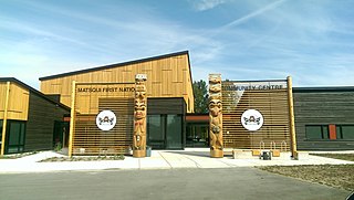
The Matsqui First Nation is the band government of the Matsqui people, a Sto:lo Aboriginal group located in the Central Fraser Valley region, at Matsqui, in the northern part of Abbotsford, British Columbia, Canada. They are a member government of the Sto:lo Nation tribal council.
The Sumas First NationSumalh or Sumas Indian Band is a band government of the Sto:lo people located in the Upper Fraser Valley region, at the community of Kilgard a.k.a. Upper Sumas, part of Abbotsford, British Columbia, Canada. They are a member government of the Sto:lo Nation tribal council.
The Soowahlie First Nation, or Soowahlie Band, is a band government of the Sto:lo people located in the Upper Fraser Valley region at Cultus Lake, British Columbia, Canada. They are a member government of the Stó:lō Tribal Council. The Reserve land area currently comprises 533.4 hectares and has a population of 373.
The Leq'á:mel First Nation, formerly known as Lakahahmen First Nation, is a First Nations band government whose community and offices are located in the area near Deroche, British Columbia in the Fraser Valley region in Canada, about 12 kilometres east of the District of Mission. They are a member government of the Sto:lo Nation Chiefs Council, which is one of two tribal councils of the Sto:lo.
The Central Fraser Valley Regional District was a regional district in the province of British Columbia, Canada, located in the Lower Mainland region, south of the Fraser River and west of Chilliwack. It comprised the Township and City of Langley, the Village of Abbotsford, and the Districts of Matsqui and Sumas, plus adjoining unincorporated areas.
Sumas was a district municipality in the Fraser Valley region of British Columbia, Canada, located between the then-Village of Abbotsford (W) and Chilliwack (E). It was amalgamated with the Village of Abbotsford in 1972 into the District of Abbotsford.
Sumas Prairie is a landform in British Columbia, Canada and the State of Washington, United States. Part of the Fraser Lowland, it was created by the draining of Sumas Lake early in the 20th Century, and extends from the Vedder Canal southwestwards into northern Whatcom County, Washington. The British Columbia Highway 1 traverses the former lakebed on the prairie between Abbotsford and Chilliwack.
The Matsqui people are a Sto:lo Aboriginal group located in the Central Fraser Valley region of British Columbia, Canada. Their band government is the Matsqui First Nation, a member of the Sto:lo Nation tribal council. The core traditional territory of the Matsqui stretches along the Fraser River from Crescent Island to Sumas Mountain, and southward beyond the Canada-United States border. Today the band administers four reserves and has a population of 225. Their original language is Halq'eméylem.
References
- "Matsqui (District Municipality)". BC Geographical Names .
- "Matsqui (Urban Community)". BC Geographical Names .
- "Matsqui" entry in the Canadian Encyclopedia
- ↑ "Matsqui (railway point)". BC Geographical Names .
- ↑ Galloway, Brent. (2009) Dictionary of Upriver Halkomelem. https://escholarship.org/content/qt65r158r4/qt65r158r4.pdf
- ↑ "Matsqui Island". BC Geographical Names .
- ↑ "Matsqui Prairie". BC Geographical Names .
- ↑ "District of Matsqui". Canadian Heraldic Authority. Retrieved 1 September 2024.