 |
|---|
| Constitution |
Suriname is divided into 10 districts (Dutch : districten).
| |
|---|
| Constitution |
Suriname is divided into 10 districts (Dutch : districten).

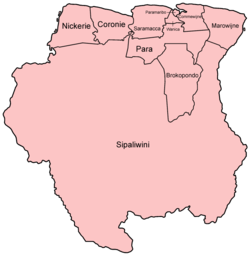
| District | Capital | Area (km2) | Area (%) | Population (2012 census) [1] | Population (%) | Pop. dens. (inhabitants/km2) | |
|---|---|---|---|---|---|---|---|
| Suriname | Paramaribo | 163,820 | 100.0 | 541,638 | 100.0 | 3.3 | |
| 1 | Brokopondo | Brokopondo | 7,364 | 4.5 | 15,909 | 2.9 | 2.2 |
| 2 | Commewijne | Nieuw-Amsterdam | 2,353 | 1.4 | 31,420 | 5.8 | 13.4 |
| 3 | Coronie | Totness | 3,902 | 2.2 | 3,391 | 0.6 | 0.9 |
| 4 | Marowijne | Albina | 4,627 | 2.8 | 18,294 | 3.4 | 4.0 |
| 5 | Nickerie | Nieuw-Nickerie | 5,353 | 3.3 | 34,233 | 6.3 | 6.4 |
| 6 | Para | Onverwacht | 5,393 | 3.3 | 24,700 | 4.6 | 4.6 |
| 7 | Paramaribo | Paramaribo | 182 | 0.1 | 240,924 | 44.5 | 1323.8 |
| 8 | Saramacca | Groningen | 3,636 | 2.2 | 17,480 | 3.2 | 4.8 |
| 9 | Sipaliwini | none | 130,567 | 79.7 | 37,065 | 6.8 | 0.3 |
| 10 | Wanica | Lelydorp | 443 | 0.3 | 118,222 | 21.8 | 266.9 |
The country was first divided up into subdivisions by the Dutch on October 8, 1834, when a Royal Decree declared that there were to be 8 divisions and 2 districts: [2]
The divisions were areas near the capital city, Paramaribo, and the districts were areas further away from the city.
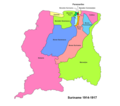


In 1927, Suriname's districts were revised, and the country was divided into 7 districts. In 1943, 1948, 1949, 1952 and 1959 further small modifications were made. In 1968 the districts were redrawn again, into [3]
These divisions remained until 1980, when yet again, the borders of the districts were redrawn, however, with the following requirements:
The last changes to the districts were in 1985. [3]

Politics of Suriname take place in a framework of a representative democratic assembly-independent republic, whereby the president of Suriname is the head of state and head of government, and of a pluriform multi-party system. Executive power is exercised by the government. The executive power is dependent on the Parliament in theory. Legislative power is vested in both the government and the National Assembly. The judiciary is independent of the executive and the legislature.

Coronie is a district of Suriname, situated on the coast. Coronie's capital city is Totness. The district border the Atlantic Ocean to the north, the Surinamese district of Saramacca to the east, the Surinamese district of Sipaliwini to the south and the Surinamese district of Nickerie to the west. The district is served by the Totness Airstrip.

Nickerie is a district of Suriname, on the north-west coast. Nickerie's capital city is Nieuw-Nickerie. Another town is Wageningen. The district borders the Atlantic Ocean to the north, the Surinamese district of Coronie to the east, the Surinamese district of Sipaliwini to the south and the region of East Berbice-Corentyne in Guyana to the west.

Saramacca is a district of Suriname, in the north. Saramacca's capital city is Groningen, with other towns and cities including Batavia, Kampong Baroe, Uitkijk, Maho and Boskamp. Saramacca has a population of 17,480 and an area of 3,636 km2.

Sipaliwini is the largest district of Suriname, located in the south. Sipaliwini is the only district that does not have a regional capital, as it is directly administered by the national government in Paramaribo. Sipaliwini District includes disputed areas, with the southwestern region controlled and administered by Guyana, whereas the southeastern region is controlled by French Guiana.

Brotherhood and Unity in Politics is a political party in Suriname founded on 29 April 1973.

Groningen is the capital town of the Saramacca District, Suriname.

Nieuw Amsterdam is the capital of the Commewijne District in Suriname. It is a small coastal town situated at the confluence of the Suriname River and Commewijne River, just across from Paramaribo, the country's capital. Its population at the 2012 census was 5,650, with around 1,200 people living in the main town, most of whom are of Javanese and East Indian origin. It is the location of the historical Fort Nieuw-Amsterdam, today an open-air museum. The town of Mariënburg with former sugarcane factory is located 3 km from Nieuw Amsterdam and part of the resort.

The Suriname River is 480 kilometres (300 mi) long and flows through the country of Suriname. Its sources are located in the Guiana Highlands on the border between the Wilhelmina Mountains and the Eilerts de Haan Mountains. The source of the Upper Suriname River is at the confluence of the Gran Rio and Pikin Rio near the village of Goddo. The river continues shortly after the reservoir along Brokopondo as the Lower Suriname River. Than it flows Berg en Dal, the migrant communities Klaaskreek and Nieuw-Lombé, Jodensavanne, Carolina, Ornamibo and Domburg, before reaching the capital Paramaribo on the left bank and Meerzorg on the right bank. At Nieuw-Amsterdam it is joined by the Commewijne and immediately thereafter at the sandspit Braamspunt it flows into the Atlantic Ocean.

The Coppename is a river in Suriname in the district of Sipaliwini, forming part of the boundary between the districts of Coronie and Saramacca.
The ten districts of Suriname are divided into 63 resorts. Within the capital city of Paramaribo, a resort entails a neighbourhood; in other cases it is more akin to a municipality, consisting of a central place with a few settlements around it. The resorts in the Sipaliwini District are especially large, since the interior of Suriname is sparsely inhabited.

The following outline is provided as an overview of and topical guide to Suriname:

Saramacca Polder is a resort in Suriname, located in the Wanica District. Its population at the 2012 census was 10,217. And the majority of the population is of East Indian descent. The Saramacca Polder was created between 1894 and 1904. The main function was agriculture. The Commissaris Weytinghweg was built in 1906, and connects the polder with Paramaribo. Initially the area was mainly used for rice cultivation, but has become home to companies and suburban housing.
The (northern) East-West Link is a road in Suriname between Albina in the eastern part of the country to Nieuw Nickerie in the western part, via the capital city of Paramaribo. The southern East-West Link connects Paramaribo with Apoera via Bitagron. Construction of the road link started in the 1960s.
General elections were held in Surinam on 30 May 1949. The result was a victory for the National Party of Suriname, which won 13 of the 21 seats. Voter turnout was 47.5%.
The district Suriname is a former district of the country Suriname. The capital of this district was Paramaribo, though this city was located in the district Paramaribo.

Johannes François Adriaan Cateau van Rosevelt was a Dutch navy officer and civil servant in Suriname where he was, among other things, agent-general for immigration and a member of the Colonial Estates of Suriname. He is known for his map of Suriname.

The 2022 Suriname floods beginning in March have affected Indigenous and Maroon settlement areas in the eastern part of Suriname. The floods were caused by the La Niña weather phenomenon, which replaced the short dry season in 2022.
| Brokopondo District |  | |
|---|---|---|
| Commewijne District | ||
| Coronie District | ||
| Marowijne District | ||
| Nickerie District | ||
| Para District | ||
| Paramaribo District | ||
| Saramacca District | ||
| Sipaliwini District | ||
| Wanica District | ||
| | This Suriname location article is a stub. You can help Wikipedia by expanding it. |
