Division of Murray

Last updated

Murray
Australian House of Representatives Division
Division of MURRAY 2016.png
Division of Murray in Victoria, as of the 2016 federal election
Created1949
Abolished2019
Namesake Murray River
Electors 104,359 (2016)
Area16,229 km2 (6,266.1 sq mi)
DemographicRural

The Division of Murray was an Australian Electoral Division in the state of Victoria. It was located in the north of the state, adjoining the Murray River, which forms Victoria's border with New South Wales. It included the towns of Shepparton, Echuca, Cobram, Yarrawonga, Boort and Bridgewater. In 2018 the division was renamed the Division of Nicholls, coming into effect at the 2019 federal election.

Contents

History

The Murray River, the division's namesake MurrayBridgeMurrayRiver.JPG
The Murray River, the division's namesake

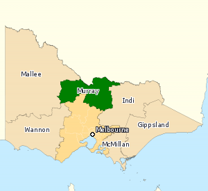
The Division was proclaimed at the redistribution of 11 May 1949, and was first contested at the 1949 election. It was named after the Murray River, which itself was named after British Secretary of State for War and the Colonies Sir George Murray. It was first held by John McEwen, who briefly served as Prime Minister after the disappearance of Harold Holt, and subsequently became the inaugural Deputy Prime Minister under John Gorton. His successor in the seat, Bruce Lloyd, went on to serve as deputy leader to three successive Nationals leaders - Ian Sinclair, Charles Blunt and Tim Fischer.

Murray was in the hands of either the Liberal or National parties for its entire existence. At the time of its abolition, it was the third-safest coalition-held seat in Australia, with a 20-point swing required for Labor to win it.

In 2018 the division was renamed the Division of Nicholls, coming into effect at the 2019 federal election.

Members

ImageMemberPartyTermNotes
  Sir John McEwen.jpg John McEwen
(1900–1980)
Country 10 December 1949
1 February 1971
Previously held the Division of Indi. Served as minister under Menzies, Holt and Gorton. Served as Prime Minister from 1967 to 1968. Served as Deputy Prime Minister under Gorton. Resigned to retire from politics
  Bruce Lloyd 1971.jpg Bruce Lloyd
(1937–)
20 March 1971
2 May 1975
Retired
  National Country 2 May 1975 –
16 October 1982
  Nationals 16 October 1982 –
29 January 1996
  Sharman Stone.jpg Sharman Stone
(1951–)
Liberal 2 March 1996
9 May 2016
Served as minister under Howard. Retired
  Aus LNP MPs Bangkok (cropped Drum).jpg Damian Drum
(1960–)
Nationals 2 July 2016
11 April 2019
Previously a member of the Victorian Legislative Council. Transferred to the Division of Nicholls after Murray was abolished in 2019

Election results

2016 Australian federal election: Murray [1]
PartyCandidateVotes%±%
National Damian Drum 31,10535.34+35.34
Liberal Duncan McGauchie28,19432.03−29.38
Labor Alan Williams13,18814.98−5.76
Greens Ian Christoe3,8804.41+0.48
Country Robert Danieli3,5564.04+4.04
Independent Fern Summer3,3233.78+3.78
Independent Andrew Bock1,4671.67+1.67
Rise Up Australia Yasmin Gunasekera1,1951.36+0.73
Independent Diane Teasdale1,0371.18+1.18
Independent Nigel Hicks8440.96+0.96
Citizens Electoral Council Jeff Davy2270.26−0.10
Total formal votes88,01691.16−2.51
Informal votes8,5308.84+2.51
Turnout 96,54692.51−2.04
Two-candidate-preferred result
National Damian Drum 48,52755.13+55.13
Liberal Duncan McGauchie39,48944.87−26.00
National gain from Liberal Swing N/A

Related Research Articles

<span class="mw-page-title-main">Division of Higgins</span> Australian federal electoral division

The Division of Higgins is an Australian Electoral Division in Victoria for the Australian House of Representatives. The division covers 41 km2 (16 sq mi) in Melbourne's inner south-eastern suburbs. The main suburbs include Armadale, Ashburton, Carnegie, Glen Iris, Kooyong, Malvern, Malvern East, Murrumbeena, Prahran and Toorak; along with parts of Camberwell, Ormond and South Yarra. Though historically a safe conservative seat, Higgins was won by the Liberal Party by a margin of just 3.9 percent over the Labor Party at the 2019 election, the closest result in the seat’s history. It then flipped to Labor in the 2022 election.

<span class="mw-page-title-main">Coalition (Australia)</span> Group of centre-right political parties in Australia

The Liberal–National Coalition, commonly known simply as the Coalition or the LNP, is an alliance of centre-right to right-wing political parties that forms one of the two major groupings in Australian federal politics. The two partners in the Coalition are the Liberal Party of Australia and the National Party of Australia. Its main opponent is the Australian Labor Party (ALP); the two forces are often regarded as operating in a two-party system. The Coalition was last in government from 2013 to 2022. The group is led by Peter Dutton, who succeeded Scott Morrison after the 2022 federal election.

<span class="mw-page-title-main">Division of Cook</span> Australian federal electoral division

The Division of Cook is an Australian electoral division in the State of New South Wales.

<span class="mw-page-title-main">Division of Bendigo</span> Australian federal electoral division

The Division of Bendigo is an Australian electoral division in the state of Victoria. The division was proclaimed in 1900, and was one of the original 65 divisions to be contested at the first federal election. It is named for the city of Bendigo.

<span class="mw-page-title-main">Division of Corio</span> Australian federal electoral division

The Division of Corio is an Australian electoral division in the state of Victoria. The division was proclaimed in 1900, and was one of the original 65 divisions to be contested at the first federal election. Named for Corio Bay, it has always been based on the city of Geelong, although in the past it stretched as far east as the outer western suburbs of Melbourne.

<span class="mw-page-title-main">Division of Flinders</span> Australian federal electoral division

The Division of Flinders is an Australian Electoral Division in Victoria. The division is one of the original 65 divisions contested at the first federal election. It is named after Matthew Flinders, the first man to circumnavigate Australia, and the person credited with giving Australia its name.

<span class="mw-page-title-main">Damian Drum</span> Australian politician

Damian Kevin Drum is an Australian politician who has represented Murray and Nicholls in the Australian House of Representatives since the 2016 federal election as a member of The Nationals. Drum served as the Assistant Minister to the Deputy Prime Minister in the Second Turnbull Ministry between 20 December 2017 and 5 March 2018.

<span class="mw-page-title-main">Division of Curtin</span> Australian federal electoral division

The Division of Curtin is an Australian electoral division in Western Australia.

The Division of Gwydir was an Australian electoral division in the state of New South Wales. The division was proclaimed in 1900, and was one of the original 65 divisions to be contested at the first federal election. As a result of the electoral redistribution of 13 September 2006, Gwydir was abolished and ceased to exist at the 2007 federal election.

<span class="mw-page-title-main">Division of Gorton</span> Australian federal electoral division

The Division of Gorton is an Australian Electoral Division in the state of Victoria.

<span class="mw-page-title-main">Division of Wills</span> Australian federal electoral division

The Division of Wills is an Australian electoral division of Victoria. It is currently represented by Peter Khalil of the Australian Labor Party.

<span class="mw-page-title-main">Division of Indi</span> Australian federal electoral division

The Division of Indi ( "IN-dye") is an Australian electoral division in the state of Victoria. The division is located in the north-east of the state, adjoining the border with New South Wales. The largest settlements in the division are the regional cities of Wodonga, Wangaratta, and Benalla. Other towns in the electorate include Rutherglen, Mansfield, Beechworth, Myrtleford, Bright, Alexandra, Tallangatta, Corryong and a number of other small villages. While Indi is one of the largest electorates in Victoria, much of it is located within the largely uninhabited Australian Alps. While Wodonga serves as a regional hub for much of the more heavily populated northern part of the electorate, the southern part is closer to Melbourne than Wodonga.

The Division of Yarra was an Australian electoral division in the state of Victoria. It was located in inner eastern suburban Melbourne, and was named after the Yarra River, which originally formed the eastern border of the Division, and eventually ran through it. It originally covered the suburbs of Abbotsford, Collingwood, Richmond and part of Fitzroy. By the time it was abolished in 1969, it no longer covered Abbotsford or Fitzroy, but included Burnley and Hawthorn.

<span class="mw-page-title-main">Division of Menzies</span> Australian federal electoral division

The Division of Menzies is an Australian Electoral Division in the state of Victoria.

<span class="mw-page-title-main">Division of Maribyrnong</span> Australian federal electoral division

The Division of Maribyrnong is an Australian electoral division in the state of Victoria. It is located in the inner north-western suburbs of Melbourne. Suburbs include Aberfeldie, Airport West, Avondale Heights, Essendon, Footscray, Gowanbrae, Keilor East, Maribyrnong, Moonee Ponds, Niddrie, West Footscray and Tullamarine. Due to redistributions, the division has been slowly moving west and changed with the introduction of the Division of Fraser in 2018. According to the 2011 census, Maribyrnong has the highest proportion of Catholics in any Commonwealth Electoral Division in Australia with 41.6% of the population.

<span class="mw-page-title-main">Division of Lalor</span> Australian federal electoral division

The Division of Lalor is an Australian Electoral Division in the state of Victoria. Located in the south-western suburbs of Melbourne, it includes the south-western hub of Werribee as well as the suburbs of Hoppers Crossing, Tarneit, Truganina, Wyndham Vale and part of Point Cook.

<span class="mw-page-title-main">Division of Mallee</span> Australian federal electoral division

The Division of Mallee is an Australian Electoral Division in the state of Victoria. It is located in the far north-west of the state, adjoining the border with South Australia in the west, and the Murray River in the north. At 81,962 square kilometres (31,646 sq mi), it is the largest Division in Victoria. It includes the centres of Mildura, Ouyen, Swan Hill, St Arnaud, Warracknabeal, Stawell, Horsham and Maryborough.

In Australia, a redistribution is the process of redrawing the boundaries of electoral divisions for the House of Representatives arising from changes in population and changes in the number of representatives. There is no redistribution for the Senate as each State constitutes a division, though with multiple members. The Australian Electoral Commission (AEC), an independent statutory authority, oversees the apportionment and redistribution process for federal divisions, taking into account a number of factors. Politicians, political parties and the public may make submissions to the AEC on proposed new boundaries, but any interference with their deliberations is considered a serious offence.

<span class="mw-page-title-main">Division of Melbourne Ports</span> Former Australian federal electoral division

The Division of Melbourne Ports was an Australian federal electoral division in the inner south-eastern suburbs of Melbourne, Victoria, Australia. It was located to the south of Melbourne's central business district and covered an area of approximately 40 km2 around the north and north-eastern shores of Port Phillip Bay.

<span class="mw-page-title-main">Division of Nicholls</span> Australian federal electoral division

The Division of Nicholls is an Australian Electoral Division in the state of Victoria, which was contested for the first time at the 2019 federal election.

References

  1. Murray, VIC, Virtual Tally Room 2016, Australian Electoral Commission.

36°16′44″S144°38′46″E / 36.279°S 144.646°E / -36.279; 144.646