Dixon, Montana

Last updated

Dixon, Montana
CDP
Wikipix.jpg
View of Dixon from nearby hillside
Sanders County Montana Incorporated and Unincorporated areas Dixon Highlighted.svg
Location of Dixon, Montana
Coordinates: 47°18′42″N114°20′28″W / 47.31167°N 114.34111°W / 47.31167; -114.34111
Country United States
State Montana
County Sanders
Area
[1]
  Total6.90 sq mi (17.88 km2)
  Land6.63 sq mi (17.16 km2)
  Water0.28 sq mi (0.72 km2)
Elevation
[2]
2,523 ft (769 m)
Population
 (2020)
  Total221
  Density33.35/sq mi (12.88/km2)
Time zone UTC-7 (Mountain (MST))
  Summer (DST) UTC-6 (MDT)
ZIP code
59831
Area code 406
FIPS code 30-20950
GNIS feature ID0770675 [2]

Dixon is a census-designated place (CDP) in Sanders County, Montana, United States. The population was 221 at the 2020 census.

Contents

The town is named for Joseph M. Dixon, a Montana politician. [3] The town sits adjacent to the lower Flathead River near the CSKT Bison Range. [3]

Geography

According to the United States Census Bureau, the CDP has a total area of 6.9 square miles (18 km2), of which 6.6 square miles (17 km2) is land and 0.3 square miles (0.78 km2) (4.35%) is water.

Demographics

Historical population
CensusPop.Note
2020 221
U.S. Decennial Census [4]

At the 2000 census, [5] there were 216 people, 89 households and 54 families residing in the CDP. The population density was 32.5 inhabitants per square mile (12.5/km2). There were 93 housing units at an average density of 14.0 per square mile (5.4/km2). The racial makeup of the CDP was 75.46% White, 20.37% Native American, and 4.17% from two or more races. Hispanic or Latino of any race were 1.39% of the population.

There were 89 households, of which 29.2% had children under the age of 18 living with them, 46.1% were married couples living together, 7.9% had a female householder with no husband present, and 39.3% were non-families. 31.5% of all households were made up of individuals, and 15.7% had someone living alone who was 65 years of age or older. The average household size was 2.43 and the average family size was 3.07.

25.9% of the population were under the age of 18, 7.4% from 18 to 24, 20.4% from 25 to 44, 27.8% from 45 to 64, and 18.5% who were 65 years of age or older. The median age was 42 years. For every 100 females, there were 94.6 males. For every 100 females age 18 and over, there were 102.5 males.

The median household income was $15,455 and the family median income was $23,750. Males had a median income of $28,750 and females $16,250. The per capita income was $11,379. About 19.6% of families and 35.9% of the population were below the poverty line, including 45.5% of those under the age of eighteen and 22.2% of those 65 or over.

According to the most recent demographics data available from the Census Bureau released in December 2018, Figure 1 Dixon illustrates it has 203 population. [6]

Of the 203 people living in Dixon, Montana, 95 are Men and 108 are Women, with the median age being 44. The total number of occupied homes in Dixon is 83, with 53 of them being Family led homes. [7]

Media

The Sanders County Ledger is a local newspaper. [8] It is printed weekly and also available online.

Related Research Articles

<span class="mw-page-title-main">St. Xavier, Montana</span> Unincorporated community and census-designated place in Montana, United States

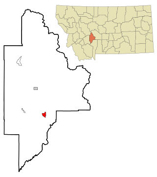
St. Xavier is an unincorporated community and census-designated place (CDP) in Big Horn County, Montana, United States. The CDP population was 83 at the 2010 census.

<span class="mw-page-title-main">Radersburg, Montana</span> Village in Montana, United States

Radersburg is an unincorporated rural village in Broadwater County, Montana, United States.

<span class="mw-page-title-main">Toston, Montana</span> Census-designated place in Montana, United States

Toston is a census-designated place (CDP) in Broadwater County, Montana, United States. The population was 108 at the 2010 census.

<span class="mw-page-title-main">Winston, Montana</span> Census-designated place in Montana, United States

Winston is a census-designated place (CDP) in Broadwater County, Montana, United States. The population was 147 at the 2010 census.

<span class="mw-page-title-main">Black Eagle, Montana</span> CDP in Montana, United States

Black Eagle is a census-designated place (CDP) in Cascade County, Montana, United States. The population was 904 at the 2010 census. It is a suburb of Great Falls.

<span class="mw-page-title-main">Fort Shaw, Montana</span> CDP in Montana, United States

Fort Shaw is a census-designated place (CDP) in Cascade County, Montana, United States. The population was 280 at the 2010 census. Named for a former United States military outpost, it is part of the Great Falls, Montana Metropolitan Statistical Area.

<span class="mw-page-title-main">Sun Prairie, Montana</span> CDP in Montana, United States

Sun Prairie is a census-designated place (CDP) in Cascade County, Montana, United States. The population was 1,630 at the 2010 census. It is part of the Great Falls Metropolitan Statistical Area and may have evolved as a remote suburb of Great Falls.

<span class="mw-page-title-main">Ulm, Montana</span> CDP in Montana, United States

Ulm is a census-designated place (CDP) in Cascade County, Montana, United States. It was originally a large ranch owned by Indiana-born cattleman William Ulm. The population was 738 at the 2010 census. It is part of the Great Falls, Montana Metropolitan Statistical Area. The Zip Code is 59485.

<span class="mw-page-title-main">North Browning, Montana</span> Census-designated place in Montana, United States

North Browning is a census-designated place (CDP) in Glacier County, Montana, United States. The population was 2,408 at the 2010 census.

<span class="mw-page-title-main">South Browning, Montana</span> Census-designated place in Montana, United States

South Browning is a census-designated place (CDP) in Glacier County, Montana, United States. The population was 1,785 at the 2010 census. South Browning is a rural village on the Blackfeet Indian Reservation. It is bordered to the north by the town of Browning.

<span class="mw-page-title-main">Starr School, Montana</span> Census-designated place in Montana, United States

Starr School is a census-designated place (CDP) in Glacier County, Montana, United States. The population was 252 at the 2010 census.

<span class="mw-page-title-main">Ravalli, Montana</span> Place in Montana, United States

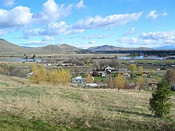
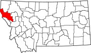
Ravalli is an unincorporated community in Lake County, Montana, United States. The population was 76 at the 2010 census, down from 119 in 2000. For statistical purposes, the United States Census Bureau has defined Ravalli as a census-designated place (CDP). In the early 1900s, the Pablo-Allard herd in Ravalli was said to be the largest collection of the bison remaining in the U.S. and played a critical role in the conservation of bison.

<span class="mw-page-title-main">Heron, Montana</span> CDP in Montana, United States

Heron is a census-designated place (CDP) in Sanders County, Montana, named for the village of Heron which is located within it. The population of the CDP was 173 at the 2020 census.

<span class="mw-page-title-main">Lonepine, Montana</span> CDP in Montana, United States

Lonepine is a census-designated place (CDP) in Sanders County, Montana, United States. The population was 137 at the 2000 census.

<span class="mw-page-title-main">Noxon, Montana</span> CDP in Montana, United States

Noxon is a census-designated place (CDP) in Sanders County, Montana, United States. The population of the whole CDP was 255 at the 2020 census.

<span class="mw-page-title-main">Old Agency, Montana</span> CDP in Montana, United States

Old Agency is a census-designated place (CDP) in Sanders County, Montana, United States. The population was 95 at the 2000 census.

<span class="mw-page-title-main">Paradise, Montana</span> CDP in Montana, United States

Paradise is a census-designated place (CDP) in Sanders County, Montana, United States. The population was 166 at the 2020 census.

<span class="mw-page-title-main">North Corbin, Kentucky</span> Census-designated place in Kentucky, United States

North Corbin is a census-designated place (CDP) in Laurel and Knox counties in the U.S. state of Kentucky. The population was 1,727 at the 2020 census down from 1,773 at the 2010 census. The census bureau also lists the Laurel County portion of North Corbin as a CCD with a population of 10,729.

<span class="mw-page-title-main">Parker School, Montana</span> Census-designated place in Montana, United States

Parker School is a census-designated place (CDP) in Hill and Chouteau counties in the U.S. state of Montana. The population was 340 at the 2010 census.

<span class="mw-page-title-main">Niarada, Montana</span> Unincorporated community in Montana, United States

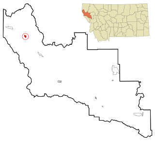
Niarada is a census-designated place (CDP) in Flathead and Sanders counties in Montana, United States. The population was 27 at the 2010 census, down from 50 in 2000.

References

  1. "ArcGIS REST Services Directory". United States Census Bureau. Retrieved September 5, 2022.
  2. 1 2 U.S. Geological Survey Geographic Names Information System: Dixon, Montana
  3. 1 2 "Dixon". Montana Place Names Companion. Montana Historical Society. Retrieved April 2, 2021.
  4. "Census of Population and Housing". Census.gov. Retrieved June 4, 2016.
  5. "U.S. Census website". United States Census Bureau . Retrieved January 31, 2008.
  6. "Dixon CDP Montana Demographics data population census".
  7. "Current Dixon, Montana Population, Demographics and stats in 2020, 2019".
  8. "About". Sanders County Ledger. Retrieved January 3, 2024.