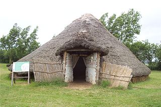
Flag Fen, east of Peterborough, England, is a Bronze Age site developed about 3500 years ago, consisting of more than 60,000 timbers arranged in five very long rows, creating a wooden causeway across the wet fenland. Part-way across the structure a small island was formed. Items associated with it have led scholars to conclude that the island was of religious significance. Archaeological work began in 1982 at the site, which is located 800 m east of Fengate. Flag Fen is now part of the Greater Fens Museum Partnership. A visitor centre has been constructed on site and some areas have been reconstructed, including a typical Iron Age roundhouse dwelling.

Avebury is a Neolithic henge monument containing three stone circles, around the village of Avebury in Wiltshire, in southwest England. One of the best known prehistoric sites in Britain, it contains the largest megalithic stone circle in the world. It is both a tourist attraction and a place of religious importance to contemporary pagans.
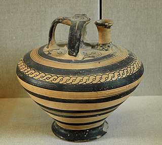
An artifact, or artefact, is a general term for an item made or given shape by humans, such as a tool or a work of art, especially an object of archaeological interest. In archaeology, the word has become a term of particular nuance and is defined as an object recovered by archaeological endeavor, which may be a cultural artifact having cultural interest.

The archaeology of Israel is the study of the archaeology of the present-day Israel, stretching from prehistory through three millennia of documented history. The ancient Land of Israel was a geographical bridge between the political and cultural centers of Mesopotamia and Egypt. Despite the importance of the country to three major religions, serious archaeological research only began in the 15th century. Although he never travelled to the Levant, or even left the Netherlands, the first major work on the antiquities of Israel is considered to be Adriaan Reland's Antiquitates Sacrae veterum Hebraeorum, published in 1708. Edward Robinson, an American theologian who visited the country in 1838, published its first topographical studies. Lady Hester Stanhope performed the first modern excavation at Ashkelon in 1815. A Frenchman, Louis Felicien de Saucy, embarked on early "modern" excavations in 1850. Today, in Israel, there are some 30,000 sites of antiquity, the vast majority of which have never been excavated.

The Mandara Mountains are a volcanic range extending about 190 km along the northern part of the Cameroon–Nigeria border, from the Benue River in the south to the north-west of Maroua in the north. The highest elevation is the summit of Mount Oupay, at 1,494 m (4,900 ft) above sea level.

Kapsiki (Ka-Tsepkye) is a people living on both sides of the border between North Cameroon and Northeast Nigeria. They are called Kapsiki in Cameroon, and Kamwe (Higi) in Nigeria. Together they amount to about 120,000 people. Their language, Psekiye or Kamwe, consists of eleven dialects including Nkafa, Sina, Ghye, Humsi, Dakwa and Tilli and belongs to the Chadic language family.

Kintampo complex is the period in prehistory that saw the transition to sedentism in West Africa, specifically in the Bono East region of Ghana and parts of eastern Côte d'Ivoire that began sometime between 2500-1400 BCE. Besides being a classic example of early forest dwellers in West Africa, Kintampo is significant because there is evidence of a drastic change in food production techniques due to the transition from nomadic hunter-gather lifestyles to life in stationary settlements. This change is known as sedentism and is typical of societies who have access to, or are developing systems of agriculture. Ceramic sculptures of humans and animals indicate that the Kintampo settlements were inhabited by practitioners of both pastoralism and horticulture.
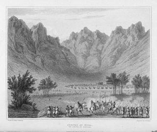
The Mandara Kingdom was an African kingdom in the Mandara Mountains of what is today Cameroon. The Mandara people are descended from the kingdom's inhabitants.

Mokolo is the departmental capital and largest city of the Mayo-Tsanaga department, in the Far North Province of Cameroon. It is the fourth largest city in the Far North Province, after Maroua, Yagoua, and Kousséri. It is located in the Mandara Mountains that run along the Cameroonian-Nigerian border.

The Far North Region, also known as the Extreme North Region, is the northernmost constituent province of the Republic of Cameroon. It borders the North Region to the south, Chad to the east, and Nigeria to the west. The capital is Maroua.
Mumba Cave, located near the highly alkaline Lake Eyasi in Karatu District, Arusha Region, Tanzania. The cave is a rich archaeological site noted for deposits spanning the transition between the Middle Stone Age and Late Stone Age in Eastern Africa. The transitional nature of the site has been attributed to the large presence of its large assemblage of ostrich eggshell beads and more importantly, the abundance of microlith technology. Because these type artifacts were found within the site it has led archaeologists to believe that the site could provide insight into the origins of modern human behavior. The cave was originally tested by Ludwig Kohl-Larsen and his wife Margit in their 1934 to 1936 expedition. They found abundant artifacts, rock art, and burials. However, only brief descriptions of these findings were ever published. That being said, work of the Kohl-Larsens has been seen as very accomplished due to their attention to detail, especially when one considers that neither was versed in proper archaeological techniques at the time of excavation. The site has since been reexamined in an effort to reanalyze and complement the work that has already been done, but the ramifications of improper excavations of the past are still being felt today, specifically in the unreliable collection of C-14 data and confusing stratigraphy.

Poverty Point State Historic Site/Poverty Point National Monument is a prehistoric earthwork constructed by the Poverty Point culture. The Poverty Point site is located in present-day northeastern Louisiana though evidence of the Poverty Point culture extends throughout much of the Southeastern Woodlands. The culture extended 100 miles (160 km) across the Mississippi Delta and south to the Gulf Coast. The Poverty Point site has been designated as a state historic site, U.S. National Monument, a U.S. National Historic Landmark, and UNESCO World Heritage Site. Located in the Southern United States, the site is 15.5 miles (24.9 km) from the current flow of the Mississippi River, and is situated on the edge of Macon Ridge, near the village of Epps in West Carroll Parish, Louisiana.
The Trinchera Cave Archeological District (5LA9555) is an archaeological site in Las Animas County, Colorado with artifacts primarily dating from 1000 BC to AD 1749, although there were some Archaic period artifacts found. The site was added to the National Register of Historic Places in 2001 and is located on State Trust Lands.
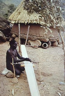
The Mafa also called Mafahay, is an ethnic group localized in northern Cameroon, Northern Nigeria and also scattered in other countries like Mali, Chad, Sudan, Burkina Faso and Sierra Leone.

On the Swahili Coast in southern Tanzania lie the ruins of a stone town known as Songo Mnara. The stone town was occupied from the 14th to 16th centuries. Songo Mnara has been recognized as a UNESCO World Heritage Site, along with nearby stone town Kilwa Kisiwani. In total, archaeologists have found six mosques, four cemeteries, and two dozen house blocks along with three enclosed open spaces on the island. Songo Mnara was constructed from rough-coral and mortar. This stonetown was built as one of many trade towns on the Indian Ocean.

Leopard's Kopje is an archaeological site, the type site of the associated region or culture that marked the Middle Iron Age in Zimbabwe. The ceramics from the Leopard's Kopje type site have been classified as part of phase II of the Leopard's Kopje culture. For information on the region of Leopard's Kopje, see the "Associated sites" section of this article.

Central Africa is generally considered to encompass ten countries which amounts to more than six million square kilometers or roughly the size of the United States west of the Mississippi River. Despite its large size, very little archaeological research has been done in the region.
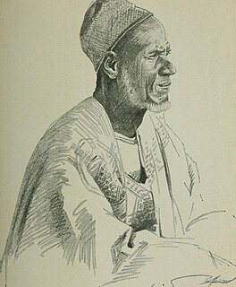
The Mandara people, also known as Wandala or Mandwara, are a Central African traditionlist ethnic group found in north Cameroon northeastern Nigeria, and southeastern Chad. They speak the Wandala language, which belongs to the Chadic branch of Afro-Asiatic languages found in northeastern Africa.
Daima is a mound settlement located in Nigeria, near Lake Chad, and about 5 kilometers away from the Nigerian frontier with Cameroon. It was first excavated in 1965 by British archaeologist Graham Connah. Radiocarbon dating showed the occupations at Daima cover a period beginning early in the first millennium BC, and ending early in the second millennium AD. The Daima sequence then covers some 1800 years. Daima is a perfect example of an archaeological tell site, as Daima’s stratigraphy seems to be divided into three periods or phases which mark separate occupations. These phases are called Daima I, Daima II, and Daima III. Although these occupations differ from each other in multiple ways, they also have some shared aspects with one another. Daima I represents an occupation of a people without metalwork; Daima II is characterized by the first iron-using people of the site; and Daima III represents a rich society with a much more complex material culture.


