
Richmond is a city in western Contra Costa County, California, United States. The city was incorporated on August 7, 1905, and has a city council. Located in the San Francisco Bay Area's East Bay region, Richmond borders San Pablo, Albany, El Cerrito and Pinole in addition to the unincorporated communities of North Richmond, Hasford Heights, Kensington, El Sobrante, Bayview-Montalvin Manor, Tara Hills, and East Richmond Heights, and for a short distance San Francisco on Red Rock Island in the San Francisco Bay.

Contra Costa County is a county located in the U.S. state of California, in the East Bay of the San Francisco Bay Area. As of the 2020 United States Census, the population was 1,165,927. The county seat is Martinez. It occupies the northern portion of the East Bay region of the San Francisco Bay Area and is primarily suburban. The county's name refers to its position on the other side of the bay from San Francisco. Contra Costa County is included in the San Francisco–Oakland–Berkeley, CA Metropolitan Statistical Area.

San Pablo is an enclave city in Contra Costa County, California, United States. The city of Richmond surrounds nearly the whole city. The population was 32,127 at the 2020 census. The current Mayor is Abel Pineda. Currently, the City Council consists of Abel Pineda, Patricia Ponce, Arturo Cruz, Elizabeth Pabon-Alvarado, and Rita Xavier. Ponce is the Vice Mayor, and Cruz, Pabon-Alvarado, and Xavier are Council Members. Dorothy Gantt is the city Clerk. Viviana Toledo is the city Treasurer.

AC Transit is an Oakland-based public transit agency serving the western portions of Alameda and Contra Costa counties in the East Bay of the San Francisco Bay Area. AC Transit also operates "Transbay" routes across San Francisco Bay to San Francisco and selected areas in San Mateo and Santa Clara counties. AC Transit is constituted as a special district under California law. It is governed by seven elected members. It is not a part of or under the control of Alameda or Contra Costa counties or any local jurisdictions.
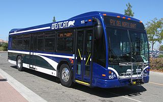
WestCAT is a public transportation service in western Contra Costa County. It is a service of the Western Contra Costa Transit Authority.
The West Contra Costa Unified School District is the school district for western Contra Costa County, California. It is based in Richmond, California. In addition to Richmond, the district covers the cities of El Cerrito, San Pablo, Pinole, and Hercules and the unincorporated areas of Bayview-Montalvin Manor, East Richmond Heights, El Sobrante, Kensington, North Richmond, and Tara Hills.

El Cerrito del Norte station is a Bay Area Rapid Transit (BART) station located on Cutting Boulevard in El Cerrito, California. The station is served by the Orange Line and Red Line. Located near San Pablo Avenue and Interstate 80, it serves as a regional transit hub for local AC Transit bus services, and for commuter feeder services from Solano, Napa, and Marin Counties in the North Bay plus western Contra Costa County. Opened in 1973, the station was renovated in 2017–2021 to add additional elevators, stairs, and lobby space.
California's 8th congressional district is a congressional district in the U.S. state of California. As of 2023, Democrat John Garamendi represents the district. Currently, the 8th district includes parts of the Bay Area counties of Contra Costa County and Solano County, including the cities of Vallejo, Fairfield, Richmond and parts of Martinez.

Parchester Village is a planned majority African-American village in northwestern Richmond, California that was the first in the state to sell to blacks.
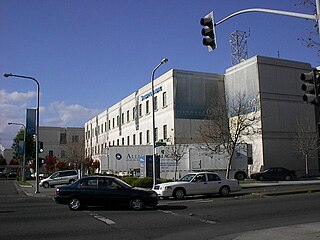
Kaiser Richmond Medical Center is a large Kaiser Permanente hospital in downtown Richmond, California which serves 77,000 members registered under its medical plans. It opened in 1995 replacing the historic 1942 Richmond Field Hospital that serviced Liberty shipyard workers and thus gave birth to the HMO. However it was deemed seismically unsafe and this new campus was built.
John Muir Health is a hospital network headquartered in Walnut Creek, California and serving Contra Costa County, California and surrounding communities. It was formed in 1997 from the merger of John Muir Medical Center and Mount Diablo Medical Center.
John E. Márquez is an American politician and activist who has held various positions in Richmond, California city government. For eighteen years, Márquez served as a city councilman. He was the first Latino to serve on the Richmond City Council. Originally he was an appointee to the council in 1985 and won an election to that seat in 1987; he subsequently lost his second bid in 1991. He was elected again in 1993 and twice more in 1997 and 2004. In 1990 and 1998, he served as vice mayor. Márquez was defeated for re-election in 2008, and lost a mayoral bid in 2001 to Gayle McLaughlin. In addition to his elected offices in the city of Richmond, he has held various other positions in Contra Costa County, California on various commissions.

Don Víctor Ramón Castro was a Californio ranchero, politician, and businessman. He was one of the largest landowners in Contra Costa and served as a Contra Costa County Supervisor. He operated one of the first ferries in the Bay Area.

Hercules Transit Center is a major commuter hub in the western Contra Costa County city of Hercules, California. It is anchored by WestCAT bus services. The center was originally on San Pablo Avenue. In August 2009, the transit center was relocated to the other side of I-80 with additional paid parking, which is $3/day.
The Contra Costa County Board of Supervisors is the governing body for Contra Costa County, California, in the San Francisco Bay Area's East Bay region. Members of the Board of supervisors are elected from districts, based on their residence.
Chelsea Wetlands is a riparian marsh on lower Pinole Creek and a tidal wetland at its mouth on San Pablo Bay, in Contra Costa County, northern California. It is located within the city of Hercules, in the East Bay region of the San Francisco Bay Area.

Macdonald 80 Shopping Center, or Macdonald 80, is a 200,000 sq. ft. (18,580m³) regional shopping mall in the North & East neighborhood in Richmond, California, anchored by a Target store. The center was largely demolished and rebuilt after suffering from urban decay and blight. It is the only entirely LEED certified mall. It is anchored by a large Target store.

John Gioia is an American politician. He has served on the Contra Costa County Board of Supervisors in Contra Costa County, California since 1998 and was re-elected three times. He served as chair in 2002, 2006 and 2010. John Gioia is a Democrat. Contra Costa supervisorial seats are non-partisan.
Abella Center formerly International Marketplace and originally El Portal Shopping Center is a mixed-use city services, business, shopping center and housing village transit-oriented development that was formerly a mall in San Pablo, California.

Seton Medical Center is a 398-bed hospital owned by AHMC Healthcare. Founded in San Francisco, the current facility is located in Daly City, California, United States. It is the largest employer in Daly City and is credited in part with attracting the initial influx of Filipino immigrants to the city, which has the highest concentration of Filipinos in the U.S.

