North Omaha is a community area in Omaha, Nebraska, in the United States. It is bordered by Cuming and Dodge Streets on the south, Interstate 680 on the north, North 72nd Street on the west and the Missouri River and Carter Lake, Iowa on the east, as defined by the University of Nebraska at Omaha and the Omaha Chamber of Commerce.
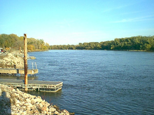
Cabanne's Trading Post was established in 1822 by the American Fur Company as Fort Robidoux near present-day Dodge Park in North Omaha, Nebraska, United States. It was named for the influential fur trapper Joseph Robidoux. Soon after it was opened, the post was called the French Company or Cabanné's Post, for the ancestry and name of its operator, Jean Pierre Cabanné, who was born and raised among the French community of St. Louis, Missouri.
East Omaha is a geographically designated community located in Omaha, Nebraska. Located three miles (5 km) from downtown Omaha, East Omaha is the site of Eppley Airfield, Omaha's main airport, and Carter Lake. This area was Omaha's first annexation, joining the city in 1854. Originally separated from Omaha by the Missouri River, a large section of the area's land was dissected by a ruling from the U.S. Supreme Court in 1892. Today, 2,500 houses, a school, grocery stores and a church that made up the original town have been demolished and replaced by several government facilities, the Eppley Airfield, and more.
North Omaha, Nebraska has a recorded history spanning over 200 years, pre-dating the rest of Omaha, encompassing wildcat banks, ethnic enclaves, race riots and social change. North Omaha has roots back to 1812 and the founding of Fort Lisa. It includes the Mormon settlement of Cutler's Park and Winter Quarters in 1846, a lynching before the turn of the twentieth century, the thriving 24th Street community of the 1920s, the bustling development of its African-American community through the 1950s, a series of riots in the 1960s, and redevelopment in the late 20th and early 21st century.
Significant events in the history of North Omaha, Nebraska include the Pawnee, Otoe and Sioux nations; the African American community; Irish, Czech, and other European immigrants, and; several other populations. Several important settlements and towns were built in the area, as well as important social events that shaped the future of Omaha and the history of the nation. The timeline of North Omaha history extends to present, including recent controversy over schools.
Fort Lisa (1812–1823) was established in 1812 in what is now North Omaha in Omaha, Nebraska by famed fur trader Manuel Lisa and the Missouri Fur Company, which was based in Saint Louis. The fort was associated with several firsts in Nebraska history: Lisa was the first European farmer in Nebraska; it was the first settlement by American citizens set up in the then-recent Louisiana Purchase; Lisa's wife was the first woman resident of European descent in Nebraska; and the first steamboat to navigate Nebraska waters, the Western Engineer, arrived at Fort Lisa in September 1819.
Saratoga Springs, Nebraska Territory, or Saratoga, was a boom and bust town founded in 1856 that thrived for several years. During its short period of influence the town grew quickly, outpacing other local settlements in the area including Omaha and Florence, and briefly considered as a candidate for the Nebraska Territorial capitol. Saratoga was annexed into Omaha in 1887, and has been regarded a neighborhood in North Omaha since then.
The history of Omaha, Nebraska, began before the settlement of the city, with speculators from neighboring Council Bluffs, Iowa staking land across the Missouri River illegally as early as the 1840s. When it was legal to claim land in Indian Country, William D. Brown was operating the Lone Tree Ferry to bring settlers from Council Bluffs to Omaha. A treaty with the Omaha Tribe allowed the creation of the Nebraska Territory, and Omaha City was founded on July 4, 1854. With early settlement came claim jumpers and squatters, and the formation of a vigilante law group called the Omaha Claim Club, which was one of many claim clubs across the Midwest. During this period many of the city's founding fathers received lots in Scriptown, which was made possible by the actions of the Omaha Claim Club. The club's violent actions were challenged successfully in a case ultimately decided by the U.S. Supreme Court, Baker v. Morton, which led to the end of the organization.
The neighborhoods of Omaha are a diverse collection of community areas and specific enclaves. They are spread throughout the Omaha metro area, and are all on the Nebraska side of the Missouri River.
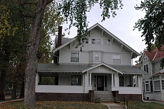
The Kountze Place neighborhood of Omaha, Nebraska is a historically significant community on the city's north end. Today the neighborhood is home to several buildings and homes listed on the National Register of Historic Places. It is located between North 16th Avenue on the east to North 30th Street on the west; Locust Street on the south to Pratt Street on the north. Kountze Place was annexed into Omaha in 1887. The neighborhood was built as a suburban middle and upper middle class enclave for doctors, lawyers, successful businessmen and other professional workers.

The culture of Omaha, Nebraska, has been partially defined by music and college sports, and by local cuisine and community theatre. The city has a long history of improving and expanding on its cultural offerings. In the 1920s, the Omaha Bee newspaper wrote, "The cultural future of Omaha seems as certain of greatness as the commercial future... The symphony orchestra, the Art institute, the Community Playhouse and other organizations are on firm foundations and Omaha is destined to be not only a bigger, but a better city, both financially and culturally." Reviewing Omaha's contemporary arts scene in 2007, the New York Times hailed the city as having "a kind of cultural awakening".

Hanscom Park is a historic neighborhood in Midtown Omaha, Nebraska. Its namesake public park is one of the oldest parks in Omaha, donated to the City in 1872. U.S. President Gerald R. Ford was born in a house in the Hanscom Park neighborhood. Its boundaries are Woolworth Street on the north, South 42nd on the west, Interstate 480 on the east and I-80 on the south.
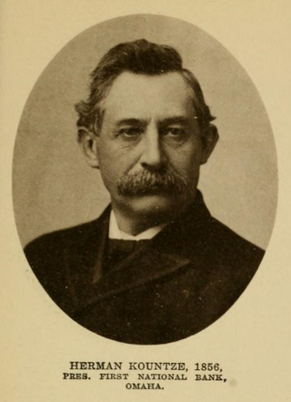
Herman Kountze was a powerful and influential pioneer banker in Omaha, Nebraska, during the late 19th century. After organizing the Kountze Brothers Bank in 1857 as the second bank in Omaha, Herman and his brothers Augustus, Charles and Luther changed the charter in 1863, opening the First National Bank of Omaha that year. Kountze was involved in a number of influential ventures around Omaha, including the development of the Omaha Stockyards and the Trans-Mississippi and International Exposition of 1898. Immediately after his death Kountze was regarded as one of Omaha's "old settlers". Today Kountze's First National Bank is the oldest bank west of the Mississippi River, and continues as a privately held company in its sixth generation of family ownership.
Forest Lawn Memorial Park, also known as Forest Lawn Cemetery, is located at 7909 Mormon Bridge Road in North Omaha, Nebraska. It was established in 1885 when the mutual Forest Lawn Cemetery Association was donated 100 acres (0.40 km2) in northwest of the city. In 1886, the first interment in the cemetery was the donor of the land, John H. Brackin. Forest Lawn is Omaha's largest cemetery and the burial location of many of Omaha's second generation of leadership.

Hummel Park is located at 11808 John J. Pershing Drive in North Omaha, Nebraska. Developed on 202 acres (0.82 km2) of land donated to the City of Omaha in 1930, the park was named after Joseph B. Hummel, a long time superintendent of Omaha's Parks and Recreation Department.

The economy of Omaha, Nebraska is linked to the city's status as a major commercial hub in the Midwestern United States since its founding in 1854. Dubbed the "Motor Mouth City" by The New York Times, Omaha is widely regarded as the telecommunications capital of the United States. The city's economy includes agriculture, food processing, insurance, transportation, healthcare and education. Warren Buffett of Berkshire Hathaway has lived in Omaha all of his life, as have the ConAgra Foods, Union Pacific Railroad and Mutual of Omaha Companies, and Kiewit Corporation, all Fortune 500 corporations.

Transportation in Omaha, Nebraska, includes most major modes, such as pedestrian, bicycle, automobile, bus, train and airplane. While early transportation consisted of ferries, stagecoaches, steamboats, street railroads, and railroads, the city's transportation systems have evolved to include the Interstate Highway System, parklike boulevards and a variety of bicycle and pedestrian trails. The historic head of several important emigrant trails and the First transcontinental railroad, its center as a national transportation hub earned Omaha the nickname "Gate City of the West" as early as the 1860s.
Significant events in the history of Omaha, Nebraska, include social, political, cultural, and economic activities.