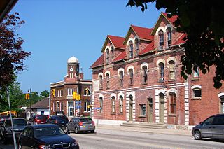
Gravenhurst is a town in the Muskoka Region of Ontario, Canada. It is located approximately 15 kilometres (9.3 mi) south of Bracebridge, Ontario. Mayor Paul Kelly was acclaimed on July 27, 2018. The Town of Gravenhurst includes a large area of the District of Muskoka, known to Ontarians as "cottage country." The town centre borders on two lakes: Lake Muskoka, which is the largest lake in the region, and Gull Lake, a smaller cottage-bordered lake. Another lake, Kahshe Lake, is situated 10 kilometres (6.2 mi) south of the town.
Burk's Falls is an incorporated village in the Almaguin Highlands region of Parry Sound District, Ontario, Canada, located 265 kilometres (165 mi) north of Toronto and 90 kilometres (56 mi) south of North Bay, Ontario. The village, and the waterfall on the site, were named by David Francis Burk of Oshawa, after he selected the land surrounding the waterfall in the Free Land Grant Act. Burk's Falls is part of the Magnetawan River waterway.

Lake Scugog is an artificially flooded lake in Scugog, Regional Municipality of Durham and the unitary city of Kawartha Lakes in central Ontario, Canada. It lies between the communities of Port Perry and Lindsay. The lake has been raised and lowered several times over its history. Though not technically part of the Kawartha lakes due to its shallow depths, it is often geographically linked to them. Its sole outflow, the Scugog River, connects to Sturgeon Lake. Lake Scugog is in the Great Lakes Basin and forms part of the Trent–Severn Waterway.
The Municipality of Trent Lakes is a lower-tier township in the rural, mostly wooded northern section of Peterborough County, Ontario, Canada. The municipality has a primarily cottage and tourist industry based economy but has grown year round residency due to its commute distance to the Greater Toronto Area.
Lake Temagami, formerly spelled as Lake Timagami, is a lake in Nipissing District in northeastern Ontario, Canada, situated approximately 80 km north of North Bay. The lake's name comes from Te-mee-ay-gaming, which means "deep water by the shore" in the Ojibwa language.

Bon Echo Provincial Park is a provincial park in southeastern Ontario north of Kaladar, approximately 6 kilometres (3.7 mi) north of Cloyne and located within the township boundaries of both Addington Highlands and North Frontenac.

Unorganized North Algoma District is an unorganized area in northeastern Ontario, Canada, comprising all areas in Algoma District, north of the Sault Ste. Marie to Elliot Lake corridor, which are not part of an incorporated municipality or a First Nation. It covers 44,077.03 km2 (17,018.24 sq mi) of land, and had a population of 5739 in 2016.

Minaki is an unincorporated area and community in Unorganized Kenora District in northwestern Ontario, Canada. It is located at the point where the Canadian National Railways transcontinental main line crosses the Winnipeg River, between Wade to the west and Ena Lake at the east, and was accessible only by rail until about 1960. It was a fuelling and watering point in the days of steam locomotives; now few trains stop in Minaki, though the thrice-weekly Via Rail transcontinental Canadian passenger trains will stop on request at the Minaki railway station.

Whiteshell Provincial Park is a 2,721 km2 park centrally located in Canada in the province of Manitoba. It is found in the southeast region of the province along the Manitoba-Ontario boundary, approximately 130 km east of the city of Winnipeg. The park is located in the Canadian Shield region and has many rivers, remote lakes, boreal forest and bare granite ridges. It has rare archeological sites of petroforms on flat granite ridges. The park is used year-round for nature-oriented recreation activities.

Big Rideau Lake is a lake in the municipalities of Tay Valley and Drummond/North Elmsley, Lanark County and Rideau Lakes, United Counties of Leeds and Grenville in Eastern Ontario, Canada. The lake is on the border between the two counties, 72 kilometres (45 mi) to the southwest of Ottawa. It is 32 kilometres (20 mi) long and is 6 kilometres (3.7 mi) wide, is much narrower at its northeastern end than at its southwestern end, and is part of the Saint Lawrence River drainage basin. It is the largest lake on the Rideau Canal, which was designated a UNESCO world heritage site in 2007.
Jumping Cariboo Lake, sometimes incorrectly spelled Jumping Caribou Lake, is a lake located within the Municipality of Temagami, in the Nipissing District, Ontario, Canada. It contains small islands and hidden bays. Ojibwa natives of the area have given the lake its name.

Magnetawan is a township in the Almaguin Highlands region of the Parry Sound District in the Canadian province of Ontario, as well as the name of the primary population centre in the township.
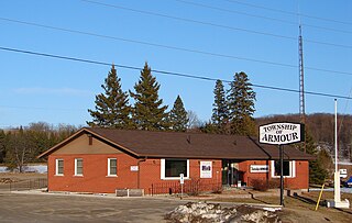
Armour is a township municipality in the Canadian province of Ontario.
Scouting and Guiding in Ontario has a long history. Although there is some dispute about the founding of the first Scouting Group, both 1st Merrickville and 1st St. Catharines Scout Group have a documented existence from 1908. In 1955, the 8th World Scout Jamboree was held at Niagara-on-the-Lake, Ontario. Scouting continues in Ontario to the present day, serving thousands of youths in programs that suit the environment in which they live.

Kennisis Lake is the 2nd largest lake in the Haliburton Highlands with a surface area of over 1,640 hectares in the area of Ontario just south west of Algonquin Provincial Park. From end to end, the lake is approximately 23 kilometres (14 mi) long. There is a smaller counterpart, named Little Kennisis Lake.

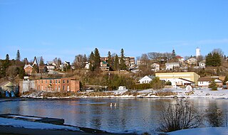
Lake Bernard is a freshwater lake 276 km (171 mi) north of Toronto and 6 km (3.7 mi) west of Algonquin Park in Parry Sound District, Ontario, Canada, between Huntsville and North Bay. It measures roughly 2.5 km (1.5 mi) across and 7 km (4.3 mi) long. The village of Sundridge lies on the northern shore of this clean, clear lake, which is otherwise surrounded by the municipal township of Strong.

Temagami, formerly spelled as Timagami, is a municipality in northeastern Ontario, Canada, in the Nipissing District with Lake Temagami at its heart.

Big Doe Camp was a boys' residential summer camp located on Big Doe Lake not far from the village of Burk's Falls, Ontario.

Four Mile Lake is a lake in the city of Kawartha Lakes in Central Ontario, Canada. The lake is 3.56 kilometres (2.21 mi) northeast of Coboconk, Ontario and 2.08 kilometres (1.29 mi) west of Burnt River. It is one of the Kawartha Lakes series of lakes and is in the Great Lakes Basin.

