Dollis Brook Viaduct

Last updated

Dollis Brook Viaduct
Dollis brook viaduct.JPG
The Dollis Brook Viaduct
Coordinates 51°36′18″N0°12′08″W / 51.6051°N 0.2022°W / 51.6051; -0.2022
Carries London Underground Northern line
CrossesDollis Road, Dollis Brook
Locale Finchley, London
Official nameDollis Brook Viaduct, Dollis Road Viaduct, Mill Hill Viaduct
Characteristics
DesignViaduct
MaterialBrick
Total length13 arches of 32 feet (9.8 m) span each
Height60 feet (18 m)
No. of spans13
History
Designer John Fowler, Walter Brydone
Construction start1863
Construction end1867
Opened22 August 1867
Location
Dollis Brook Viaduct

The Dollis Brook Viaduct, also known as the Dollis Road Viaduct, Dollis Viaduct or Mill Hill Viaduct, is a railway viaduct to the west of Finchley, North London, United Kingdom. It carries the London Underground's Northern line from Mill Hill East station to Finchley Central station. It is the highest point on the London Underground above ground level, reaching nearly 60 feet (18 m). It is located on a branch that was formerly part of the Edgware, Highgate and London Railway.

Contents

Etymology

The official name of the viaduct is taken from Dollis Brook which it crosses. The brook was marked on an 1877 Ordnance Survey map and the name may have originated from a farm called Dollis, previously in Hendon. This was earlier named Dalys in 1563, (the) Doles 1574, Dallys 1584 and in its current form of Dollis in 1822. This probably meant "the portions or shares of land (in the common field)", from the Middle English word dole. [1]

The name is not thought to be connected with the area of Dollis Hill, further south. Dollis Hill is thought to mean a "hill associated with a family called Dalley". [1]

History

The viaduct was designed by John Fowler and Walter Brydone, chief engineer for the Great Northern Railway (GNR) from 1855 to 1861. [2] The contractor that built the bridge was Smith, Knight & Co. The viaduct came into use on 22 August 1867 with the opening of the GNR's single-track Edgware, Highgate and London Railway line from Finsbury Park to Edgware, via Finchley and Mill Hill, which was authorised by an Act of Parliament in 1862. [3]

1934 Ordnance Survey map with the location of the viaduct marked Dollis Brook Viaduct map.png
1934 Ordnance Survey map with the location of the viaduct marked

Although built to carry two tracks, the viaduct initially carried only one. Following the construction of a branch northwards from Finchley to Barnet in 1872, the original Edgware route effectively became a branch of the newer line. [4] In the 1920s, the London and North Eastern Railway (LNER, successor to the GNR) planned to electrify the line but work was not carried out until the 1930s when the Northern Heights plan led to the doubling and electrification of the lines. This was in preparation for a transfer of the lines to the London Underground for it to form part of the system's Northern line.

The start of the Second World War prevented the plans being completed and only the section of the line to Mill Hill East was electrified and reopened in 1941, whilst the High Barnet branch was electrified in 1940. From this point on London Transport trains used only one of the tracks on the Mill Hill branch and the other track was soon lifted. Freight on the line lasted until 1964 when the line west of Mill Hill East was abandoned, leaving the present arrangement. [3] [4]

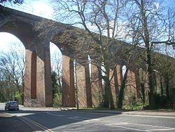
Length, span and architecture

Detailed view of viaduct's piers Dollis Brook Viaduct piers.jpg
Detailed view of viaduct's piers

The viaduct's 13 segmental arches carry it across the valley of the Dollis Brook, and over Dollis Road. [3] [5] Each arch spans 32 feet (9.8 m) at the springer level, and is based on tapered piers. In each pier there is an opening with an arched soffit and a dished invert. [3] The viaduct is made from brick. [3] It is the highest point on both the Northern line and the highest point on the London Underground above ground level, reaching nearly 60 feet (18 m). It is not, however, the highest altitude on the Underground system, which is near Amersham (Metropolitan line) in the Chiltern Hills, at 150 metres (490 ft) above sea level. [6]

Around the viaduct

Location of the Dollis Brook Viaduct
Edgware
BSicon uKBHFa.svg
BSicon uKBHFa.svg
High Barnet
unbuilt link
BSicon ueKRWgl.svg
BSicon uexKRW+r.svg
BSicon uSTR.svg
Edgware (LNER)
BSicon exKBHFaq.svg
BSicon uemKRZu.svg
BSicon exABZmg+r.svg
BSicon uSTR.svg
former LNER to Mill Hill East
Burnt Oak
BSicon uHST.svg
BSicon exSTR.svg
BSicon uHSTACC.svg
Totteridge & Whetstone
Colindale
BSicon uHST.svg
BSicon exSTR.svg
BSicon uHSTACC.svg
Woodside Park
BSicon uSTR.svg
BSicon exHST.svg
BSicon uSTR.svg
Mill Hill (The Hale) (LNER)
Hendon Central
BSicon uHST.svg
BSicon emENDE.svg
BSicon uHSTACC.svg
West Finchley
Brent Cross
BSicon uHST.svg
BSicon uBHF.svg
BSicon uSTR.svg
Mill Hill East
BSicon uSTR.svg
BSicon uhSTRae.svg
BSicon uSTR.svg
Dollis Brook Viaduct
BSicon uSTR.svg
BSicon uXBHF-L.svg
BSicon uXBHF-R.svg
Finchley Central
Golders Green
BSicon uHST.svg
BSicon uKRWl.svg
BSicon uKRWg+r.svg
BSicon uSTR.svg
BSicon uHST.svg
East Finchley
BSicon utSTRa.svg
BSicon utSTRa.svg

Below the viaduct can be found the Dollis Valley Greenwalk, a long-distance footpath between Moat Mount Open Space in Mill Hill and Hampstead Heath. This is designed to link many green spaces and wildlife corridors along the way and is approximately 10 miles (16 km) long. [7] [8] The geology nearby is of London Clay with small amounts of other rock types.

An examination in the late 19th century of the railway cutting between Finchley and Hendon station found a large extent of glacial beds and fossils, and these were thought to extend as far northwest as the viaduct. [9]

See also

Related Research Articles

<span class="mw-page-title-main">Northern line</span> London Underground line

The Northern line is a London Underground line that runs from North London to South London. It is printed in black on the Tube map. The Northern line is unique on the Underground network in having two different routes through central London, two southern branches and two northern branches. Despite its name, it does not serve the northernmost stations on the Underground, though it does serve the southernmost station at Morden, the terminus of one of the two southern branches.

<span class="mw-page-title-main">Finchley</span> District of London, England

Finchley is a large district of north London, England, in the London Borough of Barnet. Finchley is on high ground, 7 mi (11 km) north of Charing Cross. Nearby districts include: Golders Green, Muswell Hill, Friern Barnet, Whetstone, Mill Hill and Hendon.

<span class="mw-page-title-main">Mill Hill</span> Suburb in London, England

Mill Hill is a suburb in the London Borough of Barnet, England. It is situated around 10 miles (16 km) northwest of Charing Cross. It was in the historic county of Middlesex until 1965, when it became part of Greater London. Its population was 18,451 in 2011.

<span class="mw-page-title-main">London Borough of Barnet</span> Borough in the United Kingdom

The London Borough of Barnet is a local authority area on the northern outskirts of London. The borough was formed in 1965 from parts of the ceremonial counties of Middlesex and Hertfordshire. It is the second largest London borough by population with 389,344 inhabitants as of 2021, also making it the 17th largest district in England. The borough covers an area of 86.74 square kilometres (33 sq mi), the fourth highest of the 32 London boroughs, and has a population density of 45.8 people per hectare, which ranks it 25th.

<span class="mw-page-title-main">Whetstone, London</span> Human settlement in England

Whetstone is a suburb of London, in the London Borough of Barnet, bearing the postcode N20. It is served by an Underground station called Totteridge and Whetstone. Whetstone is around 7.8 miles North of Charing Cross and is a settlement in the London Borough of Barnet, previously part of the Borough of Finchley prior to the 1960s. The combined areas of Totteridge and Whetstone was, at the outset of the 21st century, found to be the 63rd-richest of the more than 9,000 wards of the United Kingdom.

<span class="mw-page-title-main">East Finchley tube station</span> London Underground station

East Finchley is a London Underground station in East Finchley in the London Borough of Barnet, north London. The station is on the High Barnet branch of the Northern line, between Finchley Central and Highgate stations, and is in Travelcard Zone 3.

<span class="mw-page-title-main">Highgate tube station</span> London Underground and former railway station

Highgate is a London Underground station and former railway station in Archway Road, in the London Borough of Haringey in north London. The station takes its name from nearby Highgate Village. It is on the High Barnet branch of the Northern line, between East Finchley and Archway stations, and is in Travelcard Zone 3.

<span class="mw-page-title-main">Mill Hill East tube station</span> London Underground station

Mill Hill East is a London Underground station in Mill Hill in the London Borough of Barnet, north London. The station is the terminus and only station of a single-track branch of the Northern line from Finchley Central station and is in Travelcard Zone 4. It is the least used station on the Northern line with 1.41 million passengers in 2022.

<span class="mw-page-title-main">Finchley Central tube station</span> London Underground station

Finchley Central is a London Underground station in the Church End area of Finchley, north London. The station is located on the High Barnet branch of the Northern line, between West Finchley and East Finchley stations; it is the junction for the short branch to Mill Hill East. The station is around 7 miles north-northwest of Charing Cross and is in Travelcard Zone 4.

<span class="mw-page-title-main">Dollis Brook</span>

Dollis Brook runs through the London Borough of Barnet in north London. It is a tributary of the River Brent, which is itself a tributary of the River Thames. The Dollis Valley Greenwalk follows almost all of Dollis Brook, apart from a short section at the beginning which passes through private land, and the London Loop follows it as far as Barnet Lane. The name Dollis is probably derived from the Middle English word 'dole', meaning the shares of land in the common field.

<span class="mw-page-title-main">Church End, Finchley</span> Human settlement in England

Church End is a locality within Finchley in the London Borough of Barnet in London, England. Aside from its church it centres on Finchley Central Underground station. Church End is an old village, now a suburban development, centred 7 miles (11 km) north-northwest of Charing Cross.

<span class="mw-page-title-main">Edgware, Highgate and London Railway</span> Former railway in North London

The Edgware, Highgate and London Railway was a railway in North London, England. The railway was a precursor of parts of London Underground's Northern line and was, in the 1930s, the core of an ambitious expansion plan for that line which was thwarted by the Second World War. Parts of the line were closed in the 1950s and have since been removed.

The London Borough of Barnet, located on the northern periphery of London and having much of the area within its boundaries in the Metropolitan Green Belt, has many parks and open spaces. In addition there are large areas taken over by cemeteries and golf courses, and part of Hampstead Heath.

<span class="mw-page-title-main">Muswell Hill railway station</span> Former railway station in England

Muswell Hill railway station was in Muswell Hill in North London, just north of the junction of Muswell Hill and Muswell Hill Place. Nothing remains of the station and Muswell Hill Primary School now occupies its former site. In the 1930s, plans were made to electrify the line and transfer the mainline service to London Underground's Northern line, but these were abandoned after the Second World War. The station closed for passengers in 1954 and goods in 1956.

<span class="mw-page-title-main">Cranley Gardens railway station</span> Former railway station in London

Cranley Gardens railway station was a station in the Muswell Hill area of north London. It was located between Highgate and Muswell Hill stations, at the junction of Muswell Hill Road and Cranley Gardens. Nothing remains of the station today and its site is now occupied by housing and a school. In the 1930s, plans were made to electrify the line and transfer the mainline service to London Underground's Northern line, but these were abandoned after the Second World War. The station closed for passengers in 1954 and for goods in 1957.

<span class="mw-page-title-main">Mill Hill (The Hale) railway station</span> Former railway station in England

Mill Hill (The Hale) was a station in Mill Hill in north London, on the now-removed railway between Mill Hill East station and Edgware railway station. It was located near the junction of Bunns Lane and Lyndhurst Avenue.

<span class="mw-page-title-main">Edgware railway station</span> Former railway station in England

Edgware was a London and North Eastern Railway (LNER) station located on Station Road in Edgware, north London. It was opened in 1867 and was in use as a passenger station until 1939, then as a goods yard until 1964.

The New Works Programme of 1935–1940 was the major investment programme delivered by the London Passenger Transport Board (LPTB), commonly known as London Transport, which had been created in 1933 to coordinate underground train, tram, trolleybus and bus services in the capital and the surrounding areas. The programme was to develop many aspects of the public transport services run by the LPTB and the suburban rail services of the Great Western Railway (GWR) and London and North Eastern Railway (LNER). The investment was largely backed by government assistance as well as by the issuing of financial bonds and was estimated to cost £42,286,000 in 1936.

<span class="mw-page-title-main">Dollis Valley Greenwalk</span> Ten-mile-long footpath in North London

The Dollis Valley Greenwalk is a footpath route in the London Borough of Barnet in London, England, between Moat Mount Nature Reserve in Mill Hill and Hampstead Heath. The route is designed to act as a link between the Capital Ring and the London Loop, and between the many green spaces and wildlife corridors along the way. It is approximately 10 miles (16 km) long. It mainly follows the Dollis Brook and is one of the many parks and open spaces in Barnet.

<span class="mw-page-title-main">Mutton Brook</span>

Mutton Brook is a stream which runs between East Finchley and Hendon in the London Borough of Barnet. It is a tributary of the River Brent, which is itself a tributary of the River Thames.

References

  1. 1 2 Mills, A. D. (2004). A Dictionary of London Place Names. Oxford: Oxford University Press. p. 66. ISBN   0-19-860957-4.
  2. "Panel of Historical Engineering Works". Institution of Civil Engineers . Retrieved 21 May 2009.[ permanent dead link ]
  3. 1 2 3 4 5 Smith, Denis (2001). Civil Engineering Heritage: London and the Thames Valley. London: Thomas Telford Ltd. pp. 167–168. ISBN   0-7277-2876-8 via Institution of Civil Engineers.
  4. 1 2 Brown, Joe (2005). London Railway Atlas. Hersham: Ian Allan Publishing. pp. 10–11. ISBN   0-7110-3137-1.
  5. "Hadley Wood News newsletter June 2007" (PDF). Hadley Wood News. June 2007. Retrieved 21 May 2009.[ permanent dead link ]
  6. "London Underground Key facts". Transport for London. Archived from the original on 29 May 2007. Retrieved 21 May 2009.
  7. "Barnet Council staff walk to talk about the Dollis Valley Green Walk". Edgware & Mill Hill Times. 16 April 2009. Retrieved 21 May 2009.
  8. "Dollis Valley Greenwalk". The Long Distance Walkers Association. 2008. Retrieved 21 May 2009.
  9. Walker, Henry (November 1871). "The Glacial Drift at Finchley". Nature. 5 (106): 27. Bibcode:1871Natur...5...27W. doi: 10.1038/005027c0 . S2CID   4038910.