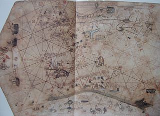
Domenico and Francesco Pizzigano

Last updated

Domenico and Francesco Pizzigano, known as the Pizzigani brothers, were 14th-century Venetian cartographers. Their surname is sometimes given as Pizigano (only one 'z') in older sources.

Contents

1367 chart

The 1367 chart of the Pizzigani brothers. (Full 10 MB Version) Pizigani 1367 Chart 1MB.jpg
The 1367 chart of the Pizzigani brothers. (Full 10 MB Version)

The Pizzigani brothers are principally known for the construction of a portolan chart, signed and dated 1367, currently held by the Biblioteca Palatina of Parma (Ms.Parm.1612). Measuring 138 by 92 cm, it is one of the largest maps of that era.

There is some controversy over the authorship. The note on the edge of the map, states (in one reading): ""MCCCLXVII. Hoc opus compoxuid franciscus pizigano veneciar et domnus pizigano In Venexia meffecit marcus die XII decembris.". The common assumption is that this refers to two brothers, Francesco Pizzigano and Domenico Pizzigano. Among the various alternative hypothesis is that Francesco was the son of Domenico, rather than his brother (and that Domenico might be dead by this date); that 'domnus' is a title for a priest, that the proper first name of the second author is Marco, that a close reading of the authorship note seems more like 'rardus' – or (Ge)rardus, Gerardo; that there might be three brothers (Francesco, Domenico, Marco/Gerardo), etc. [1] It was customary to refer to the brothers as the Pizigani (one z), until the discovery of the 1424 map of Zuane Pizzigano in the 20th century suggested a re-spelling to a double z. [2]

The Pizzigani portolan of 1367 is notable for going beyond the normal geographical boundaries of contemporary maps (Mediterranean and Black Seas) to include large swathes of the Atlantic Ocean, the northerly Scandinavian peninsula and the Baltic and Caspian Seas.

Atlantic islands off coast of Africa in 1367 map Pizzigani brothers 1367 map (Atlantic detail).jpg
Atlantic islands off coast of Africa in 1367 map

The 1367 Pizzigani chart gives an expanded depiction of the Canary Islands, showing eight of them, reflecting the knowledge accumulated since the 1339 Angelino Dulcert chart. It also includes the fantasy islands of Brasil (in the open ocean, with ships and dragons of Arab legend depicted around it). North of the real Canaries, the Pizzigani brothers also depicted a fictional cluster of Fortunate Islands, intended to capture Saint Brendan's Island, graced by an image of Brendan himself in monastic garb. The Pizzigani map is also the first in which the mythical Isle of Mam (southwest of Ireland) makes its first appearance.

Inscription of Antillia/Hercules in 1367 map. Pizigani 1367 Figure Legend.jpg
Inscription of Antillia/Hercules in 1367 map.

Some historians once believed the legendary island of Antillia , made famous in many 15th-century portolan charts, was first insinuated cartographically in the 1367 Pizigani brothers chart. On the western edge of the map, although there is no island depicted or mentioned, there is a disk with a picture of a man with hand outstretched, and an inscription, which some have read as saying "Here are statues which stand before the shores of Atullia (ante ripas Atulliae) and which have been set up for the safety of sailors; for beyond is the vile sea, which sailors cannot navigate". [3] Some scholars, especially in the 19th century, believed this Atullia was the first reference to "Antillia" on a map (e.g. Buache, Kretschmer, Nordenskiöld) [4] but this reading has been doubted since. Crone (1938) read it as ante ripas Getuliae (Getulia). [5] Beginning with Hennig (1945), the inscription has been commonly read as at temps Arcules or ante templum Arcules (from the time/temple of Hercules)., [6] almost doubtlessly a reference to the Pillars of Hercules, the non-plus ultra of ancient navigation, as transmitted via Arab sources, e.g. al-Masudi speaks of the "copper idols" of "King Hercules the Giant" marking the edge of the Green Sea of Darkness, [7] al-Idrisi places the marker 'idols' on islands away from the straits. [8]

The 1367 map also provides one of the first clear European depictions of the legendary "River of Gold" in west Africa. [9] This is the "western Nile" described by Arabic sources, notably the geographers al-Bakri and al-Idrisi. The western Nile is essentially the Senegal River and the Niger River, which were long assumed to be connected to each other, flowing through the gold-producing heart of the Mali Empire. The Pizzigani brothers called it the "Palolus" river, and place its source at a large lake in the "Mountains of the Moon" in the east (from which the Egyptian Nile was also believed to stem). [10] The Pizzigani show the river running west, pouring into the Atlantic Ocean somewhere south of "Caput finis Gozola" (Cape Non). The Pizzigani brothers place the actual gold mines on a river island which they call the "island of Palola" (probably the Buré gold district, which surrounded by branches of the upper Niger River, was mistaken for a river island).

The Pizzigani map also makes note of the legend of Prester John, noting that so much gold was found there, that it was even used to tile the roofs of houses and forge the weapons of his soldiers. [11]

Other charts

In addition to the 1367 chart (Biblioteca Palatina, Parma, Ms.Parm.1612), the Pizzigani brothers are believed to be responsible for four other maps:

Venetian cartographer Zuane Pizzigano, responsible for a famous 1424 portolan chart, containing the first unambiguous depiction of Antillia, is believed to be related to Domenico and Francesco Pizzigano (possibly a son of one of them). [15]

Related Research Articles

<span class="mw-page-title-main">Senegal River</span> River in West Africa

The Senegal River is a 1086 km (675 mi) long river in West Africa; much of its length marks part of the border between Senegal and Mauritania. It has a drainage basin of 270000 km2, a mean flow of 680 m3/s (24,000 cu ft/s), and an annual discharge of 21.5 km3 (5.2 cu mi). Important tributaries are the Falémé River, Karakoro River, and the Gorgol River. The river divides into two branches once it passes Kaédi The left branch, called the Doué, runs parallel to the main river to the north. After 200 km (120 mi) the two branches rejoin a few kilometers downstream of Podor.

<span class="mw-page-title-main">Antillia</span> 15th-century phantom island

Antillia is a phantom island that was reputed, during the 15th-century age of exploration, to lie in the Atlantic Ocean, far to the west of Portugal and Spain. The island also went by the name of Isle of Seven Cities.

<span class="mw-page-title-main">Cantino planisphere</span> Portuguese world map c.1502

The Cantino planisphere or Cantino world map is a manuscript Portuguese world map preserved at the Biblioteca Estense in Modena, Italy. It is named after Alberto Cantino, an agent for the Duke of Ferrara, who successfully smuggled it from Portugal to Italy in 1502. It measures 220 x 105 cm.

Angelino Dulcert, probably the same person known as Angelino de Dalorto, and whose real name was probably Angelino de Dulceto or Dulceti or possibly Angelí Dolcet, was an Italian-Majorcan cartographer.

<span class="mw-page-title-main">Portolan chart</span> Nautical charts, first made in the 13th century

Portolan charts are nautical charts, first made in the 13th century in the Mediterranean basin and later expanded to include other regions. The word portolan comes from the Italian portulano, meaning "related to ports or harbors", and which since at least the 17th century designates "a collection of sailing directions".

<span class="mw-page-title-main">Battista Agnese</span>

Battista Agnese was a cartographer from the Republic of Genoa, who worked in the Venetian Republic.

<i>Padrón Real</i>

The Padrón Real, known after 2 August 1527 as the Padrón General, was the official and secret Spanish master map used as a template for the maps present on all Spanish ships during the 16th century. It was kept in Seville, Spain by the Casa de Contratación. Ship pilots were required to use a copy of the official government chart, or risk the penalty of a 50 doblas fine. The map probably included a large-scale chart that hung on the wall of the old Alcázar of Seville. Well-known official cartographers and pilots who contributed to and used the map included Amerigo Vespucci, Diogo Ribeiro, Sebastian Cabot, Alonzo de Santa Cruz, and Juan Lopez de Velasco.

<span class="mw-page-title-main">Majorcan cartographic school</span> Medieval naval group

"Majorcan cartographic school" is the term coined by historians to refer to the collection of predominantly Jewish cartographers, cosmographers and navigational instrument-makers and some Christian associates that flourished in Majorca in the 13th, 14th and 15th centuries until the expulsion of the Jews. The label is usually inclusive of those who worked in Catalonia. The Majorcan school is frequently contrasted with the contemporary Italian cartography school.

<span class="mw-page-title-main">Pietro Vesconte</span>

Pietro Vesconte was a Genoese cartographer and geographer. A pioneer of the field of the portolan chart, he influenced Italian and Catalan mapmaking throughout the fourteenth and fifteenth centuries. He appears to have been the first professional mapmaker to sign and date his works regularly.

<span class="mw-page-title-main">Royllo</span>

Royllo, is a legendary phantom island that was once thought to be located in the Atlantic Ocean. It is probably identical with the island originally called Ymana in a 1424 nautical chart of Zuane Pizzigano. The island is usually depicted in many 15th-century maps as a small island located slightly to the west of the much larger island of Antillia. It is often found in the group insulae de novo repertae, or "newly discovered islands" along with other legendary islands.

<span class="mw-page-title-main">Giovanni da Carignano</span>

Giovanni da Carignano, or Johannes de Mauro de Carignano, was a priest and a pioneering cartographer from Genoa.

Gabriel de Vallseca, also referred to as Gabriel de Valseca and Gabriel de Valsequa was a cartographer of Jewish descent connected to the Majorcan cartographic school. His most notable map is the portolan of 1439, containing the first depiction of the recently-discovered Azores islands.

<span class="mw-page-title-main">Zuane Pizzigano</span>

Zuane Pizzigano, was a 15th-century Venetian cartographer. He is the author of a famous 1424 portolan chart, the first known to depict the phantom islands of the purported Antillia archipelago, in the north Atlantic Ocean.

The Weimar map is an anonymous 15th-century Italian portolan chart, held by the Grand Ducal Library of Weimar. Although frequently dated as 1424, most historians believe it was probably composed a half century later. The author is unknown, although said to be a member of the Freducci family of cartographers of Ancona, most probably Conte di Ottomano Freducci. Faint and fragile, the Weimar map is rarely photographed and has been hard to decipher.

The island of Satanazes is a legendary island once thought to be located in the Atlantic Ocean, and depicted on many 15th-century maps.

<span class="mw-page-title-main">Medici-Laurentian Atlas</span>

The Medici-Laurentian Atlas, also known simply as the Medici Atlas, is an anonymous 14th-century set of maps, probably composed by a Genoese cartographer and explicitly dated 1351, although most historians believe it was composed, or at least retouched, later. The atlas is currently held by the Biblioteca Medicea Laurenziana in Florence, Italy.

<span class="mw-page-title-main">Battista Beccario</span>

Battista Beccario, also known as Baptista Beccharius, was a 15th-century Genoese cartographer.

The Corbitis Atlas is a late 14th-century atlas of four portolan charts, composed by an anonymous Venetian cartographer, and held by the Biblioteca Nazionale Marciana in Venice, Italy.

<span class="mw-page-title-main">Cornaro Atlas</span> Venetian collection of nautical charts and tracts

The Cornaro Atlas is an extensive Venetian collection of nautical charts and tracts, currently held in the Egerton Collection of manuscripts of the British Library.

<i>La Cartografía Mallorquina</i>

La Cartografía Mallorquina is a book of essays on the Majorcan portolans written by Professor Julio Rey Pastor with the collaboration of Ernesto García Camarero. It is a scholarly essay, a key element in the study of portolans, especially those made by Majorcans as half of the book is devoted to the study of more than 400 Majorcan portolans existing worldwide.

References

  1. For details, see Longhena (1907, 1927).
  2. e.g. Astengo (2007)
  3. as cited in Crone (1938: p.260)
  4. Jean-Nicholas Buache (1806: p.25-26), Konrad Kretschmer (1892: 195-7), A.E. Nordenskiöld (1897: p.164).
  5. Crone (1938). Although Crone later (1947) considers other readings.
  6. Hennig (1945). This reading is acknowledged by Crone (1947) and embraced by Armando Cortesão (1954 (1975) , p.106])
  7. Beazley (1897, Vol. I p.465.
  8. Crone (1938: p.262). Crone (1937) notes the elasticity of the exact location of Hercules's pillars in 15th-century charts. Cortesão (1954 (1975):p.74) notes that an inscription about Hercules's "statues" to mark the edge of safe navigation was common practice in Arab charts.
  9. Formally, its depiction of the "River of Gold" is preceded by the 1351 Laurentian Medici Atlas, but the dating of the Medici atlas is very dubious and elastic, and maybe later than the Pizzigani brothers.
  10. Major (1868: p.112)
  11. Russell (2000: p.122)
  12. For the reference, see BNF citation. This map is a direct copy of the relevant map of Syria in the Liber of Marino Sanuto. See also Campbell (2011: Supp. A)
  13. T. Fischer (1886: p.148-51)
  14. 1 2 Campbell (2011b: here)
  15. Cortesão (1953, 1954)

Sources