Gallery
 1898 Sikhim and Adjoining Territories by Laurence Waddell
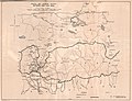 1903 by William O'Connor
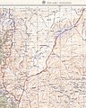 1955 by US Army Map Service
 1965 by US Central Intelligence Agency
Dongkya or Dongkhya range [a] , is a mountain range in the Himalayas that forms the eastern border of Sikkim, a state of India. Its northern tip extends to Dongkha La, and as it moves southwards, sometimes referred to as the Chola range, [2] [3] it is cut by Cho La, Yak La, Nathu La and Jelep La passes. [4] [5]
S. K. Samanta explains in the Indian Journal of Landscape Systems and Ecological Studies, [6]
From Pauhunri emanates a large thrust, Dongkiya Range which strides southward for about 50 kilometre. It is separated from Tsen-gui kang by a fracturing belt of the Lachung chhu valley and leans over the Chola Range just north of Cho la (4435m).... The stream Rate chhu originates near Cho la which makes the boundary between North and East Sikkim, and ultimately plunges into the river Tista near Dikchu. The Range Chola extends further south for 20 kilometre along the eastern boundary of East Sikkim and acts as the water-divide between Rangpo-De chhu valleys lying in the district and Ammo chhu in Tibet..... De chhu excavates a narrow valley in south-eastern portion of the area, cuts deeply the last tip of Chola Range and ultimately flows southward through a glen to mark the boundary between Darjiling district and Bhutan.
It was established as the border between Sikkim and Tibet's Chumbi Valley by the 1890 Convention of Calcutta reached between British India and Qing China. The Convention deemed the Dongkya Range to end at Mount Gipmochi at the southern end, which was defined as the trijunction between India, Tibet and Bhutan. However the Doklam plateau at the southern end gives rise to complications and the present day border dispute between Bhutan and China.
Dongkya Range is politically important, however S. G. Burrard, H. H. Hayden and A. Heron comment that while Dongkya Range is politically important, "but from a Himalayan point of view too great a topographical emphasis was given to them upon maps". [7]


27°41′N88°50′E / 27.683°N 88.833°E
| | This Asia mountain, mountain range, or peak related article is a stub. You can help Wikipedia by expanding it. |

The Himalayas, or Himalaya is a mountain range in Asia, separating the plains of the Indian subcontinent from the Tibetan Plateau. The range has several peaks exceeding an elevation of 8,000 m (26,000 ft) including Mount Everest, the highest mountain on Earth. The mountain range runs for 2,400 km (1,500 mi) as an arc from west-northwest to east-southeast at the northern end of the Indian subcontinent.

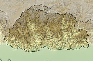
Bhutan is a sovereign country at the crossroads of East Asia and South Asia, located towards the eastern extreme of the Himalayas mountain range. It is fairly evenly sandwiched between the sovereign territory of two nations: first, the People's Republic of China (PRC) on the north and northwest. There are approximately 477 kilometres (296 mi) of border with the country's Tibet Autonomous Region (TAR), or simply Tibet. The second nation is the Republic of India on the south, southwest, and east; there are approximately 659 kilometres (409 mi) with the states of Arunachal Pradesh, Assam, West Bengal, and Sikkim, in clockwise order from the kingdom. Bhutan's total borders amount to approximately 1,139 kilometres (708 mi). The Indian state of Sikkim to the west, the India to the south, and the Assam state of India to the southeast are other close neighbours; the former two are separated by only very small stretches of Indian territory.

Kalimpong is a town and the headquarters of an eponymous district in the Indian state of West Bengal. It is located at an average elevation of 1,250 metres (4,101 ft). The town is the headquarters of the Kalimpong district. The region comes under Gorkhaland Territorial Administration which is an autonomous governing body within the state of West Bengal. The Indian Army's 27 Mountain Division is located on the outskirts of the city.
Jelep La elevation 14,390 feet (4,390 m), is a high mountain pass between Sikkim, India and Tibet Autonomous Region, China. It is on a route that connects Lhasa to India. The pass is about 4 km (2.5 mi) south of Nathu La and is slightly higher. It was frequently used for trade between Tibet and India during the British Raj, with Kalimpong serving as the contact point. The Menmecho Lake lies below the Jelep La.

Nathu La(Tibetan: རྣ་ཐོས་ལ་, Wylie: Rna thos la, THL: Na tö la, Sikkimese: རྣ་ཐོས་ལ་) is a mountain pass in the Dongkya Range of the Himalayas between China's Yadong County in Tibet, and the Indian states of Sikkim. But minor touch of Bengal in South Asia. The pass, at 4,310 m (14,140 ft), connects the towns of Kalimpong and Gangtok to the villages and towns of the lower Chumbi Valley.

Yadong County, also known by its Tibetan name Dromo/TromoCounty is a frontier county and trade-market of the Tibet Autonomous Region of China, part of its Shigatse Prefecture.

The Chumbi Valley, called Dromo or Tromo in Tibetan, is a valley in the Himalayas that projects southwards from the Tibetan plateau, intervening between Sikkim and Bhutan. It is coextensive with the administrative unit Yadong County in the Tibet Autonomous Region of China. The Chumbi Valley is connected to Sikkim to the southwest via the mountain passes of Nathu La and Jelep La.

The Nathu La and Cho La clashes, sometimes referred to as Indo-China War of 1967, Sino-Indian War of 1967, were a series of border clashes between China and India alongside the border of the Himalayan Kingdom of Sikkim, then an Indian protectorate.
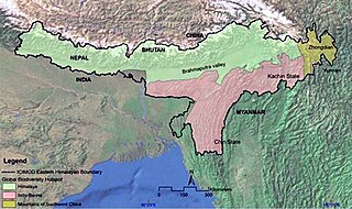
The Eastern Himalayas extend from eastern Nepal across Northeast India, Bhutan, the Tibet Autonomous Region to Yunnan in China and northern Myanmar. The climate of this region is influenced by the monsoon of South Asia from June to September. It is a biodiversity hotspot, with notable biocultural diversity.

Yatung or Yadong, also known as Shasima , is the principal town in the Chumbi Valley or Yadong County in the Tibet Autonomous Region of China. It is also its administrative headquarters.
The mountains of Bhutan are some of the most prominent natural geographic features of the kingdom. Located on the southern end of the Eastern Himalaya, Bhutan has one of the most rugged mountain terrains in the world, whose elevations range from 160 metres (520 ft) to more than 7,000 metres (23,000 ft) above sea level, in some cases within distances of less than 100 kilometres (62 mi) of each other. Bhutan's highest peak, at 7,570 metres (24,840 ft) above sea level, is north-central Gangkhar Puensum, close to the border with Tibet; the third highest peak, Jomolhari, overlooking the Chumbi Valley in the west, is 7,314 metres (23,996 ft) above sea level; nineteen other peaks exceed 7,000 metres (23,000 ft). Weather is extreme in the mountains: the high peaks have perpetual snow, and the lesser mountains and hewn gorges have high winds all year round, making them barren brown wind tunnels in summer, and frozen wastelands in winter. The blizzards generated in the north each winter often drift southward into the central highlands.
Cho La or Cho-la is a mountain pass in the Chola range of the Himalayas. It connects the Indian state of Sikkim with China's Tibet Autonomous Region. It is situated around four miles to the north-west of Nathu La.

Gipmochi is a mountain in the Lower Himalayas in south central Asia. Rising to a height of 14,523 feet (4,427 m), the mountain sits on the border between the northern Indian state of Sikkim and Bhutan. China claims Gipmochi as the China–India–Bhutan tri-junction point. Bhutan and India, however, claim that the tri-junction is 6.5 km to the north, at Batang La.

Doklam, called Donglang by China, is an area in Chumbi Valley with a high plateau and a valley, lying between China's Yadong County to the north, Bhutan's Ha District to the east and India's Sikkim state to the west. Since the 1960s, China and Bhutan have disputed sovereignty over the Doklam area. The dispute has not been resolved despite several rounds of border negotiations between Bhutan and China. The area is of strategic importance to all three countries.

Chumbi is a historic village in the Chumbi Valley or the Yadong County of the Tibet Autonomous Region of China. It is in the valley of the Amo Chu River, where the route from Sikkim's Cho La Pass meets the Amo Chu Valley. The "Chumbi Valley" of the European nomenclature derives its name from the village of Chumbi. It was the administrative center of the lower Chumbi Valley until the Chinese take-over of Tibet in 1950, after which Yatung became its headquarters. Chumbi is also associated with the Sikkim's royal family, which had a summer palace in the village.
Rinchengang (Tibetan: རིན་ཆེན་སྒང, Wylie: rin chen sgang, THL: rin chen gang, ZYPY: Rinqêngang) or Renqinggang (Chinese: 仁青岗村; pinyin: Rén qīng gǎng cūn) is a town in the Chumbi Valley and the headquarters of the Xia Yadong Township of Yadong County, Tibet region of China. It is in the valley of Amo Chu where the route from Sikkim's Jelep La pass meets Amo Chu. It is also close to the Bhutan–China border, which is currently in dispute. In December 2018, Rinchengang village had a population of around 550 people. The inhabitants are engaged in animal grazing or work as forest rangers. Some also carry supplies to Chinese border troops.
Xiayadong Township, known in Tibetan as Dromo Mechü is a township in the Chumbi Valley in Yadong County, Shigatse, in the Tibet Autonomous Region of China. Much of the township's area comprises disputed territory: the township spans an area of 204.7 square kilometres (79.0 sq mi), excluding disputed territory, and 650.88 square kilometres (251.31 sq mi) including it. Xiayadong Township's population totaled 897 as of 2018.

Old Yatung, originally just "Yatung", with a native Tibetan spelling of Nyatong or Myatong, is a location 2 miles west of Rinchengang in the lower Chumbi Valley in the present day Yadong County of Tibet. It is in the valley of Yatung Chu, the river that flows down from Jelep La to join the Amo Chu river near Rinchengang. But according to travel writer John Easton, Yatung is actually a hill top location adjoining the valley, which has a historic Kagyu monastery. The monastery itself lies along the route from the Nathu La pass via Champithang.
Chema or Phema (Tibetan: བྱེ་མ, Wylie: bye ma, THL: jé ma, ZYPY: Qêma; Chinese: 切玛; pinyin: Qiè mǎ), is a village in the Chumbi Valley or Yadong County in the Tibet region of China. It is in the valley of Amo Chu where the route from Sikkim's Nathu La pass meets the Amo Chu valley. Chema is in the Xiayadong Township.
Kupup is a hamlet in the Indian state of Sikkim near the border with China. It lies in a transverse valley below the Dongkya Range, close to the Jelep La pass. A nearby moraine ridge across the valley forms part of the watershed between the Teesta and Dichu river basins. To the southeast of the ridge is the lake Bitang Tso, also called the Elephant Lake or Kupup Lake, from which the Dichu river is conventionally believed to originate.