
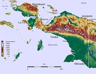
Papua is a province of Indonesia, comprising the northern coast of Western New Guinea together with island groups in Cenderawasih Bay to the west. It roughly follows the borders of Papuan customary region of Tabi Saireri. It is bordered by nation of Papua New Guinea to the east, the Pacific Ocean to the north, Cenderawasih Bay to the west, and the provinces of Central Papua and Highland Papua to the south. The province also shares maritime boundaries with Palau in the Pacific. Following the splitting off of twenty regencies to create the three new provinces of Central Papua, Highland Papua, and South Papua on 30 June 2022, the residual province is now restricted to the northern part of that territory and to the islands in Cenderawasah Bay, and is divided into eight regencies and one city (kota), the latter being the provincial capital of Jayapura. The province has a large potential in natural resources, such as gold, nickel, petroleum, etc. Papua, along with five other Papuan provinces, has a higher degree of autonomy level compared to other Indonesian provinces.

West Papua, formerly Irian Jaya Barat, is an Indonesian province located in Indonesia Papua. It covers most of the two western peninsulas of the island of New Guinea: the eastern half of the Bird's Head Peninsula and the whole of the Bomberai Peninsula, along with nearby smaller islands. The province is bordered to the north by the Pacific Ocean, to the west by Southwest Papua Province, the Halmahera Sea and the Ceram Sea, to the south by the Banda Sea, and to the east by the province of Central Papua and the Cenderawasih Bay. Manokwari is the province's capital and largest city. With an estimated population of 569,570 in mid-2023, West Papua is the least populous province in Indonesia after South Papua, following the separation off in 2022 of the western half of the Bird's Head Peninsula to create the new province of Southwest Papua, containing 52% of what had been West Papua's population. Its population density is similar to Russia.

Sorong is the largest city and the capital of the Indonesian province of Southwest Papua. The city is located on the western tip of the island of New Guinea with its only land borders being with Sorong Regency. It is the gateway to Indonesia's Raja Ampat Islands, species rich coral reef islands in an area considered the heart of the world's coral reef biodiversity. It also is the logistics hub for Indonesia's thriving eastern oil and gas frontier. Sorong experienced rapid growth during the decade from 2010, and further growth is anticipated as Sorong becomes linked by road to other frontier towns in Papua's Bird's Head Peninsula. The official estimate of population as of mid 2023 was 294,978 - comprising 154,543 males and 140,435 females. The suburban area of Sorong city contains tropical rainforest and mangrove forest that has increasingly become popular as ecotourism attractions especially for birdwatching or wildlife watching.

Kotabaru Regency is one of the eleven regencies in the Indonesian province of South Kalimantan. It consists of two parts; the smaller but more populated insular part comprises Laut Island, the largest island off the coast of Kalimantan, together with the smaller Sebuku Island off Laut Island's east coast and other even smaller islands nearby; the larger but less populated part consists of the 12 districts on the mainland of Kalimantan. The regency as a whole has an area of 9,480.17 km2, and had a population of 290,142 at the 2010 Census and 325,622 at the 2020 Census. The official estimate as at mid 2023 was 329,641, of whom 177,148 were in the insular part and 152,493 in the mainland part of the regency. The regency seat is located at the large town of Kotabaru at the northern tip of Laut Island.
Misool, formerly spelled Mysol or Misol, is one of the four major islands in the Raja Ampat Islands in Southwest Papua, Indonesia. Its area is 2,034 km2. The highest point is 561 m and the main towns are Waigama, located on the island's northwest coast, and Lilinta on the island's southeast coast.

Salawati is one of the four major islands in the Raja Ampat Islands in Southwest Papua, Indonesia. Its area is 1,623 km2. Salawati is separated from New Guinea to the southeast by the Sele Strait, and from Batanta to the north by the Pitt Strait.
This is a list of some of the regions of Indonesia. Many regions are defined in law or regulations by the central government. At different times of Indonesia's history, the nation has been designated as having regions that do not necessarily correlate to the current administrative or physical geography of the territory of the nation.

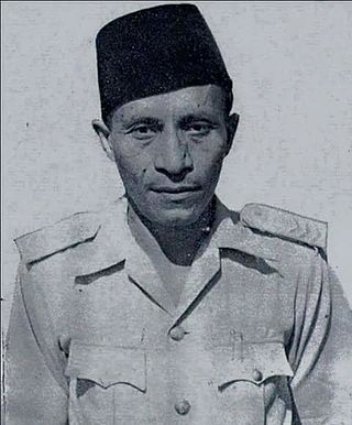
Frans Kaisiepo was an Indonesian Papuan. He served as the fourth Governor of Papua Province. In 1993, Kaisiepo was posthumously declared a National Hero of Indonesia for his lifelong efforts to unite West Irian with Indonesia. As the representative of Papua province, he was involved in the Malino Conference, where the formation of the United States of Indonesia was discussed.

New Guinea is the world's second-largest island, with an area of 785,753 km2 (303,381 sq mi). Located in Melanesia in the southwestern Pacific Ocean, the island is separated from Australia by the 150-kilometre wide Torres Strait, though both landmasses lie on the same continental shelf, and were united during episodes of low sea level in the Pleistocene glaciations as the combined landmass of Sahul. Numerous smaller islands are located to the West and East. The island's name was given by Spanish explorer Yñigo Ortiz de Retez during his maritime expedition of 1545 due to the resemblance of the indigenous peoples of the island to those in the African region of Guinea.

Operation Trikora was a combined Soviet-Indonesian military operation which aimed to seize and annex the Dutch overseas territory of Netherlands New Guinea in 1961 and 1962. After negotiations, the Netherlands signed the New York Agreement with Indonesia on 15 August 1962, relinquishing control of Western New Guinea to the United Nations.
The West New Guinea dispute (1950–1962), also known as the West Irian dispute, was a diplomatic and political conflict between the Netherlands and Indonesia over the territory of Dutch New Guinea. While the Netherlands had ceded sovereignty over most of the Dutch East Indies to Indonesia on 27 December 1949 following an independence struggle, it retained control over its colony on the western half of New Guinea. The Indonesian government claimed this territory as well, on the basis that it had belonged to the Dutch East Indies and that the new Republic of Indonesia was the legitimate successor to the former Dutch colony.
Sultan Zainal Abidin Alting Syah was the 26th Sultan of Tidore in Maluku Islands, reigning from 1947 to 1967. He was also the appointed Governor of Irian Barat in 1956–1962 before the actual inclusion of Irian Barat in Indonesia, serving official Indonesian claims against Dutch colonial rule.

Izaac Hindom was an Indonesian bureaucrat and politician who served as the governor of Irian Jaya from 1982 until 1988.

The Kingdom of Kaimana or Kingdom of Sran is one of the oldest Muslim kingdoms in West Papua, now Indonesia. The kingdom was established by Imaga, with the title Rat Sran Nati Pattimuni, traditionally in 1309.
2022–23 Liga 3 was the seventh season of the Liga 3 under the current name and the eighth season under the current league structure, and the only amateur league football competition in Indonesia. The tournament was organized by Provincial Association of PSSI for the provincial round and PSSI for the national round.
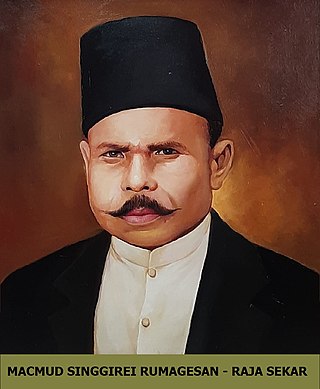
Machmud Singgirei Rumagesan was an Indonesian Papuan king of Sekar and pro-integration activist from West Papua. He founded the movement Gerakan Tjendrawasih Revolusioner Irian Barat (GTRIB) in 1953, and became the member of Supreme Advisory Council in 1959. On 10 November 2020, Singgirei Rumagesan was posthumously declared a National Hero of Indonesia for his lifelong efforts to unite West Irian with Indonesia.

Southwest Papua is the 38th province of Indonesia to be created, and was split off from West Papua on 8 December 2022. Despite being named southwest, it is a misnomer and this province is actually located in the northwest edge of Papua. The province comprises the Greater Sorong area which consists of Sorong City, Sorong Regency, South Sorong Regency, Maybrat Regency, Tambrauw Regency, and Raja Ampat Regency. The Bill (RUU) on the Establishment of the Southwest Papua Province was passed into law and therefore it became the 38th province in Indonesia with effect from 8 December 2022.

The Salawati Kingdom is the Islamic kingdom that once stood in Salawati Island, Raja Ampat Regency, Southwest Papua. The center of the Salawati kingdom was located in the Samate village which is currently located in the North Salawati district.

Persatuan Sepakbola Sekretaris Daerah Maybrat is an Indonesian football club based at the Ella Football Field, Ayamaru District, Maybrat Regency, Southwest Papua. The team competes in the Liga 4 Southwest Papua zone.
Putra Doom Football Club is an Indonesian football club based in Doom Island, Sorong City, Southwest Papua. The team competes in the Liga 4 Southwest Papua zone.


