
The Red Line is a rapid transit line operated by the Massachusetts Bay Transportation Authority (MBTA) as part of the MBTA subway system. The line runs south and east underground from Alewife station in North Cambridge through Somerville and Cambridge, surfacing to cross the Longfellow Bridge then returning to tunnels under Downtown Boston. It continues underground through South Boston, splitting into two branches on the surface at JFK/UMass station. The Ashmont branch runs southwest through Dorchester to Ashmont station, where the connecting light rail Ashmont–Mattapan High Speed Line continues to Mattapan station. The Braintree branch runs southwest through Quincy and Braintree to Braintree station.

Dorchester is a Boston neighborhood comprising more than 6 square miles (16 km2) in the City of Boston, Massachusetts, United States. Originally, Dorchester was a separate town, founded by Puritans who emigrated in 1630 from Dorchester, Dorset, England, to the Massachusetts Bay Colony. This dissolved municipality, Boston's largest neighborhood by far, is often divided by city planners in order to create two planning areas roughly equivalent in size and population to other Boston neighborhoods.

The Ashmont–Mattapan High-Speed Line, commonly referred to as the Mattapan Trolley, is a partially grade-separated light rail line which forms part of the MBTA's Red Line rapid transit line. The line, which runs through Boston and Milton, Massachusetts, opened on August 26, 1929, as a conversion of a former commuter rail line. It exclusively uses PCC streetcars built in the 1940s. Passengers must transfer at Ashmont to access the rest of the Red Line, which uses heavy rail metro rolling stock.

JFK/UMass station is a Massachusetts Bay Transportation Authority (MBTA) intermodal transfer station, located adjacent to the Columbia Point area of Dorchester, Boston, Massachusetts. It is served by the rapid transit Red Line; the Greenbush Line, Kingston/Plymouth Line, and Middleborough/Lakeville Line of the MBTA Commuter Rail system, and three MBTA bus routes. The station is named for the John F. Kennedy Presidential Library and Museum and the University of Massachusetts Boston, both located nearby on Columbia Point.

Mattapan is a neighborhood in Boston, Massachusetts. Historically and for legal processes a section of Dorchester, Mattapan became a part of Boston when Dorchester was annexed in 1870. Mattapan is the original Native American name for the Dorchester area, possibly meaning "a place to sit." At the 2010 census, it had a population of 36,480, with the majority of its population immigrants.

The Old Colony Railroad (OC) was a major railroad system, mainly covering southeastern Massachusetts and parts of Rhode Island, which operated from 1845 to 1893. Old Colony trains ran from Boston to points such as Plymouth, Fall River, New Bedford, Newport, Providence, Fitchburg, Lowell and Cape Cod. For many years the Old Colony Railroad Company also operated steamboat and ferry lines, including those of the Fall River Line with express train service from Boston to its wharf in Fall River where passengers boarded luxury liners to New York City. The company also briefly operated a railroad line on Martha's Vineyard, as well as the freight-only Union Freight Railroad in Boston. The OC was named after the "Old Colony", the nickname for the Plymouth Colony.

Dorchester Avenue is a street in Boston, Massachusetts, running from downtown south via South Boston and Dorchester to the border with Milton, where it ends. Built as a turnpike, the Dorchester Turnpike, it is mostly straight.

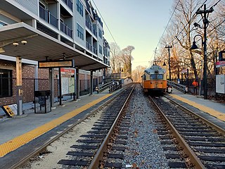
Ashmont station is a Massachusetts Bay Transportation Authority (MBTA) intermodal transit station located at Peabody Square in the Dorchester neighborhood of Boston, Massachusetts. It is the southern terminus of the Ashmont branch of the rapid transit Red Line, the northern terminus of the connecting light rail Ashmont–Mattapan High-Speed Line, and a major terminal for MBTA bus service. Ashmont has two side platforms serving the below-grade Red Line and a single side platform on an elevated balloon loop for the Mattapan Line. The station is fully accessible for all modes.

The Fairmount Line or Dorchester Branch is a line of the MBTA Commuter Rail system in Boston, Massachusetts, USA. Except for a short portion in Milton, it lies entirely within Boston, running southwest from South Station through the neighborhoods of Dorchester, Mattapan and Hyde Park. Weekend service began on November 29, 2014. Most trains reverse direction at the south end at Readville, but some Franklin Line trains use the Fairmount Line rather than the Northeast Corridor. On October 21, 2019, some Fairmount Line trains were extended over the Franklin Line to Foxboro as part of the Foxboro Line.

Mattapan station is an MBTA light rail station in Boston, Massachusetts. It is the southern terminus of the Ashmont–Mattapan High-Speed Line, part of the Red Line, and is also an important MBTA bus transfer station, with ten routes terminating there. It is located at Mattapan Square in the Mattapan neighborhood. At the station, streetcars use a balloon loop to reverse direction back to Ashmont station. Mattapan station is fully accessible, with mini-high platforms.

Savin Hill station is a rapid transit station in Boston, Massachusetts. It serves the Ashmont branch of the MBTA's Red Line. It is located at 121 Savin Hill Avenue adjacent to Sydney Street in the Savin Hill area of the Dorchester neighborhood. Opened in 1845 as a commuter rail station, Savin Hill was converted to rapid transit in 1927 and rebuilt in 2004–05 for accessibility. Averaging 2,199 daily boardings by a FY 2019 count, Savin Hill is the least-used station on the Red Line.

Wollaston station is a rapid transit station in Quincy, Massachusetts. Located in the Wollaston neighborhood, it serves the MBTA's Red Line. It was opened in September 1971 as the second of three stations in the original South Shore Extension, replacing a mainline rail station which had been located there from 1845 to 1959. Wollaston station was closed from January 8, 2018, to August 16, 2019, for renovations to the station, including flood mitigation and accessibility improvements.

Readville station is a Massachusetts Bay Transportation Authority (MBTA) commuter rail station located in the Readville section of the Hyde Park neighborhood of Boston, Massachusetts. It is served by MBTA Commuter Rail Fairmount Line and Franklin Line. Readville is the outer terminus for most Fairmount service, though some trips continue as Franklin Line trains. The station is located at a multi-level junction, with the Northeast Corridor tracks at ground level and the Dorchester Branch above; Franklin lines use a connecting track with a separate platform. Platforms are available for the Providence/Stoughton Line on the Northeast Corridor tracks, but they are not regularly used. An MBTA maintenance and storage yard and a CSX Transportation freight yard are located near the station.

Shawmut station is a subway station in Boston, Massachusetts. It serves the Ashmont branch of the MBTA's Red Line. It is located on Dayton Street in the Dorchester neighborhood. The station, the only underground station on the Red Line south of Andrew station, sits in a shallow cut-and-cover subway tunnel that runs from Park Street south to Peabody Square where it surfaces at Ashmont station. Shawmut opened along with Ashmont on September 1, 1928, as part of a southward extension of the Cambridge–Dorchester line.

Milton station is a light rail station in Milton, Massachusetts. Located in the Dorchester-Milton Lower Mills Industrial District, it serves the MBTA's Ashmont–Mattapan High-Speed Line. This station is accessible via wooden ramps on both platforms.

Cedar Grove station is a light rail station on the Ashmont–Mattapan High Speed Line located in the southern part of the Dorchester neighborhood of Boston, Massachusetts. The station, named for the adjacent Cedar Grove Cemetery, has two side platforms serving the line's two tracks. It is accessible via wooden ramps on both platforms.

Butler station is a light rail station in Boston, Massachusetts. It serves the MBTA Ashmont–Mattapan High-Speed Line. It is located at Butler Street in the Lower Mills section of the Dorchester neighborhood. It serves a small residential area sandwiched between the Neponset River, Cedar Grove Cemetery, and Dorchester Park. Butler station has no MBTA bus connections. It is accessible via a wooden mini-high ramp on the station's single island platform.
Central Avenue station is a light rail station located off Central Avenue near Eliot Street in Milton, Massachusetts. It serves the Ashmont–Mattapan High Speed Line, a branch of the MBTA Red Line. Central Avenue consists of two side platforms which serve the Ashmont–Mattapan High Speed Line's two tracks.

Valley Road station is a light rail station in Milton, Massachusetts. It serves the MBTA's Ashmont–Mattapan High-Speed Line, a branch of the Red Line. The station is located off Eliot Street near Valley Road and consists of two side platforms that serve the lines's two tracks. Valley Road is the only station on the Line that is not accessible.

Capen Street station is a light rail station in Milton, Massachusetts. It serves the MBTA Ashmont–Mattapan High Speed Line. It is located on Capen Street off Eliot Street; the westernmost of the four MBTA stations in Milton, it consists of two side platforms flanking the eponymous street's grade crossing. The platforms are staggered to allow trains to make the stop at Capen Street before crossing the street itself, as there is no signal at the grade crossing. Capen Street is accessible via wooden ramps on both platforms. Capen Street opened in September 1930 as an infill station on the line.


