
James Barney Marsh was an American engineer and bridge designer. He patented a new design for arch bridges. Marsh gave Archie Alexander, the first African-American to graduate as an engineer from Iowa State University, his first job. Marsh worked in the bridge building business for over 50 years, and several of his bridges are listed in the National Register of Historic Places.

The Honey Run Covered Bridge was a wooden covered bridge spanning Butte Creek in Butte County, California, United States. Built in 1886 by the American Bridge and Building Company of San Francisco, the bridge was located on Honey Run Road at Centerville Road, midway between Chico and Paradise.

The Lost Creek Bridge is a covered bridge near the unincorporated community of Lake Creek, in Jackson County in the U.S. state of Oregon. The site is about 15 miles (24 km) east-northeast of Medford. At 39 feet (12 m) long, the structure is the shortest historic covered bridge in Oregon. It carries Lost Creek Road over Lost Creek, a tributary of Little Butte Creek.

The Lamar Boulevard Bridge is a historic arch bridge carrying Texas State Highway Loop 343 over Lady Bird Lake in downtown Austin, Texas, United States. The bridge features six open-spandrel concrete arches spanning 659 feet (201 m) and carries tens of thousands of vehicles daily across the lake. Completed in 1942, the Lamar Boulevard Bridge was the second permanent bridge to cross the Colorado River, and one of the last Art Deco-style open-spandrel concrete arch bridges built in Texas. The bridge was named an Austin Landmark in 1993 and added to the National Register of Historic Places in 1994.

The County Line Bowstring is a bridge located near unincorporated Hollis, Kansas, United States, that is listed on the National Register of Historic Places. It spans West Creek on the border between Cloud and Republic counties and has a wooden deck with a bowstring pony truss.
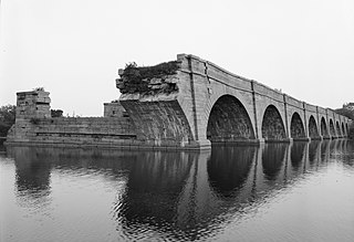
Schoharie Crossing State Historic Site, also known as Erie Canal National Historic Landmark, is a historic district that includes the ruins of the Erie Canal aqueduct over Schoharie Creek, and a 3.5-mile (5.6 km) long part of the Erie Canal, in the towns of Glen and Florida within Montgomery County, New York. It was the first part of the old canal to be designated a National Historic Landmark, prior to the designation of the entire New York State Barge Canal as an NHL in 2017.
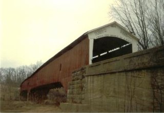
The West Union Covered Bridge formerly carried Tow Path Road over Sugar Creek north-northeast of Montezuma, Indiana. The two-span Burr Arch Truss covered bridge structure was built by Joseph J. Daniels in 1876. It is notable for being the longest standing covered bridge in Parke County, and one of the nation's best-preserved examples of the Burr truss.

The Union Covered Bridge State Historic Site is a Missouri State Historic Site in Monroe County, Missouri. The covered bridge is a Burr-arch truss structure built in 1871 over the Elk Fork of the Salt River. It was almost lost to neglect in the 1960s, but was added to the state park system in 1967, the same year it was damaged by a flood. Repairs were made the next year, using timbers salvaged from another covered bridge that had been destroyed by the same flood. In 1970, it was closed to vehicular traffic and was added to the National Register of Historic Places. Further repairs were made in 1988, and it survived the Great Flood of 1993, only to be damaged by another flood in 2008 and later re-repaired. It is about 120 feet (37 m) or 125 feet (38 m) long, 12 feet (3.7 m) high, and 17.5 feet (5.3 m) wide.

Chevelon Creek Bridge is a historic road bridge located about 12 miles (19 km) southeast of Winslow, in Navajo County, eastern Arizona, United States. It is a steel Warren Pony truss bridge over Chevelon Creek, built on the first permanent road connecting Holbrook, the seat of Navajo County, and Winslow. When built, the road was regionally important in northern Arizona as well as being a segment of an early national highway at the time automobile traffic was growing and national roads were first being formed. The bridge was listed on the National Register of Historic Places in 1983 for being a rare design in Arizona, part of an early transnational roadway, one of the first bridges built by Arizona after statehood in 1912, and being in nearly original condition.

There are eight properties listed on the National Register of Historic Places (NRHP) in Linn County, Kansas. Two of the sites are the location of historic events. The Marais des Cygnes Massacre Site is the location of the Marais des Cygnes massacre, an 1858 event during Bleeding Kansas in which pro-slavery advocates kidnapped 11 anti-slavery settlers, killing five of them. John Brown temporarily used the site as a fort, and the property was listed on the NRHP in 1971. The Battle of Mine Creek Site preserves the location of the Battle of Mine Creek, which was fought in 1864 as part of Price's Raid during the American Civil War. Confederate general Sterling Price's army was retreating after being defeated at the Battle of Westport and was attacked by pursuing Union troops. Price's Confederate lost heavily in men and supplies. The site was added to the NRHP in 1973.

The Colorado Department of Highways is the antecedent of today's Colorado Department of Transportation.
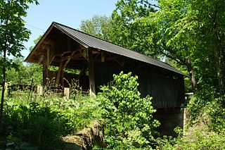
The Seguin Covered Bridge, also called the Upper Covered Bridge and the Sequin Covered Bridge, is a wooden covered bridge that crosses Lewis Creek in Charlotte, Vermont on Roscoe Road. It was built about 1850, and is a distinctive variant of a Burr arch design. It was listed on the National Register of Historic Places in 1974.

The Larkin Covered Bridge is a 60-foot-long (18 m), Burr truss wooden covered bridge that is located outside of Chester Springs, Chester County, Pennsylvania, near the village of Eagle. The bridge, which originally crossed over Marsh Creek, now spans a dry ditch and is a feature of the Upper Uwchlan Township trail system.

The Samuel Morey Memorial Bridge is a historic bridge carrying New Hampshire Route 25A across the Connecticut River between Orford, New Hampshire and Fairlee, Vermont. The steel through-arch bridge was built in 1937–38 to replace an older wooden bridge which had been damaged by flooding in 1936. It spans 432 feet (132 m), stands about 35 feet (11 m) above the river, and its arches rise 85 feet (26 m) above the roadway. It rests on poured concrete abutments that have a light Art Deco or Moderne styling. Wing walls recede from the abutments into the banks in three stepped sections. Below the bridge in the river is visible some riprap, stone remnants of the old bridge's abutments and central pier. The bridge is of a "tied arch" design, in which the two arches are joined together by ties to distribute the active load. This is in contrast to the Justice Harlan Fiske Stone Bridge joining Brattleboro, Vermont and Chesterfield, New Hampshire, which was built about the same time, and distributes the active load to its abutments. The bridge components were manufactured by the American Bridge Company; construction was by Hagen-Thibodeau Construction Company at a contracted cost of just over $209,000.
The War Eagle Creek Bridge is a historic bridge in northern Madison County, Arkansas. It carries County Road 1650 across War Eagle Creek northeast of Huntsville, and just north of creek crossing of United States Route 412. The bridge is a two-span open-spandrel concrete arch bridge, with a total length of 206 feet (63 m). Each arch spans 70 feet (21 m), and they are mounted on concrete abutments and a central pier. Built in 1925–26, it is the county's only known surviving example of this bridge type.

The Marble Bridge, formally known as the Fletcher D. Proctor Memorial Bridge, carries Main Street across Otter Creek in the center of Proctor, Vermont. Built in 1915, and widened in 1935-36, it is a well-preserved example of early concrete bridge construction, and is decoratively faced in local marble. The bridge was listed on the National Register of Historic Places in 1991.

Arch Street Bridge is Parker truss bridge over the Passaic River in Paterson, New Jersey. It was built in 1907 and rehabilitated in 1997. It was the third structure built at the location within a few years; the prior bridges were destroyed by floods in 1902 and 1903.

The West Sixth Street Bridge is a historic stone arch bridge in downtown Austin, Texas. Built in 1887, the bridge is one of the state's oldest masonry arch bridges. It is located at the site of the first bridge in Austin, carrying Sixth Street across Shoal Creek to link the western and central parts of the old city. The bridge was added to the National Register of Historic Places in 2014.
The Minnesela Bridge is a historic bridge located in Butte County, South Dakota. Formally known as South Dakota Department of Transportation Bridge No. 10-114-395, it passes over Redwater Creek about 1.5 miles (2.4 km) southeast of Belle Fourche. It was built in 1917 and was listed on the National Register of Historic Places in 1993 as part of the Historic Bridges in South Dakota Multiple Property Submission. It was one of the earliest concrete bridges constructed in the state. Concrete Engineering Company built multiple concrete bridges in the Rapid City area in the late 1910s, and due to the quality of their construction, many have survived. The bride was built at a cost of $2,588. Its common name is in reference to the nearby site of the ghost town of Minnesela, which sits just a few feet east of the bridge.

The West Fifth Street Bridge is a historic cantilever concrete girder bridge in downtown Austin, Texas. Built in 1931, the bridge carries Fifth Street across Shoal Creek to link central Austin with neighborhoods that were then the city's western suburbs. It is one of only a handful of curved cantilever girder bridges in Texas, built as part of the city's 1928 master plan for urban development and beautification. The bridge was added to the National Register of Historic Places in 2019.

