
Kennington is a district in south London, England. It is mainly within the London Borough of Lambeth, running along the boundary with the London Borough of Southwark, a boundary which can be discerned from the early medieval period between the Lambeth and St George's parishes of those boroughs respectively. It is located 1.4 miles (2.3 km) south of Charing Cross in Inner London and is identified as a local centre in the London Plan. It was a royal manor in the parish of St Mary, Lambeth in the county of Surrey and was the administrative centre of the parish from 1853. Proximity to central London was key to the development of the area as a residential suburb and it was incorporated into the metropolitan area of London in 1855.

Burgess Park is a public park situated in Camberwell the London Borough of Southwark, and is close to Walworth to the north, Bermondsey to the east and Peckham to the south. At 56 hectares, it is one of the largest parks in South London.

St Anne's Limehouse is a Hawksmoor Anglican Church in Limehouse, in the London Borough of Tower Hamlets. It was consecrated in 1730, one of the twelve churches built through the 1711 Act of Parliament.
The Cuming Museum in Walworth Road in Elephant and Castle, within the London Borough of Southwark, London, England, was a museum housing the collection of the Cuming family and later collections on Southwark's history. As of 2021, its collections have been rehoused in a new Southwark Heritage Centre.
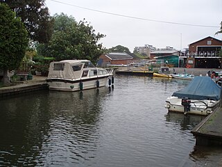
Trowlock Island is a residential island in the River Thames 450 metres (490 yd) upstream of Teddington Lock on the non-tidal Kingston reach less than 10 metres from the northern bank, in the London Borough of Richmond upon Thames, England.

The Prescott Channel was built in 1930–35 as part of a flood relief scheme for the River Lee Navigation in the East End of London, England, and was named after Sir William Prescott, the then chairman of the Lee Conservancy Board. Rubble from the demolished Euston Arch was used in 1962 to improve the channel, which forms part of the Bow Back Rivers.
Lorrimore Square is a 1.5-acre (0.6 ha) garden square in the far south-west of Southwark, London, England, centred 500 metres south-east of Kennington tube station. It is divided into four sections, a church with integrated drop-in centre; a small enclosed garden without paths; a public playground/gardens; and a basketball/netball pitch. One side of the square is classical architecture of four storeys, the other two sides — the fourth side marks the end of units on another road — are late 20th century rows of apartments of slightly lower height.

Christchurch was a civil parish in the metropolitan area of London, England. It was located south of the River Thames straddling either side of Blackfriars Road. It originated as the manor of Paris Garden in the parish of St Margaret, Southwark. The parish of St Margaret was replaced by St Saviour in 1541 and then in 1670 the area was split off as a parish in its own right when Christ Church was constructed. It was prone to flooding and was not heavily built upon until after 1809. In 1855 the parish was included in the metropolitan area of London where local government was reformed. The parish was united with St Saviour to form part of the St Saviour's District. When the district was abolished in 1900 the parish became part of the Metropolitan Borough of Southwark. It was abolished as a civil parish in 1930. The area now forms the northwestern part of the London Borough of Southwark.
The Spike Surplus Scheme was a community-run self-managed social centre in a squatted building in Peckham, South London. It was occupied in 1999 and provided a range of mostly free activities for local people until its eviction in 2009 by Southwark Council.

Long Lane is a main east–west road in Southwark, south London, England.

The Heygate Estate was a large housing estate in Walworth, Southwark, South London comprising 1,214 homes. The estate was demolished between 2011 and 2014 as part of the urban regeneration of the Elephant & Castle area. Home to more than 3,000 people, it was situated adjacent to Walworth Road and New Kent Road, and immediately east of the Elephant & Castle road intersection. The estate was used extensively as a filming location, due in part to its brutalist architecture.

Three Mills Residential Moorings is a community of twenty residential narrowboats moored on the Three Mills Wall River Weir near Three Mills in Mill Meads.

Southwark London Borough Council is the local authority for the London Borough of Southwark in Greater London, England. It is a London borough council, one of 32 in the United Kingdom capital of London.
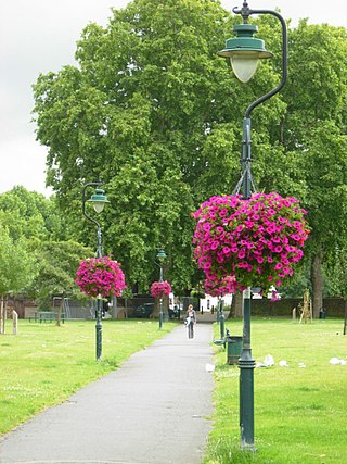
Geraldine Mary Harmsworth Park is a public park in Kennington, South London. Maintained by the London Borough of Southwark, it is bounded by Lambeth Road, Kennington Road, St George's Road and Brook Drive. It covers an area of 5.9 hectares. The grounds of the park surround its central feature, the Imperial War Museum London.

Dulwich Upper Wood is a 2.4 hectare local nature reserve and Site of Borough Importance for Nature Conservation, Grade 1, in Crystal Palace in the London Borough of Southwark. It is owned by Southwark Council and managed by the Trust for Urban Ecology.

Lavender Pond is a 2.5 acre local nature reserve in Rotherhithe in the London Borough of Southwark. It is owned by Southwark Council and managed by The Conservation Volunteers. The nature reserve has an area of woodland as well as the pond.

The Centre for Wildlife Gardening is a 0.22-hectare (0.54-acre) nature reserve in Peckham in the London Borough of Southwark. It is owned by Southwark Council and managed by the London Wildlife Trust. It is a Site of Borough Importance for Nature Conservation, Grade I.

Tabard Gardens is a small park in Southwark, London. It is located on Tabard Street and gives its name to the surrounding Tabard Gardens Estate. The park was created as part of a slum clearance programme by the London County Council and opened in 1929. It is owned and managed by Southwark Council.

Brimmington Park is a small 1.79 hectares park in Peckham, London. It is located on Old Kent Road, Clifton Crescent and Culmore Road, London SE15 2RQ. It is also adjacent to the former Old Kent Road and Hatcham railway station, which closed temporarily in 1917 but which has never been re-opened.
St Mary's Gardens is an 18th-century garden triangle in Central London. The "square" is in the London Borough of Lambeth and has an unusual triangular shape. Since 1968 in planning policy it is a Conservation Area. Three rows of houses front its communal green, granted Grade II listed status under the statutory protective and recognition scheme in 1981.
